International Appalachian Trail

Last updated • 3 min readFrom Wikipedia, The Free Encyclopedia
International Appalachian Trail
IAT SIA NA Map.jpg
Map of the International Appalachian Trail in Maine and Canada [1]
Length2,540 km (1,580 mi)
Location Maine, United States, and Canada
Trailheads Katahdin Woods and Waters National Monument, MaineCrow Head, Newfoundland and Labrador
UseHiking
Highest point Mount Katahdin
Lowest point Cap Gaspé

The International Appalachian Trail (IAT; French : Sentier international des Appalaches, SIA) was originally a hiking trail which ran from Katahdin Woods and Waters National Monument, in Maine, through New Brunswick, to the Gaspé Peninsula of Quebec, after which it followed a ferry route to Newfoundland, and then continued to the northern-easternmost point of the Appalachian Mountains at Belle Isle, Newfoundland and Labrador. [2] As of July 2020, there are widely geographically dispersed IAT-branded walking trails in Greenland, Iceland, Norway, Sweden, Denmark, Scotland, Northern Ireland, Ireland, Isle of Man, Wales, England, Spain, Portugal, and Morocco. [3]

Contents

History

The IAT was proposed in 1994 by Richard Anderson, a Maine fisheries biologist, with plans to traverse the portions of the Appalachian Mountains in Maine, New Brunswick, and Quebec that the Appalachian Trail did not cover. Following route selection, construction of the trail took place through the late 1990s.

The first person to thruhike the IAT, as it then existed, was John Brinda from Washington State, in 1997. He did this as part of a long-distance hike of what is known as the Eastern Continental Trail starting in Key West, Florida ending at Cap Gaspé in Quebec. He was the first person to thruhike the entire Eastern Continental Trail.

The Newfoundland and Labrador extension to the IAT was proposed in 2003 and is still under construction. When completed, it will add an additional 1,200 km of trail. The official opening of the first trail section of the IAT Newfoundland was September 23, 2006.

In 2009, IAT officials met with the British Geological Survey in Scotland to discuss whether to extend the IAT to the Appalachian terrains of Scotland, Ireland, Northern Ireland, and Wales, setting off a series of expansions through Europe and Northern Africa in which existing trails co-branded with the IAT.

Route

The IAT/SIA starts in Katahdin Woods & Waters National Monument in the U.S. State of Maine. Thence to Mars Hill, Maine, before following the U.S.-Canada border north to Fort Fairfield, Maine, where it crosses the border into Perth-Andover, New Brunswick. It continues up the Tobique River valley to Mount Carleton before crossing the Miramichi Highlands to the Restigouche River valley in Quebec and along the Chic-Choc Mountains of the Gaspé Peninsula, ending at the peninsula's easternmost point, Cap Gaspé in Forillon National Park.

End of the trail in Quebec at Cap Gaspe. International Appalachian Trail Cap Gaspe.jpg
End of the trail in Quebec at Cap Gaspé.

From Cap Gaspé, the IAT skips to a small section in Prince Edward Island, Nova Scotia, [4] and over the Gulf of St. Lawrence to Newfoundland, where the trail picks up again at Channel-Port aux Basques and follows the west coast of the island up the Great Northern Peninsula before terminating at the island's northernmost tip, Cape Bauld. From there the IAT skips over the Strait of Belle Isle to the northern terminus of the Appalachian Mountain chain at Belle Isle.

Extension to Europe and North Africa

Geological evidence shows that the Appalachian Mountains, certain mountains of Western Europe, and the Anti-Atlas range in North Africa are parts of the ancient Central Pangean Mountains, made when minor supercontinents collided to form the supercontinent Pangaea more than 250 million years ago. With the break-up of Pangaea, sections of the former range remained with the continents as they drifted to their present locations. Inspired by this evidence, the IAT has been extended into Western Europe and North Africa. [5]

In 2010 and 2011, chapters of the International Appalachian Trail were established in Greenland, Scotland (the West Highland Way became the first IAT trail in Europe), Norway, Sweden, Denmark, the Netherlands, England, Ulster-Ireland, Wales, the Faroe Islands, Iceland, Spain and Morocco. [6]

Highlights

Parks along the IAT include:

Canada

Europe

See also

Related Research Articles

<span class="mw-page-title-main">Gulf of St. Lawrence</span> Outlet of the North American Great Lakes via the St. Lawrence River into the Atlantic Ocean

The Gulf of St. Lawrence fringes the shores of the provinces of Quebec, New Brunswick, Nova Scotia, Prince Edward Island, Newfoundland and Labrador, in Canada, plus the islands Saint-Pierre and Miquelon, possessions of France, in North America.

<span class="mw-page-title-main">Strait of Belle Isle</span> Strait in Newfoundland and Labrador

The Strait of Belle Isle is a waterway in eastern Canada, that separates Labrador from the island of Newfoundland, in the province of Newfoundland and Labrador.

<span class="mw-page-title-main">Gaspé Peninsula</span> Peninsula in Quebec, Canada

The Gaspé Peninsula, also known as Gaspesia, is a peninsula along the south shore of the St. Lawrence River that extends from the Matapedia Valley in Quebec, Canada, into the Gulf of St. Lawrence. It is separated from New Brunswick on its southern side by Chaleur Bay and the Restigouche River. The name Gaspé comes from the Mi'kmaq word gespe'g, meaning "end", referring to the end of the land.

<span class="mw-page-title-main">Appalachian Mountains</span> Mountain range in eastern North America

The Appalachian Mountains, often called the Appalachians, are a mountain range in eastern to northeastern North America. The term "Appalachian" refers to several different regions associated with the mountain range, and its surrounding terrain. The general definition used is one followed by the United States Geological Survey and the Geological Survey of Canada to describe the respective countries' physiographic regions. The U.S. uses the term Appalachian Highlands and Canada uses the term Appalachian Uplands; the Appalachian Mountains are not synonymous with the Appalachian Plateau, which is one of the provinces of the Appalachian Highlands.

<span class="mw-page-title-main">Labrador Peninsula</span> Quebec Labrador peninsula in eastern Canada

The Labrador Peninsula or Quebec-Labrador Peninsula, is a large peninsula in eastern Canada. It is bounded by Hudson Bay to the west, the Hudson Strait to the north, the Labrador Sea to the east, Strait of Belle Isle and the Gulf of St. Lawrence to the southeast. The peninsula includes the region of Labrador, which is part of the province of Newfoundland and Labrador, and the regions of Saguenay–Lac-Saint-Jean, Côte-Nord, and Nord-du-Québec, which are in the province of Quebec. It has an area of 1,400,000 km2 (541,000 sq mi).

<span class="mw-page-title-main">Forillon National Park</span> National park in Quebec, Canada

Forillon National Park, one of 42 national parks and park reserves across Canada, is located at the outer tip of the Gaspé Peninsula of Quebec and covers 244 km2 (94 sq mi).

<span class="mw-page-title-main">Notre Dame Mountains</span> Portion of the Appalachian Mountains in Quebec and Vermont

The Notre Dame Mountains are a portion of the Appalachian Mountains, extending from the Gaspé Peninsula of Quebec to the Green Mountains of Vermont.

<span class="mw-page-title-main">Great Northern Peninsula</span> Peninsula of Newfoundland, Canada

The Great Northern Peninsula is the largest and longest peninsula of Newfoundland, Canada, approximately 270 km long and 90 km wide at its widest point and encompassing an area of 17,483 km2. It is defined as that part of Newfoundland from Bonne Bay northwards around Cape Norman and Cape Bauld and thence southwards to the head of White Bay, bounded by the Gulf of St. Lawrence on the west, the Strait of Belle Isle on the north and the Labrador Sea and White Bay on the east.

<span class="mw-page-title-main">Quebec Route 197</span> Highway in Quebec

Route 197 is a short 19 km two-lane highway which cuts through the Appalachian Mountains in the municipality of Gaspé, Quebec, Canada. Its only function is to act as a shortcut to Route 132 which goes around the Forillon peninsula which makes up Forillon National Park. It starts at the junction of Route 132 in Rivière-au-Renard and ends again at the junction of Route 132 in Saint-Majorique, part of Gaspé as well.

<span class="mw-page-title-main">Geography of Newfoundland and Labrador</span>

Newfoundland and Labrador is the easternmost province in Canada. The Strait of Belle Isle separates the province into two geographical regions, Labrador and the island of Newfoundland. The province also includes over seven thousand small islands.

<span class="mw-page-title-main">New England–Acadian forests</span> Temperate broadleaf and mixed forest ecoregion of Canada and the United States

The New England-Acadian forests are a temperate broadleaf and mixed forest ecoregion in North America that includes a variety of habitats on the hills, mountains and plateaus of New England and New York State in the Northeastern United States, and Quebec and the Maritime Provinces of Eastern Canada.

<span class="mw-page-title-main">Eastern Continental Trail</span> Long-distance hiking trail in the United States and Canada

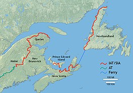
The Eastern Continental Trail (ECT) is a network of hiking trails in the United States and Canada, reaching from Key West, Florida to Belle Isle, Newfoundland and Labrador.

The history of lighthouses in Canada dates to 1734.

St. Barbe is an unincorporated settlement in Newfoundland and Labrador. It is located on the Great Northern Peninsula of the island of Newfoundland near Pigeon Cove. St. Barbe and Pigeon Cove together have a population of 135 as of 2016.

<span class="mw-page-title-main">Newfoundland (island)</span> Island portion of Newfoundland and Labrador, Canada

Newfoundland is a large island within the Canadian province of Newfoundland and Labrador. It is situated off the eastern coast of the North American mainland and the geographical region of Labrador.

<span class="mw-page-title-main">Eastern Canadian Boreal Forests</span> Taiga ecoregion of eastern Canada

The Eastern Canadian Boreal Forests is a boreal ecoregion in Eastern Canada, defined by the One Earth ecoregion categorization system.

<span class="mw-page-title-main">Bluestack Way</span> Walking trail in County Donegal, Ireland

The Bluestack Way is a long-distance trail through the Bluestack Mountains in County Donegal, Ireland. It is 65 kilometres long and begins in Donegal and ends in Ardara. It is typically completed in three days. It is designated as a National Waymarked Trail by the National Trails Office of the Irish Sports Council and is managed by the Bluestack Way Management Committee.

References

  1. "The Trail". The IAT/SIA Council.
  2. "Canadian Geographic: International Appalachian Trail Canada 2010".
  3. "IAT-SIA.org "The Trail" July 2020" . Retrieved 2020-07-22.
  4. Description of Nova Scotia trail section
  5. Adams, Glenn (June 10, 2010). "Appalachian Trail to leap abroad toward Morocco". KVAL-TV . Archived from the original on December 17, 2014.
  6. "History". Maine IAT. Archived from the original on 17 Dec 2014.
  7. "Causeway Coast Way". 26 January 2019.
  8. "Pembrokeshire Coast National Park - A Wonder Filled Coast".
  9. "The West Highland Way, Milngavie, Fort William, Walking in Scotland - Links". Archived from the original on 2007-01-19.