The Crack (trail)

Last updated
The Crack (trail)
Top of The Crack trail Killarney.png
View from the summit of The Crack
Length7.5 km (4.7 mi)
Location Killarney Provincial Park, Ontario
Trailheads The Crack (Parking Lot)
Use Hiking
Highest point355 m (1,165 ft)
DifficultyModerately challenging
SeasonYear-round
SightsPanoramic view of the surrounding mountains and lakes, quartzite cliff filled with boulders
Hazards Severe weather
Black Bear
Mosquitos
Biting flies
Steep grades
Diarrhea from water
Trail map
The Crack Trail map Alltrails OpenStreetMap.png
Elevation map showing The Crack

The Crack trail is a 7.5-kilometre out-and-back trail located in Killarney Provincial Park in Ontario, Canada. [1] It is known for the quartzite cliff which creates a formation resembling a crack in the mountain filled with boulders, and the panoramic views of the mountains and lakes at the peak.

Contents

Description

The trail starts off at relatively flat ground, connected with the La Cloche Silhouette Trail ( 46°02′39″N81°19′27″W / 46.0441°N 81.3243°W / 46.0441; -81.3243 (The Crack Trail, trailhead) ). As the La Cloche Silhouette Trail diverges after only 1.5 kilometres, hikers are given an opportunity to proceed with the hike or take the La Cloche Silhouette Trail as usual. Continuing along, after 0.3 more kilometres, hikers will be able to see their first glimpse of the mountains from the Kakakise Wood Bridge which goes across the Kakakise Lake. [2] Hikers will continue on the lakeshore which has many areas usable for swimming for the next 0.8 kilometres. [1]

At this point, they will begin the ascension of the mountain. At the start, they will be going through steep, heavily forested hills, and they will begin to notice patches of rocks. [3] After 0.6 kilometres of going up, the forest will have finished as the ground will have become quartzite by this point, so the hiker would have a view of surrounding mountains. [4] After 0.4 kilometres, they will encounter The Crack, a valley in the mountain filled with boulders created by boulders fallen from a slicing cliff, resembling a crack in the mountains, which the trail is named after. [5] [6] [7] [8] [9] [10] The hiker is required to climb the boulders through this valley to continue. [11]

After climbing through the quartzite boulder covered area for 0.2 kilometres, the hiker will reach the summit ( 46°03′41″N81°20′54″W / 46.0614°N 81.3482°W / 46.0614; -81.3482 (The Crack Trail, summit) ), where they will be greeted by a panoramic view of Killarney Lake, OSA Lake, the Georgian Bay, and the surrounding mountains. [12]

Etymology

The Crack is named after the a valley in the mountain filled with rocks created by a cliff, which resembles a crack in mountain due to the rough, slicing nature of the valley. [5] [6] [7] [8] [9] [10]

This quartzite cliff creates what appears to be a crack in the mountain filled with boulders The Crack rocks.jpg
This quartzite cliff creates what appears to be a crack in the mountain filled with boulders

Related Research Articles

<span class="mw-page-title-main">Killarney, Ontario</span> Municipality in Ontario, Canada

Killarney is a municipality located on the northern shore of Georgian Bay in the Sudbury District of Ontario, Canada. Killarney is commonly associated with Killarney Provincial Park, which is a large wilderness park located to the east of the townsite which occupies much of the municipality's expanded boundary. In addition to the community of Killarney itself, the communities of Hartley Bay and Bigwood, and the ghost towns of French River, Collins Inlet and Key Harbour, are also located within the municipal boundaries. The eastern end of the La Cloche Mountain Range is also located within the municipality of Killarney.

<span class="mw-page-title-main">Nickel Belt (federal electoral district)</span> Federal electoral district in Ontario, Canada

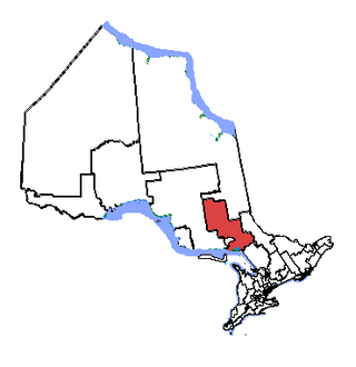
Nickel Belt is one of two federal electoral districts serving the city of Greater Sudbury, Ontario, Canada. It has been represented in the House of Commons of Canada since 1953.

<span class="mw-page-title-main">Sables-Spanish Rivers</span> Township in Ontario, Canada

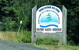
Sables-Spanish Rivers is a township in Ontario, Canada, on the north shore of Georgian Bay. It is located in the Sudbury District, approximately 70 kilometres (43 mi) west of Sudbury.

<span class="mw-page-title-main">Manitoulin District</span> District in Ontario, Canada

Manitoulin District is a district in Northeastern Ontario within the Canadian province of Ontario. It was created in 1888 from part of the Algoma District. The district seat is in Gore Bay.

<span class="mw-page-title-main">Mississagi River</span> River in Ontario, Canada

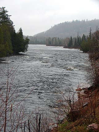
The Mississagi River is a river in Algoma and Sudbury Districts, Ontario, Canada, that originates in Sudbury District and flows 266 kilometres (165 mi) to Lake Huron at Blind River, Algoma District.

<span class="mw-page-title-main">Cypress Hills Interprovincial Park</span> Interprovincial park in Western Canada

Cypress Hills Interprovincial Park is a natural park in Canada straddling the Alberta / Saskatchewan boundary and jointly administered by the two provinces. Located south-east of Medicine Hat in the Cypress Hills, it became Canada's first interprovincial park in 1989.

<span class="mw-page-title-main">Killarney Provincial Park</span> Provincial park in Ontario, Canada

Killarney Provincial Park is a provincial park in central Ontario, Canada.

<span class="mw-page-title-main">Tonquin Valley</span> Valley in Alberta, Canada

The Tonquin Valley is located in Jasper National Park, Alberta, Canada, next to the border of the provinces of Alberta and British Columbia, an area which is also the continental divide, running along the peaks of the South Jasper Range which rise above Amethyst Lake. Tonquin Creek drains Moat Lake and flows west into Mount Robson Provincial Park in British Columbia, and empties into the Fraser River. The Astoria River drains south and east into the Athabasca River.

<span class="mw-page-title-main">Cartier, Ontario</span> DPL in Ontario, Canada

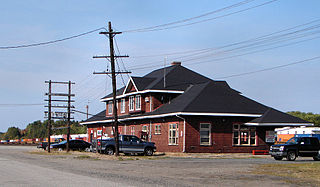
Cartier is a community in the Canadian province of Ontario, located in the Sudbury District approximately 20 kilometres (12 mi) north of the northwestern city limits of Greater Sudbury along Highway 144.

<span class="mw-page-title-main">La Cloche Silhouette Trail</span>

The La Cloche Silhouette Trail is a 78-kilometre (48 mi) backpacking loop across the white quartzite peaks of the La Cloche mountain range. The trail is situated in Killarney Provincial Park, Ontario, Canada. The trail is named for Group of Seven painter Franklin Carmichael's painting "La Cloche Silhouette." Wildlife can be seen throughout the trail - black bears, moose, wolverines, mountain lions, lynx, fishers, snakes, porcupines, beavers, river otters, among other animals, can be encountered at various points along the way.

<span class="mw-page-title-main">Urban neighbourhoods of Sudbury</span> Former city in Ontario, Canada

This is a list of neighbourhoods in the urban core of Greater Sudbury, Ontario. This list includes only those neighbourhoods that fall within the pre-2001 city limits of Sudbury — for communities within the former suburban municipalities, see the articles Capreol, Nickel Centre, Onaping Falls, Rayside-Balfour, Valley East and Walden.

<span class="mw-page-title-main">Wilkie Sugar Loaf trail</span> 3.2-km. (return) hiking trail ascending Wilkie Sugar Loaf Mountain

The Wilkie Sugarloaf Trail is a hiking trail in northern Cape Breton Island in the Canadian province of Nova Scotia. The trail leads to the 411.8 metres (1,351 ft) summit of Wilkie Sugar Loaf in the Cape Breton Highlands.

<span class="mw-page-title-main">La Cloche Mountains</span> Mountain range in Ontario, Canada

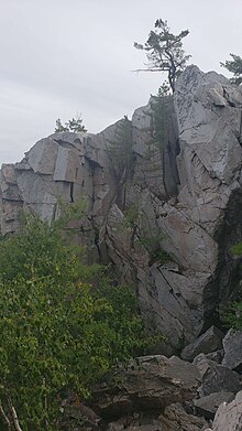
The La Cloche Mountains, also called the La Cloche Range, are a range of mountains in Northern Ontario, Canada, along the northern shore of Lake Huron near Manitoulin Island. The mountains are located in the Canadian Shield, and are composed primarily of white quartzite.

<span class="mw-page-title-main">Rainbow Country</span> Local Services Board in Ontario, Canada

Rainbow Country is a local services board in the Canadian province of Ontario. It encompasses and provides services to the communities of Whitefish Falls and Willisville in the Unorganized North Sudbury District and Birch Island and McGregor Bay in the Manitoulin District.

Provincial Trunk Highway 19 is a short east-west provincial highway in the west-central region of the Canadian province of Manitoba. It runs from PTH 5 near Norgate to PTH 10 near Wasagaming. Most of the road is situated within Riding Mountain National Park

William Lake Provincial Park is a provincial park located in the Rural Municipality of Morton, in southwest Manitoba on Turtle Mountain. Its sister park, the much larger Turtle Mountain Provincial Park, lies to the west.

Killarney Lakelands and Headwaters Provincial Park is a provincial park in central Ontario, Canada. Located primarily within the Sudbury District with a small portion located in the Walden area of Greater Sudbury, the park was created in 2006 as an expansion of the adjacent Killarney Provincial Park.

Point Grondine Park is a First Nations-owned nature park on the northern shore of Lake Huron in Sudbury District, Ontario, which occupies the unpopulated historic Point Grondine 3 Indian reserve. It is a ceded reserve of the Wiikwemkoong First Nation, having been reserved under the terms of the Robinson Huron Treaty in 1850.

<span class="mw-page-title-main">La Cloche Provincial Park</span> Provincial park in Ontario, Canada

La Cloche Provincial Park is a provincial park at the boundary of Algoma and Sudbury Districts in Ontario, Canada. The park consists of an unspoiled section of the La Cloche Mountains that stretch along the North Channel of Georgian Bay, as well as several islands in the channel.

Killarney Mountain Lodge is a resort located on Georgian Bay in Killarney, Ontario. Killarney Mountain Lodge contains the Canada House Conference Centre, the largest log-built conference centre in the world. The name "Canada House" comes from the local techniques, where people and materials were brought together in the completion of this structure. Construction started in 2017 and the building was finished in 2019.

References

  1. 1 2 "The Crack Trail". AllTrails.com. Retrieved 2024-01-21.
  2. "Kakakise Wood Bridge · Killarney, ON P0M 2A0, Canada". Kakakise Wood Bridge · Killarney, ON P0M 2A0, Canada. Retrieved 2024-01-21.
  3. "46°03'25.5"N 81°20'26.0"W · Sudbury District, ON P0M 2A0, Canada". 46°03'25.5"N 81°20'26.0"W · Sudbury District, ON P0M 2A0, Canada. Retrieved 2024-01-21.
  4. "46°03'34.6"N 81°20'42.4"W · Sudbury District, ON P0M 2A0, Canada". 46°03'34.6"N 81°20'42.4"W · Sudbury District, ON P0M 2A0, Canada. Retrieved 2024-01-21.
  5. 1 2 "Legendary Adventures with Backroads Bill: 'The Crack' at Killarney Provincial Park | Northern Ontario Travel". northernontario.travel. 2014-09-15. Retrieved 2024-01-21.
  6. 1 2 Roper, Stephen (2020-10-30). "The Crack Trail, Kilarney". Steve Roper. Retrieved 2024-01-21.
  7. 1 2 Bene, Tosh (2018-07-10). "Conquering The Crack – Hiking In Ontario's Killarney Provincial Park - Where in the World is Tosh" . Retrieved 2024-01-21.
  8. 1 2 Wagar, Kevin (2023-04-17). "Hiking the Crack in Killarney: A Complete Guide To One Of Ontario's Greatest Treks". Adventure Family Travel - Wandering Wagars. Retrieved 2024-01-21.
  9. 1 2 Davies, Lindsay (2020-01-15). "Hiking The Crack in Killarney: Your Winter Survival Guide » I've Been Bit! Travel Blog" . Retrieved 2024-01-21.
  10. 1 2 "Killarney Provincial Park: "The Crack" Hiking Guide". FLORAPHY. 2021-08-08. Retrieved 2024-01-21.
  11. "How to hike Killarney Provincial Park's "The Crack" Trail". Parks Blog. 2021-10-06. Retrieved 2024-01-21.
  12. "The Crack · Killarney, ON P0M 2A0, Canada". The Crack · Killarney, ON P0M 2A0, Canada. Retrieved 2024-01-21.