Skyline Trail (Jasper National Park)

Last updated
Skyline Trail
Skypan600.jpg
180-degree panorama, centre is looking east.
Length44 km (27 mi) [1]
Location Jasper National Park, Alberta, Canada
Trailheads Maligne Lake, Maligne Canyon
UseHiking
Elevation gain/loss1,410 m (4,626 ft) [1]
Highest pointNotch (2,511 m (8,238 ft)) [2]
Difficultyintermediate (3-day hike)

The Skyline Trail is a hiking trail in Jasper National Park, Alberta, Canada. [3] It is known for its views, with much of the hike being located above the tree line. It is also known for challenging weather conditions above the tree line, which can be a problem for hikers, who can lose sight of trails. [4]

Contents

The trail is recognized as one of the best backpacking trails in Jasper National Park, [5] and it is one of the busiest in the Rockies. [4] With 25 km of the total 44.1 km being at or above the tree line, it has views of the surrounding mountains and valley. It is normally hiked in two days from Maligne Lake to the bottom of Signal Mountain, but it may be completed at a more moderate pace, over three or four days. [5] It is recommended to hike the trail south to north from Maligne Lake, as the fire road descending to Signal Mountain on the northern end is an 800 m elevation loss. [6] There are three challenging passes, including the highest section of trail in Jasper National Park.

There are six campgrounds, located at 5 km, 8 km, 12 km, 19 km, 30 km, and 35 km (Evelyn Creek, Little Shovel, Snowbowl, Curator, Tekarra, and Signal, respectively). The campgrounds provide tent pads, picnic tables, bear poles with metal cables, connectors, and toilets. Skyline Trail is a no-fire zone. Camping is only permitted with reservations at the designated campgrounds.

Route

There are two main ways to enter the Skyline Trail. The more popular main trail; from the parking lot at Maligne Lake, the hike begins with a gentle walk through the forest past Lorraine and Mona Lakes, before crossing the Evelyn Creek bridge to the campground. The second option, adding 4 km and 500 m of elevation gain, is to climb the Bald Hills by using a well-established short cut for a view of Maligne Lake before heading down the fire road and joining the trail to the Evelyn Creek bridge.

The Evelyn Creek campground is a camping spot in the forest adjacent to the creek, but it is recommended that it be passed over for campgrounds at higher elevations. Following Evelyn Creek Campground the trail climbs to Little Shovel Pass. Because the campground after Little Shovel, Snowbowl, is heavily used, if possible Little Shovel Campground is an option for an overnight stay, especially as it is situated part way up Little Shovel Pass so it offers a respite from the steady climb.[ citation needed ] From Little Shovel Campground, the trail breaks out of the trees into the upper subalpine, continuing its climb to Little Shovel Pass at 10 km. Entering the Snowbowl, the Skyline Trail can be seen meandering through open meadows until it enters the trees wherein the Snowbowl Campground is sheltered.

Snowbowl is popular in both winter and summer,[ citation needed ] and it contains a small cabin called Shangrila, built by guide, Donald "Curly" Phillips, in 1936 for skiing enthusiasts. The cabin, administered by the Maligne Lake Ski Club, is not available to summer hikers.

From Snowbowl Campground, the ascent rises through flower-filled meadows to Little Shovel Pass at 17 km.

Crossing into the Curator Basin, the trail swings right, past the junction with the Watchtower Trail. A 4 km descent into this valley leads to the Watchtower Campground, an option as Curator Campground is heavily used and often fully booked.

Returning to the trail section in the Curator Basin, the Skyline Trail continues to the Wabasso Creek Trail junction at 19 km. Less than 1 km further along this trail is Curator Campground. A little further still is Shovel Pass Lodge, which does allow use by hikers; more frequently, however, horse trips use this lodge as a waypoint. Both the Watchtower and Wabasso trails are good foul weather escape routes off the Skyline, which as mentioned can be necessary as the weather along the Skyline Trail can be treacherous.[ original research? ] Beyond the Wabasso junction the Skyline Trail passes Curator Lake then makes a sudden, steep ascent to the Notch at 22 km, the highest point on the Skyline at 2511 m.

The next 4 km of the trail are along the crest of the Maligne Range, which is exposed to both mountain views and to mountain weather. The descent to Tekarra Campground follows a trail through rocky valley with Mount Tekarra on the left and Excelsior on the right. Centre Mountain dominates the head of the valley, lending its name to the creek and lakes below. Following Lower Centre Lake, the trail enters Tekarra Campground at 30 km. From Tekarra Campground, the trail crosses Centre Creek and borders the shoulders of Tekarra and Signal Mountains to the junction with the Signal Mountain Fire Road. The fire road climbs uphill for 1 km to the old Signal Mountain fire lookout site. Descending to the right, the fire road passes the junction into Signal Campground, then quickly descends further into the forest for the final leg of the trip. 800m of vertical are surrendered over the final 9 km.

Wildlife

The Skyline Trail is the home range of species that inhabit the mountain wilderness or near this area of the park. These include the timber wolf, black bear, coyote, grizzly bear, moose, white-tailed deer, bighorn sheep, marten, pika, mountain goat, lynx, marmot, mule deer, porcupine, beaver, elk, wolverine, and cougar. Raptors that inhabit in the trail's forest are great grey owls, golden eagles, great horned owls, and bald eagles.

The trail is recognized as critical woodland caribou habitat. The Boreal woodland Caribou is a threatened Species-at-Risk in Canada. In an attempt to reduce stressors, Parks Canada has banned dogs from all Caribou habitat in Jasper National Park.

History

In 1911 Jack Otto guided Mary Schäffer to Little Shovel Pass on the way to her survey of Maligne Lake. Their party found the way blocked by snow and dug their way through the pass using shovels fashioned from trees. The shovels were left behind and Mary named the pass "Shovel Pass". The shovels are now displayed at the museum in Jasper.

Related Research Articles

<span class="mw-page-title-main">Jasper National Park</span> National park in Alberta, Canada

Jasper National Park, in Alberta, Canada, is the largest national park within Alberta's Rocky Mountains, spanning 11,000 km2 (4,200 sq mi). It was established as Jasper Forest Park in 1907, renamed as a national park in 1930, and declared a UNESCO world heritage site in 1984. Its location is north of Banff National Park and west of Edmonton. The park contains the glaciers of the Columbia Icefield, springs, lakes, waterfalls and mountains.

<span class="mw-page-title-main">Kootenay National Park</span> National park in British Columbia, Canada

Kootenay National Park is a national park of Canada in southeastern British Columbia. The park consists of 1,406 km2 (543 sq mi) of the Canadian Rockies, including parts of the Kootenay and Park mountain ranges, the Kootenay River and the entirety of the Vermilion River. While the Vermilion River is completely contained within the park, the Kootenay River has its headwaters just outside the park boundary, flowing through the park into the Rocky Mountain Trench and eventually joining the Columbia River. The park ranges in elevation from 918 m (3,012 ft) at the southwestern park entrance to 3,424 m (11,234 ft) at Deltaform Mountain.

<span class="mw-page-title-main">Willmore Wilderness Park</span> Provincial park of Alberta, Canada

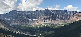
Willmore Wilderness Park, in Alberta, Canada, is a 4,600-square-kilometre (1,800 sq mi) wilderness area adjacent to Jasper National Park. It is lesser known and less visited than Jasper National Park. There are no public roads, bridges or buildings. There are, however, several ranger cabins in the park that are available as a courtesy to visitors.

<span class="mw-page-title-main">Kluane National Park and Reserve</span> National park and park reserve in Northwest Territories, Canada

Kluane National Park and Reserve are two protected areas in the southwest corner of the territory of Yukon. The National Park Reserve was set aside in 1972 to become a national park, pending settlement of First Nations land claims. It covered an area of 22,013 square kilometres. When agreement was reached with the Champagne and Aishihik First Nations over an eastern portion of the Reserve, that part—about 5,900 square kilometres —became a national park in 1993, and is a unit of the national park system administered co-operatively with Parks Canada. The larger western section remains a Reserve, awaiting a final land claim settlement with the Kluane First Nation. The park borders British Columbia to the south, while the Reserve borders both British Columbia to the south, and the United States (Alaska) to the south and west.

<span class="mw-page-title-main">Chilkoot Trail</span> Long-distance hiking trail in Canada and the United States

The Chilkoot Trail is a 33-mile (53 km) trail through the Coast Mountains that leads from Dyea, Alaska, in the United States, to Bennett, British Columbia, in Canada. It was a major access route from the coast to Yukon goldfields in the late 1890s. The trail became obsolete in 1899 when a railway was built from Dyea's neighbor port Skagway along the parallel White Pass trail.

<span class="mw-page-title-main">Maligne Lake</span> Lake in Alberta, Canada

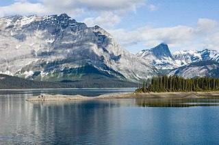
Maligne Lake is a lake in Jasper National Park, Alberta, Canada. The lake is famed for the colour of its azure water, the surrounding peaks, the three glaciers visible from the lake, and Spirit Island, a frequently and very famously photographed islet. The lake is located 44 km (27 mi) south of Jasper town, and is accessible by motor vehicle, including shuttle buses from Jasper. Boat tours run to Spirit Island in the spring to autumn season. The 44 km Skyline Trail, Jasper's most popular, highest and above treeline, multi-day hike, begins at Maligne Lake and finishes near the town of Jasper. Other popular day hikes include the Opal Hills and Bald Hills loops. Winter activities include cross-country skiing and snowboarding.

<span class="mw-page-title-main">Peter Lougheed Provincial Park</span> Provincial park in Alberta, Canada

Peter Lougheed Provincial Park is in Kananaskis Country about 90 kilometres (56 mi) west of Calgary, along the Kananaskis Trail in Alberta, Canada.

<span class="mw-page-title-main">Hamber Provincial Park</span> Provincial park in British Columbia, Canada

Hamber Provincial Park is a provincial park in British Columbia, Canada, located 130 kilometres (80.7 mi) north of Golden. Straddling the Great Divide on the provincial boundary with Alberta, the park is surrounded on three sides by Jasper National Park and protects the headwaters of the Wood River at Fortress Lake.

The Crystal Lake Recreation Area is located in the San Gabriel Mountains of Southern California, administered by the San Gabriel Mountains National Monument of the United States Forest Service. The Recreation Area consists of a small lake, an open-air amphitheater, a large public campground containing approximately 120 camp sites grouped into "loops," and a group campground called Deer Flats which consists of approximately 25 camp sites. The Recreation Area contains a United States Forest Service visitor center and a cafe which is open to the public from dawn to dusk except for Tuesdays when the cafe is closed. Within the Recreation Area are 16 hiking and nature trails which are well-maintained by volunteers who work under the direction of the Forest Service. The Recreation Area is located approximately 26 miles (42 km) north on Hwy. 39 heading out of Azusa, California at the headwaters of the north fork of the San Gabriel River at an elevation approximately 5,539 feet above sea level. Crystal Lake is the only naturally occurring lake in the San Gabriel Mountains.

<span class="mw-page-title-main">Lower Mount Cammerer Trail</span> Hiking trail in Tennessee, United States

The Lower Mount Cammerer Trail is an American hiking trail, in the Great Smoky Mountains National Park of Cocke County, Tennessee. The trail ascends Mount Cammerer, leading to a small, untraditional firetower at the summit, from which panoramic views of Cocke County, the main range of the Great Smoky Mountains, and the dominating presence of Mount Guyot are all prominent.

The Stanley Mitchell hut is an alpine hut located at an altitude of 2,060 metres (6,759 ft) in the Little Yoho Valley in Yoho National Park, British Columbia, Canada. It sits in a small meadow not far from the base of a mountain called The President. It serves as a base for hiking, scrambling, ski-touring and climbing the nearby mountains. The hut is maintained by the Alpine Club of Canada.

<span class="mw-page-title-main">Bald Eagle State Park</span> State park in Pennsylvania, United States

Bald Eagle State Park is a 5,900-acre (2,388 ha) Pennsylvania state park in Howard, Liberty, and Marion townships in Centre County, Pennsylvania in the United States. The park includes the Foster Joseph Sayers Reservoir, formed by damming Bald Eagle Creek and other smaller streams and covering 1,730 acres (700 ha). Bald Eagle State Park is at the meeting point of two distinct geologic features. The Allegheny Plateau is to the north and the Ridge and Valley area of Pennsylvania is to the south. The park is in the Bald Eagle Valley off Pennsylvania Route 150 in Howard, between Milesburg and Lock Haven.

The White Bear Forest is an old growth forest, located in Temagami, Ontario, Canada. The forest is named after Chief White Bear, who was the last chief of the Teme-Augama Anishnabai before Europeans appeared in the region. In some parts of the White Bear Forest trees commonly reach 200 to 300 years in age, while the oldest tree accurately aged in White Bear Forest was a red pine that was 400 years old in 1999. The White Bear Forest contains one of Canada's oldest portages, dating back some 3,000 years. Today, more than 17 km (11 mi) of trails access the White Bear Forest. A trail guide is available online at http://ancientforest.org/whitebear.html.

<span class="mw-page-title-main">Narrow Hills Provincial Park</span> Provincial park in Saskatchewan, Canada

Narrow Hills Provincial Park is a northern boreal forest provincial recreational park in the Canadian province of Saskatchewan. It is located in a hilly plateau called the Cub Hills and contains several recreational facilities and over 25 accessible lakes within its boundaries. The geographical features of the park, including the lakes, valleys, and lowlands were formed over 10,000 years ago during the last ice age. The town of Smeaton is the closest community and it is located 70 kilometres (43 mi) to the south.

Poke-O-Moonshine Mountain, spelled Pokamoonshine on U.S. Geological Survey maps, and sometimes known as just Poke-O, is a minor peak of the Adirondack Mountains. The name is believed to be a corruption of the Algonquin words pohqui, meaning 'broken', and moosie, meaning 'smooth'. It is located in the town of Chesterfield, New York, United States, on New York state Forest Preserve land, part of the Taylor Pond Wild Forest complex within the Adirondack Park. Due to its location next to the pass through which most travelers from the north enter the range, it has been called the "gateway to the Adirondacks".

<span class="mw-page-title-main">Curator Mountain</span> Mountain in the country of Canada

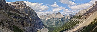
Curator Mountain is a 2,624-metre (8,609-foot) mountain summit located in the Maligne Range of Jasper National Park, in the Canadian Rockies of Alberta, Canada. Curator Mountain was so named on account of its central location, as if it were the "custodian" of Shovel Pass. The mountain was named in 1916 by Morrison P. Bridgland (1878-1948), a Dominion Land Surveyor who named many peaks in Jasper Park and the Canadian Rockies. The mountain's name was officially adopted in 1947 when approved by the Geographical Names Board of Canada. Its nearest higher peak is Trowel Peak, 7.7 km (4.8 mi) to the southeast. Curator Mountain is composed of sedimentary rock laid down during the Cambrian period and pushed east and over the top of younger rock during the Laramide orogeny.

<span class="mw-page-title-main">Mount Tekarra</span> Mountain in the country of Canada

Mount Tekarra is a 2,694-metre (8,839-foot) mountain summit located in the Athabasca River valley of Jasper National Park, in the Canadian Rockies of Alberta, Canada. It is situated at the northwest end of the Maligne Range and is visible from Jasper and the Icefields Parkway. The nearest higher neighbor is The Watchtower, 7.0 km (4.3 mi) to the east.

<span class="mw-page-title-main">The Watchtower (Alberta)</span> Mountain in the country of Canada

The Watchtower is a 2,791-metre (9,157 ft) mountain summit located in the Maligne River valley of Jasper National Park, in the Canadian Rockies of Alberta, Canada. It is situated in the Maligne Range and is visible from the Maligne Lake Road where it towers over Medicine Lake. Its nearest higher peak is Sirdar Mountain, 11.64 km (7.23 mi) to the north.

<span class="mw-page-title-main">Evelyn Peak</span> Mountain peak in Jasper NP, Alberta, Canada

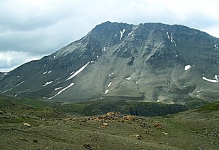
Evelyn Peak is a 2,855 m (9,367 ft) mountain summit in the Athabasca River valley of Jasper National Park, in the Canadian Rockies of Alberta, Canada. THe nearest higher peak is Mount Kerkeslin, 5.0 km (3.1 mi) to the southwest, and Mount Hardisty is 6.0 km (3.7 mi) to the northwest. All three are part of the Maligne Range. Evelyn Peak is composed of sedimentary rock laid down during the Cambrian period and pushed east and over the top of younger rock during the Laramide orogeny. The mountain is at the headwaters of Evelyn Creek, and three kilometres south of Evelyn Pass. The creek and pass were named in 1921 for Evelyn Cavendish, Duchess of Devonshire (1870–1960), who visited nearby Maligne Lake in 1920. The mountain's name however, has not yet been officially adopted by the Geographical Names Board of Canada.

References

  1. 1 2 "Jasper National Park Backcountry Guide" (PDF). Parks Canada. 2015. p. 2. Retrieved 10 November 2015.
  2. Hammel, Katie (24 October 2014). "Hiking to the top of Jasper National Park". BBC.com. Retrieved 10 November 2015.
  3. Parks Canada Agency, Government of Canada (May 24, 2018). "index - Jasper National Park". www.pc.gc.ca.
  4. 1 2 HikeJasper.com. "Hike Jasper – The Skyline Trail". www.hikejasper.com. Retrieved 2018-08-23.
  5. 1 2 "Backpacking the Skyline Trail in Jasper National Park". In A Faraway Land. 2017-09-10. Retrieved 2018-08-29.
  6. Canada, Parks Canada Agency, Government of. "Backcountry Guide". www.pc.gc.ca. Retrieved 2018-08-29.{{cite web}}: CS1 maint: multiple names: authors list (link)