The Bruce Trail is a hiking trail in southern Ontario, Canada, from the Niagara River to the tip of Tobermory, Ontario. The main trail is more than 890 km (550 mi) long and there are over 400 km (250 mi) of associated side trails. The trail mostly follows the edge of the Niagara Escarpment, one of the nineteen UNESCO World Biosphere Reserves in Canada. The land the trail traverses is owned by the Government of Ontario, local municipalities, local conservation authorities, private landowners, and the Bruce Trail Conservancy (BTC). The Bruce Trail is the oldest and longest marked hiking trail in Canada. Its name is linked to the Bruce Peninsula and Bruce County, through which the trail runs. The trail is named after the county, which was named after James Bruce, 8th Earl of Elgin who was Governor General of the Province of Canada from 1847 to 1854.

The Don River is a watercourse in southern Ontario that empties into Lake Ontario, at Toronto Harbour. Its mouth was just east of the street grid of the town of York, Upper Canada, the municipality that evolved into Toronto, Ontario. The Don is one of the major watercourses draining Toronto that have headwaters in the Oak Ridges Moraine.

The Humber River is a river in Southern Ontario, Canada. It is in the Great Lakes Basin, is a tributary of Lake Ontario and is one of two major rivers on either side of the city of Toronto, the other being the Don River to the east. It was designated a Canadian Heritage River on September 24, 1999.

Whitchurch-Stouffville is a town in the Greater Toronto Area of Ontario, Canada, approximately 50 km (31 mi) north of downtown Toronto, and 55 km (34 mi) north-east of Toronto Pearson International Airport. It is 206.22 km2 (79.62 sq mi) in area, and located in the mid-eastern area of the Regional Municipality of York on the ecologically-sensitive Oak Ridges Moraine. Its motto since 1993 is "country close to the city".

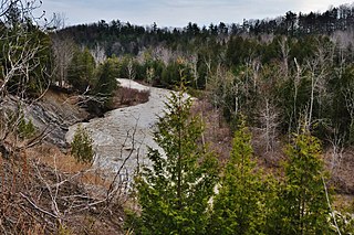
The Oak Ridges Moraine is an ecologically important geological landform in the Mixedwood Plains of south-central Ontario, Canada. The moraine covers a geographic area of 1,900 square kilometres (730 sq mi) between Caledon and Rice Lake, near Peterborough. One of the most significant landforms in southern Ontario, the moraine gets its name from the rolling hills and river valleys extending 160 km (99 mi) east from the Niagara Escarpment to Rice Lake, formed 12,000 years ago by advancing and retreating glaciers during the last glaciation period. Below the approximately 200 meter thick glacial derived sediments of the moraine lies thick bedrock successions of Precambrian rocks and up to 200 meters of Ordovician aged rock, capped by a regional unconformity of erosion and non-deposition to the Quaternary period. Rivers and lakes scatter the landscape and are important for creating habitat for the rich diversity of species of animals, trees and shrubbery. These are also the supply of fresh water to aquifers in the moraine through complex subterranean connections. Construction development nearby, and with expansion of communities around the moraine in need of potable water, it is a contested site in Ontario, since it stands in the path of major urban development. This region has been subject to multiple decades of scientific research to study the origins of formation, and how early communities used the land. A larger focus currently is how to source potable water without removing the aquifer entirely.

The Greenbelt is a 203.5-square-kilometre (78.6 sq mi) protected green belt traversing Ottawa, Ontario, Canada. It includes green space, forests, farms, and wetlands from Shirleys Bay in the west and to Green's Creek in the east. It is the largest publicly owned green belt in the world and the most ecologically diverse area in Eastern Ontario. The National Capital Commission (NCC) owns and manages 149.5 square kilometres (57.7 sq mi), and the rest is held by other federal government departments and private interests. Real estate development within the Greenbelt is strictly controlled.

Steve Gilchrist is a former politician in Ontario, Canada. He was a Progressive Conservative member of the Legislative Assembly of Ontario from 1995 to 2003, and served as a cabinet minister in the government of Mike Harris.

Bolton is an unincorporated village that is the most populous community in the town of Caledon, Ontario. It is located beside the Humber River in the Region of Peel, approximately 50 kilometres northwest of Toronto. In regional documents, it is referred to as a 'Rural Service Centre'. It has 26,795 residents in 9,158 total dwellings. The downtown area that historically defined the village is in a valley, through which flows the Humber River. The village extends on either side of the valley to the north and south.

King City is an unincorporated Canadian community in the township of King, Ontario, located north of Toronto. It is the largest community in King township, with 2,730 dwellings and a population of 8,396 as of the 2021 Canadian census.

Oak Ridges is an unincorporated community of Richmond Hill, Ontario, Canada, and has been part of the city since 1971. It forms the northern portion of the municipality's boundary, where it borders Aurora. Located about 20 km north of the northern border of Toronto and about 35 km from Downtown Toronto, it has a population of 18,520 (2016). The community developed around Lake Wilcox, the largest lake in the area, and has continued to expand slowly since its annexation by the Town of Richmond Hill. In the 1990s, Oak Ridges experienced moderate growth, which spurred environmental action by numerous organizations. Population has grown significantly as a result of development initiatives along Bayview Avenue. The Oak Ridges Community Center was built and completed in June 2012 to accommodate community demand.
Palgrave is a Compact Rural Community and unincorporated place in the Town of Caledon, Regional Municipality of Peel in the Greater Toronto Area of Ontario, Canada. It is about 10 kilometres (6.2 mi) north of Bolton and about 50 kilometres (31 mi) northwest of Toronto. Palgrave is located east of Orangeville, south of Alliston, west of Newmarket and north of Brampton.
Strange is an unincorporated community west of King City in King Township, Ontario, Canada. It is directly north of Laskay to the west of Highway 400, and is a sparsely populated agricultural area.

Moraine State Park is a Pennsylvania state park on 16,725 acres (6,768 ha) in Brady, Clay, Franklin, Muddy Creek, and Worth townships in Butler County, Pennsylvania.

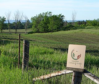
The Greenbelt is a protected area of green space, farmland, forests, wetlands, and watersheds, located in Southern Ontario, Canada. It surrounds a significant portion of the Golden Horseshoe.

The Capital Area Greenbelt is a looping trail located in the area of Harrisburg, Pennsylvania. This 20-mile loop around Pennsylvania's capital city provides visitors and tourists with opportunities to hike, ride bicycles, skate, jog, fish, walk their dogs, spot rare birds, learn about history, enjoy native flora and fauna, and appreciate nature. While parts of the trail are shared with roads, most of the loop is a dedicated path. The Trail, as it is commonly referred to by locals, passes along the Susquehanna River through Reservoir Park, Riverfront Park, Five Senses Garden, and Wildwood Park and Nature Center. In addition to parks, the Capital Area Greenbelt passes alongside attractions including the grave site of John Harris Sr., the Governor's Mansion, Fort Hunter, Harrisburg State Hospital, and the National Civil War Museum.

The Toronto ravine system is a distinctive feature of the city's geography, consisting of a network of deep ravines, which forms a large urban forest that runs through most of Toronto. The ravine system is the largest in any city in the world, with the Ravine and Natural Feature Protection Bylaw protecting approximately 110 square kilometres (42 sq mi) of public and privately-owned land. The ravine system has been presented as a central characteristic of the city, with the size of the ravine system leading Toronto to be described as "a city within a park".

Cold Creek Conservation Area, usually Cold Creek, is an ecologically diverse protected Area of Natural and Scientific Interest in south-central Ontario, Canada. The 190-hectare (470-acre) conservation area was opened on 20 June 1962 by Wilf Spooner and the Toronto and Region Conservation Authority. It is located on the western end of King Township, overlapping the Oak Ridges Moraine. The Government of Ontario Ministry of Natural Resources classifies the area as a provincially significant Area of Natural and Scientific Interest for its "provincially or regionally significant representative ecological features". The area was also a site classified for the International Biological Program. The Life Science area, known as Cold Creek Swamp, is composed of a swamp and forest.
The Oak Ridges Moraine Foundation (ORMF) is a non-profit organization based in Newmarket, Ontario, Canada. It was founded in 2002 as a governing body dedicated to the enhancement and preservation of the Oak Ridges Moraine as a healthy and vibrant ecosystem.
Albion Hills Conservation Area (AHCA) is located in the Town of Caledon within the Regional Municipality of Peel. AHCA is located eight kilometers north of Bolton, off of Highway 50 at 16500 Highway 50, Palgrave, Ontario. It is owned and managed by the Toronto and Region Conservation Authority (TRCA). AHCA sees about 120,000 visitors each year, who visit the conservation area for mountain biking, camping, swimming, special events, cross-country skiing and more.

The James River Face Wilderness is an 8,907-acre area located near Natural Bridge, Virginia that is protected by the Eastern Wilderness Act of Congress to maintain its present, natural condition. As part of the National Wilderness Preservation System, it helps to preserve a variety of natural life forms and contributes to a diversity of plant and animal gene pools. Over half of the ecosystems in the United States exist within designated wilderness.


