Related Research Articles

Vancouver Island is an island in the northeastern Pacific Ocean and part of the Canadian province of British Columbia. The island is 456 km (283 mi) in length, 100 km (62 mi) in width at its widest point, and 32,100 km2 (12,400 sq mi) in total area, while 31,285 km2 (12,079 sq mi) are of land. The island is the largest by area and the most populous along the west coasts of the Americas.
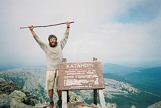
The Appalachian Trail, also called the A.T., is a hiking trail in the Eastern United States, extending almost 2,200 miles (3,540 km) between Springer Mountain in Georgia and Mount Katahdin in Maine, and passing through 14 states. The Appalachian Trail Conservancy claims the Appalachian Trail to be the longest hiking-only trail in the world. More than three million people hike segments of the trail each year.
The Pacific Crest Trail (PCT), officially designated as the Pacific Crest National Scenic Trail, is a long-distance hiking and equestrian trail closely aligned with the highest portion of the Cascade and Sierra Nevada mountain ranges, which lie 100 to 150 miles east of the U.S. Pacific coast. The trail's southern terminus is next to the Mexico–United States border, just south of Campo, California, and its northern terminus is on the Canada–US border, upon which it continues unofficially to the Windy Joe Trail within Manning Park in British Columbia; it passes through the states of California, Oregon, and Washington.

The Continental Divide National Scenic Trail is a United States National Scenic Trail with a length measured by the Continental Divide Trail Coalition of 3,028 miles (4,873 km) between the U.S. border with Chihuahua, Mexico and the border with Alberta, Canada. Frequent route changes and a large number of alternate routes result in an actual hiking distance of 2,700 miles (4,300 km) to 3,150 miles (5,070 km). The CDT follows the Continental Divide of the Americas along the Rocky Mountains and traverses five U.S. states — Montana, Idaho, Wyoming, Colorado, and New Mexico. In Montana near the Canadian border the trail crosses Triple Divide Pass.

The John Muir Trail (JMT) is a long-distance trail in the Sierra Nevada mountain range of California, passing through Yosemite, Kings Canyon and Sequoia National Parks. It is named after John Muir, a naturalist.

The Trans Canada Trail, officially named The Great Trail between September 2016 and June 2021, is a cross-Canada system of greenways, waterways, and roadways that stretches from the Atlantic to the Pacific to the Arctic oceans. The trail extends over 24,000 km (15,000 mi); it is now the longest recreational, multi-use trail network in the world. The idea for the trail began in 1992, shortly after the Canada 125 celebrations. Since then it has been supported by donations from individuals, corporations, foundations, and all levels of government.

Port Alberni is a city located on Vancouver Island in the province of British Columbia, Canada. The city lies within the Alberni Valley at the head of the Alberni Inlet, Vancouver Island's longest inlet. It is the location of the head offices of the Alberni-Clayoquot Regional District. Port Alberni currently has a total population of 18,259.

The Island Rail Corridor, previously the Esquimalt & Nanaimo Railway, is a dormant railway operation on Vancouver Island and is the only remaining railway there after the closure of the Englewood Railway in November 2017. The Island Corridor Foundation owns the former Esquimalt & Nanaimo Railway corridor. The railway line is 225 kilometres (140 mi) in length from Victoria to Courtenay, known as the Victoria Subdivision, with a branch line from Parksville to Port Alberni known as the Port Alberni Subdivision at 64 kilometres (40 mi) in length, for a total 289 kilometres (180 mi) of mainline track. In 2006, the Island Corridor Foundation acquired the railway's ownership from the Canadian Pacific Railway.

Duncan is a city on southern Vancouver Island in British Columbia, Canada. It is the smallest city by area in Canada. It was incorporated in 1912.
The Colorado Trail is a long-distance trail running for 486 miles (782 km) from the mouth of Waterton Canyon southwest of Denver to Durango in Colorado, United States. Its highest point is 13,271 feet (4,045 m) above sea level, and most of the trail is above 10,000 feet (3,000 m). Despite its high elevation, the trail often dips below the alpine timberline to provide refuge from the exposed, storm-prone regions above.

Ucluelet is a district municipality on the Ucluelet Peninsula, on the west coast of Vancouver Island in British Columbia, Canada. Ucluelet comes from Yuułuʔił which means "people of the safe harbour" in the indigenous Nuu-chah-nulth language and is the homeland of the Yuułuʔiłʔatḥ. As of 2021, its population was 2,066, a 20.3% increase from 1,717 in 2016.

North Cowichan is a district municipality established in 1873 on Vancouver Island, in British Columbia, Canada. The municipality is part of the Cowichan Valley Regional District. North Cowichan is noted for a landscape including forests, beaches, rivers, and lakes. The municipality encompasses the communities of Chemainus; Westholme; Crofton; Maple Bay; and "the South End". The latter is an informal name for a built-up area which is essentially a suburb of the City of Duncan, a separate municipality.
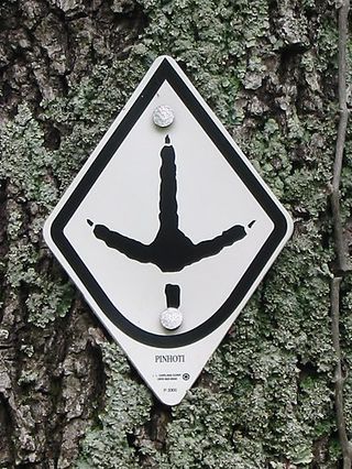
The Pinhoti Trail is a Southern Appalachian Mountains long-distance trail, 335 miles (540 km) in length, located in the United States within the states of Alabama and Georgia. The trail's southern terminus is on Flagg Mountain, near Weogufka, Alabama, the southernmost peak in the state that rises over 1,000 feet (300 m). The trail's northern terminus is where it joins the Benton MacKaye Trail. The trail's highest point is Buddy Cove Gap, with an elevation of 3164 feet near the Cohutta Wilderness. Its lowest point above sea level is close to Weogufka Creek near Weogufka State Forest at 545 feet.

The Cowichan Valley Regional District is a regional district in the Canadian province of British Columbia is on the southern part of Vancouver Island, bordered by the Nanaimo and Alberni-Clayoquot Regional Districts to the north and northwest, and by the Capital Regional District to the south and east. As of the 2021 Census, the Regional District had a population of 89,013. The regional district offices are in Duncan.
Thru-hiking, or through-hiking, is the act of hiking an established long-distance trail end-to-end continuously.

The Arizona National Scenic Trail is a National Scenic Trail from Mexico to Utah that traverses the whole north–south length of the U.S. state of Arizona. The trail begins at the Coronado National Memorial near the US–Mexico border and moves north through parts of the Huachuca, Santa Rita, and Rincon Mountains. The trail continues through the Santa Catalina north of Tucson and the Mazatzal Mountains before ascending the Mogollon Rim north of Payson, and eventually leading to the higher elevations of Northern Arizona and the San Francisco Peaks. The trail then continues across the Coconino Plateau and in and out of the Grand Canyon. The Arizona Trail terminates near the Arizona–Utah border in the Kaibab Plateau region. The 800-mile (1,300 km) long Arizona Trail was completed on December 16, 2011. The trail is designed as a primitive trail for hiking, equestrians, mountain biking, and even cross country skiing, showcasing the wide variety of mountain ranges and ecosystems of Arizona.

The North Coast Trail is a 43.1 km (26.8 mi) wilderness hiking trail in Cape Scott Provincial Park on northern Vancouver Island, British Columbia, Canada.
The Great Eastern Trail is a network of hiking trails forming a long-distance route in the eastern United States. North of Georgia, the route runs parallel to, and slightly to the west of, the Appalachian Trail. As of 2022, it is still under development and its current length is approximately 1,600 miles (2,600 km). Upon its completion the network is projected to be more than 2,000 miles (3,200 km) in length.
In 1864 the Vancouver Island Exploring Expedition explored areas of the Colony of Vancouver Island outside the capital of Victoria and settlements in Nanaimo and the Cowichan Valley that were then unknown. The expedition went as far north as the Comox Valley over four and one half months during the summer and fall of 1864. The result was the discovery of gold in one location leading to a minor gold rush, the discovery of coal in the Comox Valley, an historical record of contact with the existing native population, the naming of many geographic features and a series of sketches recording images of the time.
References
- ↑ Arrais, Pedro. "Our Community: Island spine trail closer to completion". Times Colonist. Retrieved 2021-02-24.
- 1 2 The Vancouver Island Trail. "Different Ways to Hike (bike, ride) the Vancouver Island Trail – THE VANCOUVER ISLAND TRAIL" . Retrieved 2021-02-24.
- ↑ President's report, Vancouver Island Trail Association. Retrieved 2021-06-14.
- ↑ Sainsbury, Brendan. "Explore this beautiful Canadian island on a new long-distance trail". Lonely Planet. Retrieved 2021-02-24.