La Cloche Mountains

Last updated
La Cloche Mountains
La Cloche Range
Philip Edward Island and the La Cloche Mountains 01.jpg
Highest point
Elevation 543 m (1,781 ft)  OOjs UI icon edit-ltr-progressive.svg
Geography
CountryCanada
ProvinceOntario
Range coordinates 46°7.5′N81°45′W / 46.1250°N 81.750°W / 46.1250; -81.750

The La Cloche Mountains, also called the La Cloche Range, are a range of mountains in Northern Ontario, Canada, along the northern shore of Lake Huron near Manitoulin Island. The mountains are located in the Canadian Shield, and are composed primarily of white quartzite. [1]

Contents

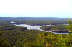
They extend roughly from La Cloche Provincial Park, south of Massey, to Killarney Provincial Park, southwest of Sudbury. The communities of West River, Willisville and Whitefish Falls are located directly within the range; the town of Espanola and the municipality of Killarney are located nearby, however they can be seen (from some vantage points) as far away as Manitoulin Island.

Ontario Highway 6 is the principal transportation route through the range.

Killarney Provincial Park is located in the range and is very popular among tourists. Another feature includes the "Heaven's Gate Trail" which traverses the length of the range from Willisville in the east to Massey in the west. Thought to be an old aboriginal trade route, it traverses the plateau of the range with the North Channel of Lake Huron visible to the south. The trail is particularly grueling and is rarely traversed mostly due to its length and remoteness from major cities.

Geology

With an estimated age of 1.88 billion years, the La Cloche Mountains consist of metamorphosed quartz sandstone, which accumulated and was deposited in the Georgian Bay region of Ontario 2.5 billion years ago. [2] The mountains themselves were formed during the Penokean Orogeny, a mountain-building stage in the Canadian Shield's geological history. [3] During this time, the sandstone that had accumulated was compressed and heated to form the white Quartzite which dominates the landscape today. The hills comprising the La Cloche Mountains are believed to have once been higher than today's Rocky Mountains, and were eroded down to their current altitude of 539 meters [4] at its peak. They remain among the highest altitudes in Ontario.

A southern extension of the La Cloche Mountains, the South La Cloche Mountains, extends to the south and juts into Georgian Bay along Badgeley Point, north of Killarney and Secondary Highway 637.

History

According to legend, the hills were warning bells, or tocsins, used by local First Nations for signaling. These "Bell Rocks" could be heard for a considerable distance when struck, and accordingly when voyageurs explored the area they named it with the French word for "bell" — La Cloche.

Camps

Images

Related Research Articles

<span class="mw-page-title-main">Killarney, Ontario</span> Municipality in Ontario, Canada

Killarney is a municipality located on the northern shore of Georgian Bay in the Sudbury District of Ontario, Canada. Killarney is commonly associated with Killarney Provincial Park, which is a large wilderness park located to the east of the townsite which occupies much of the municipality's expanded boundary. In addition to the community of Killarney itself, the communities of Hartley Bay and Bigwood, and the ghost towns of French River, Collins Inlet and Key Harbour, are also located within the municipal boundaries. The eastern end of the La Cloche Mountain Range is also located within the municipality of Killarney.

<span class="mw-page-title-main">Sudbury District</span> District in Ontario, Canada

The Sudbury District is a district in Northeastern Ontario in the Canadian province of Ontario. It was created in 1894 from townships of eastern Algoma District and west Nipissing District.

<span class="mw-page-title-main">Manitoulin District</span> District in Ontario, Canada

Manitoulin District is a district in Northeastern Ontario within the Canadian province of Ontario. It was created in 1888 from part of the Algoma District. The district seat is in Gore Bay.

<span class="mw-page-title-main">Killarney Provincial Park</span> Provincial park in Ontario, Canada

Killarney Provincial Park is a provincial park in central Ontario, Canada.

<span class="mw-page-title-main">North Channel (Ontario)</span>

The North Channel is the body of water along the north shore of Lake Huron, in the Canadian province of Ontario. It stretches approximately 160 nautical miles (300 km) and is bordered on the east by Georgian Bay, on the west by the St. Marys River, to the north by the eastern Algoma District and part of the Sudbury District, and to the south by the islands of Manitoulin, Cockburn, Drummond and St. Joseph. At its widest point it is over 30 km wide.

<span class="mw-page-title-main">Huron Central Railway</span> Railway in Ontario, Canada

The Huron Central Railway is a railway operating in northern Ontario, Canada. It is operated by Genesee & Wyoming Canada, the Canadian subsidiary of Genesee & Wyoming.

<span class="mw-page-title-main">Ontario Highway 68</span> Former Ontario provincial highway

King's Highway 68, commonly referred to as Highway 68, was a provincially maintained highway on Manitoulin Island, linking the island to the mainland. It was connected to the rest of the network at McKerrow, where it met Highway 17. The road was built in the 1920s as a trunk road for the Department of Northern Development, but was assumed as a provincial highway in 1937, as the only King's Highway on the island. Highway 68 stretched from South Baymouth in the south, through the towns of Manitowaning and Little Current north through Espanola on the mainland, before terminating at Highway 17 in McKerrow.

<span class="mw-page-title-main">La Cloche Silhouette Trail</span>

The La Cloche Silhouette Trail is a 78-kilometre (48 mi) backpacking loop across the white quartzite peaks of the La Cloche mountain range. The trail is situated in Killarney Provincial Park, Ontario, Canada. The trail is named for Group of Seven painter Franklin Carmichael's painting "La Cloche Silhouette." Wildlife can be seen throughout the trail - black bears, moose, wolverines, mountain lions, lynx, fishers, snakes, porcupines, beavers, river otters, among other animals, can be encountered at various points along the way.

<span class="mw-page-title-main">Whitefish River (Sudbury District)</span> River in Ontario, Canada

The Whitefish River is a river in Sudbury District in northeastern Ontario, Canada and a tributary of Lake Huron.

<span class="mw-page-title-main">Rainbow Country</span> Local Services Board in Ontario, Canada

Rainbow Country is a local services board in the Canadian province of Ontario. It encompasses and provides services to the communities of Whitefish Falls and Willisville in the Unorganized North Sudbury District and Birch Island and McGregor Bay in the Manitoulin District.

<span class="mw-page-title-main">Lake Mindemoya</span> Lake in Ontario, Canada

Lake Mindemoya is a lake in Ontario, Canada, located within Manitoulin Island which is the world's largest island in a freshwater lake. The lake is located near the town of Mindemoya, and it is the third largest on Manitoulin Island. It has a perimeter of 33.5 km, its marl clay base imparting to a deep blue to light green colour. The lake reaches depths of 21 m (69'), while the average depth is 7.3 m (24'); the surface area is 3,869 ha.

<span class="mw-page-title-main">Animikie Group</span> North American geologic group

The Animikie Group is a geologic group composed of sedimentary and metasedimentary rock, having been originally deposited between 2,500 and 1,800 million years ago during the Paleoproterozoic era, within the Animikie Basin. This group of formations is geographically divided into the Gunflint Range, the Mesabi and Vermilion ranges, and the Cuyuna Range. On the map, the Animikie Group is the dark gray northeast-trending belt which ranges from south-central Minnesota, U.S., up to Thunder Bay, Ontario, Canada. The Gunflint Iron Range is the linear black formation labeled G, the Mesabi Iron Range is the jagged black linear formation labeled F, and Cuyuna Iron Range is the two black spots labeled E. The gabbro of the Duluth Complex, intruded during the formation of the Midcontinent Rift, separates the Mesabi and Gunflint iron ranges; it is shown by the speckled area wrapping around the western end of Lake Superior.

Killarney Lakelands and Headwaters Provincial Park is a provincial park in central Ontario, Canada. Located primarily within the Sudbury District with a small portion located in the Walden area of Greater Sudbury, the park was created in 2006 as an expansion of the adjacent Killarney Provincial Park.

<span class="mw-page-title-main">Anishinabe Spiritual Centre</span> Church in Ontario, Canada

Anishinabe Spiritual Centre is a Roman Catholic centre for Ignatian spirituality and training in ministry run by the Society of Jesus in Espanola, Ontario, specifically for the local First Nation people in the area. It is situated to the south of Espanola, on the shore of Anderson Lake, just off Ontario Highway 6. Since it was founded, it has been the only place in northern Ontario that has offered Roman Catholic ministerial training to Aboriginal peoples in Canada.

<span class="mw-page-title-main">Silver Peak (Ontario)</span>

Silver Peak is a mountain located in the southern portion of the La Cloche Mountains at Killarney Provincial Park.

Point Grondine Park is a First Nations-owned nature park on the northern shore of Lake Huron in Sudbury District, Ontario, which occupies the unpopulated historic Point Grondine 3 Indian reserve. It is a ceded reserve of the Wiikwemkoong First Nation, having been reserved under the terms of the Robinson Huron Treaty in 1850.

<span class="mw-page-title-main">Geology of Utah</span>

The geology of Utah, in the western United States, includes rocks formed at the edge of the proto-North American continent during the Precambrian. A shallow marine sedimentary environment covered the region for much of the Paleozoic and Mesozoic, followed by dryland conditions, volcanism, and the formation of the basin and range terrain in the Cenozoic.

<span class="mw-page-title-main">La Cloche Provincial Park</span> Provincial park in Ontario, Canada

La Cloche Provincial Park is a provincial park at the boundary of Algoma and Sudbury Districts in Ontario, Canada. The park consists of an unspoiled section of the La Cloche Mountains that stretch along the North Channel of Georgian Bay, as well as several islands in the channel.

The Escarpment Biosphere Conservancy (EBC) is an environmental NGO, a registered environmental charity, and a qualified recipient to receive ecological gifts through the eco-gifts program of Environment and Climate Change Canada (Canada). It is the largest Ontario-focused land trust, with over 190 nature reserves as of January 2021.

The Crack is a 7.5-kilometre out-and-back trail found in Killarney Provincial Park in Ontario, Canada. It is known for the rough quartzite cliff in the mountain creating a formation resembling a crack filled with boulders, and the panoramic views of the mountains and lakes at the peak.

References

  1. Turner, Bob; Quat, Marianne; Debicki, Ruth; Thurston, Phil (2022-08-27). "Killarney" (PDF). Ontario.ca. Retrieved 2022-08-27.
  2. "UBC Press | Journey to the Ice Age - Discovering an Ancient World By Peter L. Storck". UBC Press. Retrieved 2018-07-11.
  3. Schulz, Klaus J.; Cannon, William F. (2007-08-01). "The Penokean orogeny in the Lake Superior region". Precambrian Research. 157 (1–4): 4–25. doi:10.1016/j.precamres.2007.02.022. ISSN   0301-9268.
  4. "Silver Peak". ontariohighpoints.com. Retrieved 2018-07-11.

Commons-logo.svg Media related to La Cloche Mountains at Wikimedia Commons