Granite is a coarse-grained (phaneritic) intrusive igneous rock composed mostly of quartz, alkali feldspar, and plagioclase. It forms from magma with a high content of silica and alkali metal oxides that slowly cools and solidifies underground. It is common in the continental crust of Earth, where it is found in igneous intrusions. These range in size from dikes only a few centimeters across to batholiths exposed over hundreds of square kilometers.

Breccia is a rock composed of large angular broken fragments of minerals or rocks cemented together by a fine-grained matrix.

Mount Royal is a mountain in the city of Montreal, immediately west of Downtown Montreal, Quebec, Canada. The city's name is thought to be derived from the mountain's name.

In geology, rock is any naturally occurring solid mass or aggregate of minerals or mineraloid matter. It is categorized by the minerals included, its chemical composition, and the way in which it is formed. Rocks form the Earth's outer solid layer, the crust, and most of its interior, except for the liquid outer core and pockets of magma in the asthenosphere. The study of rocks involves multiple subdisciplines of geology, including petrology and mineralogy. It may be limited to rocks found on Earth, or it may include planetary geology that studies the rocks of other celestial objects.
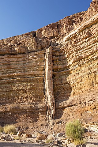
In geology, a dike or dyke is a sheet of rock that is formed in a fracture of a pre-existing rock body. Dikes can be either magmatic or sedimentary in origin. Magmatic dikes form when magma flows into a crack then solidifies as a sheet intrusion, either cutting across layers of rock or through a contiguous mass of rock. Clastic dikes are formed when sediment fills a pre-existing crack.

In geology, a sill is a tabular sheet intrusion that has intruded between older layers of sedimentary rock, beds of volcanic lava or tuff, or along the direction of foliation in metamorphic rock. A sill is a concordant intrusive sheet, meaning that it does not cut across preexisting rock beds. Stacking of sills builds a sill complex and a large magma chamber at high magma flux. In contrast, a dike is a discordant intrusive sheet, which does cut across older rocks.

The Monteregian Hills is a linear chain of isolated mountains in Montreal and Montérégie, between the Laurentians and the Appalachians.
A protolith is the original, unmetamorphosed rock from which a given metamorphic rock is formed.
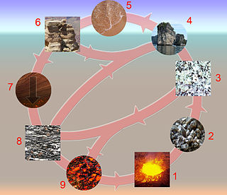
The rock cycle is a basic concept in geology that describes transitions through geologic time among the three main rock types: sedimentary, metamorphic, and igneous. Each rock type is altered when it is forced out of its equilibrium conditions. For example, an igneous rock such as basalt may break down and dissolve when exposed to the atmosphere, or melt as it is subducted under a continent. Due to the driving forces of the rock cycle, plate tectonics and the water cycle, rocks do not remain in equilibrium and change as they encounter new environments. The rock cycle explains how the three rock types are related to each other, and how processes change from one type to another over time. This cyclical aspect makes rock change a geologic cycle and, on planets containing life, a biogeochemical cycle.

Relative dating is the science of determining the relative order of past events, without necessarily determining their absolute age. In geology, rock or superficial deposits, fossils and lithologies can be used to correlate one stratigraphic column with another. Prior to the discovery of radiometric dating in the early 20th century, which provided a means of absolute dating, archaeologists and geologists used relative dating to determine ages of materials. Though relative dating can only determine the sequential order in which a series of events occurred, not when they occurred, it remains a useful technique. Relative dating by biostratigraphy is the preferred method in paleontology and is, in some respects, more accurate. The Law of Superposition, which states that older layers will be deeper in a site than more recent layers, was the summary outcome of 'relative dating' as observed in geology from the 17th century to the early 20th century.

Flow banding is a geological term to describe bands or layers that can sometimes be seen in rock that formed from magma.

In geology, texture or rock microstructure refers to the relationship between the materials of which a rock is composed. The broadest textural classes are crystalline, fragmental, aphanitic, and glassy. The geometric aspects and relations amongst the component particles or crystals are referred to as the crystallographic texture or preferred orientation. Textures can be quantified in many ways. A common parameter is the crystal size distribution. This creates the physical appearance or character of a rock, such as grain size, shape, arrangement, and other properties, at both the visible and microscopic scale.

In geology, an igneous intrusion is a body of intrusive igneous rock that forms by crystallization of magma slowly cooling below the surface of the Earth. Intrusions have a wide variety of forms and compositions, illustrated by examples like the Palisades Sill of New York and New Jersey; the Henry Mountains of Utah; the Bushveld Igneous Complex of South Africa; Shiprock in New Mexico; the Ardnamurchan intrusion in Scotland; and the Sierra Nevada Batholith of California.
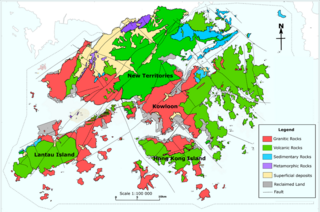
The geology of Hong Kong is dominated by igneous rocks formed during a major volcanic eruption period in the Mesozoic era. It made up 85% of Hong Kong's land surface and the remaining 15% are mostly sedimentary rocks located in the northeast New Territories. There are also a very small percentage of metamorphic rocks in the New Territories, formed by deformation of pre-existing sedimentary rocks (metamorphism).

Gaspésie National Park is a provincial park located south of the town of Sainte-Anne-des-Monts, Quebec, Canada in the inland of the Gaspé peninsula. The park contains the highest peak of the Appalachian Mountains in Canada, Mont Jacques-Cartier, 1,270 metres (4,170 ft) above sea level. In addition, the park contains the only population of Caribou found south of the Saint Lawrence River in Canada.

Crested Butte is a prominent mountain summit in the Elk Mountains range of the Rocky Mountains of North America. The 12,168-foot (3,709 m) peak is in Gunnison National Forest, 2.1 miles (3.4 km) northeast by east of the Town of Crested Butte in Gunnison County, Colorado, United States. Ski lifts and runs of the Crested Butte Mountain Resort occupy the north side of the mountain.
This glossary of geology is a list of definitions of terms and concepts relevant to geology, its sub-disciplines, and related fields. For other terms related to the Earth sciences, see Glossary of geography terms.

A peperite is a type of volcaniclastic rock consisting of sedimentary rock that contains fragments of younger igneous material and is formed when magma comes into contact with wet sediments. The term was originally used to describe rocks from the Limagne region of France, from the similarity in appearance of the granules of dark basalt in the light-coloured limestone to black pepper. Typically the igneous fragments are glassy and show chilled-margins to the sedimentary matrix, distinguishing them from clasts with a sedimentary origin.

Igneous rock, or magmatic rock, is one of the three main rock types, the others being sedimentary and metamorphic. Igneous rocks are formed through the cooling and solidification of magma or lava.