
Les Sources is a regional county municipality in the Estrie region of Quebec, Canada. The seat is the city of Val-des-Sources. Before April 22, 2006 it was known as Asbestos regional county municipality, and before August 1990 it was known as L'Or-Blanc regional county municipality.

Sutton is a town in southwestern Quebec. It is part of the Brome-Missisquoi Regional County Municipality in the administrative region of the Estrie. The population as of the Canada 2021 Census was 4,548. Historically, Sutton is considered to be part of the Eastern Townships.

Mount Gosford is a mountain located in southern Quebec, Canada, at the border with Maine. It lies entirely in Saint-Augustin-de-Woburn in Estrie and is part of the White Mountains of the Appalachians. It is named after Archibald Acheson, 2nd Earl of Gosford, governor general of British North America from 1835 to 1835. It is the 21st highest peak in Quebec and 4th in Southern Quebec.
Mont Albert is a mountain in the Chic-Choc range in the Gaspésie National Park in the Gaspé Peninsula of eastern Quebec, Canada. At 1,151 m (3,776 ft), it is one of the highest mountains in southern Quebec, and is popular for hiking.
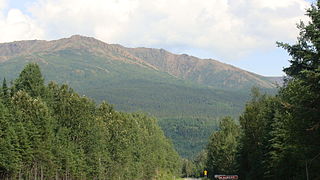
Mont Chapman is the highest peak in the Stoke Mountains of the southern Notre Dame mountain range located in Stoke, Quebec, Canada. It is accessible from trails maintained by Les Sentiers de l'Estrie. From the summit, one is able to see Mont Ham, Mont Ste-Cécile, and Mont Mégantic. Neighboring Bald Peak is accessible by these same trails.
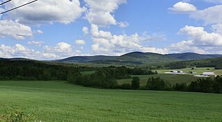
Mount Hereford is a mountain located in Coaticook Regional County Municipality, Estrie, Quebec, Canada. It rises to 864 metres (2,835 ft).
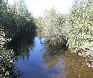
The Bernier River is a tributary of the Saint-François River. The "Bernier River" flows in the municipality of Stratford, in the Le Granit Regional County Municipality, in the administrative region of Estrie, in Quebec, in Canada.
The Nicolet Centre River is a tributary on the west bank of the Nicolet Southwest River. It flows into the municipality of Wotton, in the Les Sources Regional County Municipality (MRC), in the administrative region of Estrie, in Quebec, in Canada.

The Bergeron river is a tributary on the south shore of Lake Mégantic which flows into the Chaudière River; the latter flows northward to empty on the south shore of the St. Lawrence River.

Mount Pisgah is a mountain on the border between the Canadian province of Quebec, in the region of Estrie, and the American state of Maine, which is part of the Appalachian Mountains; it rises to 1,023 metres (3,356 ft) of altitude.

Mount Rider is a mountain in the municipality of Frontenac, in Le Granit Regional County Municipality, Estrie, in Quebec, in Canada. This mount is part of the Appalachian Mountains; its altitude is 660 meters (2,170 ft).

Mount Cliche is a mountain in Le Granit Regional County Municipality, in administrative region of Estrie, Quebec, in Canada. It is part of Appalachian Mountains; its altitude is 693 metres (2,274 ft).

The Parc régional des Appalaches is a regional park located in Montmagny Regional County Municipality in the region of Chaudière-Appalaches, in Quebec, Canada. This park includes lakes, forests, rivers, marshes, peat bogs and mountains.
The Parc régional du Massif-du-Sud is a regional park located in the heart of Massif du Sud, in Bellechasse Regional County Municipality and Les Etchemins Regional County Municipality, in Chaudière-Appalaches, in Quebec, in Canada.

The mont du Midi is a mountain in the Les Etchemins Regional County Municipality, near Saint-Luc-de-Bellechasse, in region of Chaudière-Appalaches, in Quebec, in Canada.
The mont Saint-Magloire is a mountain in the municipality of Saint-Philémon, Bellechasse Regional County Municipality, in region of Chaudière-Appalaches, in Quebec, in Canada.

The Parc régional du Mont-Ham is a regional park highlighting Mont Ham, culminating at 713 metres (2,339 ft). The park is located in the municipality of Ham-Sud, in the Cantons-de-l'Est, in the Les Sources Regional County Municipality, in administrative region of Estrie, in Quebec, in Canada.
The Marécage-des-Scots Regional Park is a regional park of Quebec inaugurated in ? and straddling the municipalities of Hampden and Scotstown, in Le Haut-Saint-François Regional County Municipality, in the administrative region of Estrie, in Quebec, Canada.
Mount Chocolat is a mountain located in Saint-Philémon, in the Bellechasse Regional County Municipality, in the administrative region of Chaudière-Appalaches, in Quebec, Canada.

