Ham-Sud

Last updated

Ham-Sud
Mont-Ham (Quebec).jpg
Saint-Joseph-de-Ham-Sud Quebec location diagram.png
Location within Les Sources RCM
Canada Southern Quebec location map.png
Red pog.svg
Ham-Sud
Location in southern Quebec
Coordinates: 45°45′40″N71°36′07″W / 45.761°N 71.602°W / 45.761; -71.602 [1]
CountryFlag of Canada (Pantone).svg  Canada
Province Flag of Quebec.svg  Quebec
Region Estrie
RCM Les Sources
ConstitutedJanuary 1, 1879
Named for West Ham [1]
Government
[2]
  MayorLangevin Gagnon
   Federal riding Richmond—Arthabaska
   Prov. riding Richmond
Area
  Total152.40 km2 (58.84 sq mi)
  Land151.21 km2 (58.38 sq mi)
Population
 (2021) [3]
  Total214
  Density1.4/km2 (4/sq mi)
  Pop 2016-2021
Decrease2.svg 8.9%
Time zone UTC−5 (EST)
  Summer (DST) UTC−4 (EDT)
Postal code(s)
Area code 819
HighwaysQc257.svg R-257
Website ham-sud.ca OOjs UI icon edit-ltr-progressive.svg

Ham-Sud is a municipality in Quebec, Canada.

Prior to October 22, 2011 it was a parish municipality and its name was Saint-Joseph-de-Ham-Sud. [4] It lies 20 kilometres (12 mi) to the east of Wotton and about 50 kilometres (31 mi) to the southwest of Thetford Mines. Quebec Route 257 passes through the region.

Contents

Colonized in the middle of the 19th century, the township of Ham-Sud, established in 1851, takes its name from a village in the county of Essex in England. One of its first inhabitants, Joseph Dion, would eventually see his first name honoured through attribution to the mission in 1869. The parish was established both canonically and civilly in 1877. The parish municipality, installed two years later, would also take this denomination, Saint-Joseph-de-Ham-Sud. [5]

History

On 22 Oct. 2011, the parish municipality of Saint-Joseph-de-Ham-Sud changed its name and status to simply Municipality of Ham-Sud. [6]

Demography

The 2021 census counted 214 inhabitants, which is a 8.9% decrease from 2016. [3]

Related Research Articles

<span class="mw-page-title-main">La Haute-Côte-Nord Regional County Municipality</span> Regional county municipality in Quebec, Canada

La Haute-Côte-Nord is a regional county municipality in northeastern Quebec, Canada, in the Côte-Nord region. It is located on the Gulf of Saint Lawrence where the Saguenay River flows into it. The seat is Les Escoumins. The municipality has a land area of 11,612.68 square kilometres (4,483.68 sq mi) and its population was 10,846 inhabitants as of the 2016 census. Its largest community is the city of Forestville.

<span class="mw-page-title-main">Papineauville</span> Municipality in Quebec, Canada

Papineauville is a town and municipality in the Outaouais region of Quebec, Canada. It is the seat of the Papineau Regional County Municipality. In 2001 its population was 2247.

<span class="mw-page-title-main">Saint-Joseph-de-Beauce</span> City in Quebec, Canada

Saint-Joseph-de-Beauce is a city in the Municipalité régionale de comté Beauce-Centre in Quebec, Canada. It is part of the Chaudière-Appalaches region and the population was 5,014 as of the Canada 2021 Census.

<span class="mw-page-title-main">Saint-Évariste-de-Forsyth, Quebec</span> Place in Quebec, Canada

Saint-Évariste-de-Forsyth was a municipality in the Municipalité régionale de comté de Beauce-Sartigan in Quebec, Canada. It was part of the Chaudière-Appalaches region and the population is 647 at the 2006 census.

<span class="mw-page-title-main">Saint-Basile, Quebec</span> City in Quebec, Canada

Saint-Basile is a municipality situated in Portneuf Regional County Municipality in the Canadian province of Quebec.

<span class="mw-page-title-main">Saint-Édouard-de-Fabre</span> Parish municipality in Quebec, Canada

Saint-Édouard-de-Fabre is a parish municipality in western Quebec, Canada, in the Témiscamingue Regional County Municipality.
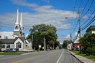
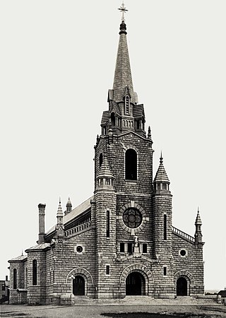
<span class="mw-page-title-main">Saint-Joseph-de-Kamouraska</span> Parish municipality in Quebec, Canada

Saint-Joseph-de-Kamouraska is a parish municipality in the Canadian province of Quebec, located in the Kamouraska Regional County Municipality.
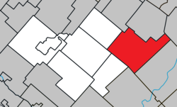
<span class="mw-page-title-main">Saint-Antonin, Quebec</span> City in Quebec, Canada

Saint-Antonin is a city in the Bas-Saint-Laurent region of Quebec, Canada, a few kilometres south of the city of Rivière-du-Loup, in Rivière-du-Loup Regional County Municipality. The municipality is named after Louis-Antonin or Antoine Proulx (1810-1896), priest of Fraserville (Rivière-du-Loup) and was founded in 1856.

<span class="mw-page-title-main">Notre-Dame-des-Sept-Douleurs, Quebec</span> Parish municipality in Quebec, Canada

Notre-Dame-des-Sept-Douleurs is an island municipality in the Bas-Saint-Laurent region of Quebec, Canada, part of the Rivière-du-Loup Regional County Municipality. It is located on and contiguous with Île Verte in the Estuary of St. Lawrence, about 20 kilometres (12 mi) north-east of Rivière-du-Loup. The name Île Verte was given in 1621 by Samuel de Champlain written "Isle Verte".

<span class="mw-page-title-main">Saint-Joseph-du-Lac</span> Municipality in Quebec, Canada

Saint-Joseph-du-Lac is a municipality in the Laurentides region of Quebec, Canada, part of the Deux-Montagnes Regional County Municipality.

<span class="mw-page-title-main">Saint-Hilaire-de-Dorset</span> Parish municipality in Quebec, Canada

Saint-Hilaire-de-Dorset is a parish municipality in the Beauce-Sartigan Regional County Municipality in the Chaudière-Appalaches region of Quebec, Canada.

<span class="mw-page-title-main">Saint-Camille-de-Lellis, Quebec</span> Parish municipality in Quebec, Canada

Saint-Camille-de-Lellis is a parish in the Les Etchemins Regional County Municipality in Quebec, Canada. It is part of the Chaudière-Appalaches region and the population is 752 as of the Canada 2016 Census. It is named after Saint Camillus de Lellis, but also commemorates Reverend Camille-Stanislas Brochu, first priest of the parish.

<span class="mw-page-title-main">Sainte-Marie, Quebec</span> City in Quebec, Canada

Sainte-Marie is a city in the province of Quebec, Canada. It is the seat of the Municipalité régionale de la Nouvelle-Beauce, in Chaudière-Appalaches. The population was 13,134 as of the Canada 2021 Census, and was 95.7% French-speaking as of 2021. It is located 59 kilometres (37 mi) south-east of Quebec City, on the Chaudière River.

<span class="mw-page-title-main">Saint-Thomas, Quebec</span> Municipality in Quebec, Canada

Saint-Thomas is a town in Joliette Regional County Municipality in the Lanaudière region of Quebec, Canada.

<span class="mw-page-title-main">Saint-Donat, Bas-Saint-Laurent, Quebec</span> Parish municipality in Quebec, Canada

Saint-Donat is a parish municipality in La Mitis Regional County Municipality in the Bas-Saint-Laurent region of Quebec, Canada. Its population in the Canada 2021 Census was 835.

<span class="mw-page-title-main">Saint-Joseph-de-Lepage</span> Parish municipality in Quebec, Canada

Saint-Joseph-de-Lepage is a parish municipality in La Mitis Regional County Municipality in the Bas-Saint-Laurent region of Quebec, Canada.

<span class="mw-page-title-main">Sainte-Flavie, Quebec</span> Parish municipality in Quebec, Canada

Sainte-Flavie is a parish municipality in the La Mitis Regional County Municipality of Quebec, Canada, located on the south shore of the Saint Lawrence River, about 3 km (2 mi) northwest of Mont-Joli. It is named after Flavia, a martyred saint.

<span class="mw-page-title-main">Saint-Aubert, Quebec</span> Municipality in Quebec, Canada

Saint-Aubert is a municipality in Quebec, situated in the L'Islet Regional County Municipality and the Chaudière-Appalaches administrative region. Saint-Aubert lies in the Côte-du-Sud federal electoral district.

<span class="mw-page-title-main">Saint-Pierre-de-la-Rivière-du-Sud, Quebec</span> Parish municipality in Quebec, Canada

Saint-Pierre-de-la-Rivière-du-Sud is a parish municipality in Quebec.

<span class="mw-page-title-main">Carleton-sur-Mer</span> City in Quebec, Canada

Carleton-sur-Mer is the fifth largest town of the Gaspésie's south shore, in southeastern Quebec, Canada, located on Route 132, along Chaleur Bay. It is the seat of the Avignon Regional County Municipality.

References

  1. 1 2 "Banque de noms de lieux du Québec: Reference number 359444". toponymie.gouv.qc.ca (in French). Commission de toponymie du Québec.
  2. 1 2 "Répertoire des municipalités: Geographic code 40005". www.mamh.gouv.qc.ca (in French). Ministère des Affaires municipales et de l'Habitation.
  3. 1 2 3 https://www12.statcan.gc.ca/census-recensement/2021/dp-pd/prof/details/page.cfm?Lang=E&SearchText=Ham%2Dsud&DGUIDlist=2021A00052440005&GENDERlist=1,2,3&STATISTIClist=1,4&HEADERlist=0
  4. http://www.stat.gouv.qc.ca/publications/referenc/pdf2011/modif_oct11.pdf%5B%5D
  5. "Toponymie : Saint-Joseph-de-Ham-Sud" (in French).
  6. "Modifications aux municipalités du Québec" (PDF) (in French). Institut de la statistique du Québec. October 2011. p. 3. ISSN   1715-6408.[ permanent dead link ]