
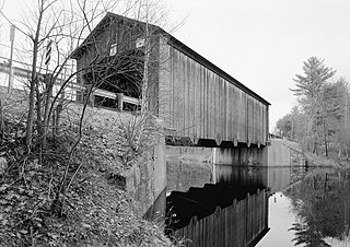
The Columbia Bridge is a covered bridge, carrying Columbia Bridge Road over the Connecticut River between Columbia, New Hampshire and Lemington, Vermont. Built in 1911–12, it is one of only two New Hampshire bridges built with Howe trusses, and is one of the last covered bridges built in the historic era of covered bridge construction in both states. It was listed on the National Register of Historic Places in 1976.

The Blow-Me-Down Covered Bridge is a historic wooden covered bridge carrying Lang Road over Blow-me-down Brook in the town of Cornish, near its northern border with Plainfield, New Hampshire. Built in 1877, the kingpost structure is one of the state's few surviving 19th-century covered bridges. The bridge was listed on the National Register of Historic Places in 1978.

The Whittier Bridge is a historic wooden covered bridge in Ossipee, New Hampshire. The bridge carried an old alignment of New Hampshire Route 25 over the Bearcamp River. Built in 1870, it is one of New Hampshire's few surviving 19th-century covered bridges, and a rare example of a Paddleford truss. The bridge was listed on the National Register of Historic Places in 1984. It was closed to vehicular traffic in 1989, and was removed from its footings for restoration in 2008. As of September 2019, the bridge is resting on Nudd Road adjacent to the crossing point. It was placed back on its abutments in the late fall of 2022.

The Cedar Swamp Covered Bridge, also known as the Station Bridge and by various other names, was a historic wooden covered bridge spanning Otter Creek between Cornwall and Salisbury, Vermont. The Town lattice truss bridge was built in 1864-1865 and added to the National Register of Historic Places in 1974. It was destroyed by fire in September 2016.

Comstock's Bridge, also known as the Comstock Covered Bridge, is a covered bridge in Connecticut, connecting the town of East Hampton to the town of Colchester, spanning the Salmon River. First built in 1840, but entirely replaced in 1873, it is one of only three historical covered bridges in the state. It is open to pedestrian traffic in a small park off Comstock Bridge Road. The bridge was listed on the National Register of Historic Places on January 1, 1976.
The Hancock–Greenfield Bridge is a historic covered bridge carrying Forest Road over the Contoocook River at the town line between Hancock and Greenfield, New Hampshire. The New Hampshire Department of Transportation covered bridge database refers to it as County Bridge. Built in 1937, it is the first wooden covered bridge in the northeastern United States to use modern engineering techniques. The bridge was listed on the National Register of Historic Places in 1981.

The Capon Lake Whipple Truss Bridge, formerly known as South Branch Bridge or Romney Bridge, is a historic Whipple truss bridge in Capon Lake, West Virginia. It is located off Carpers Pike and crosses the Cacapon River. The bridge formerly carried Capon Springs Road over the river, connecting Capon Springs and Capon Lake.
The Goffstown Covered Railroad Bridge was a rare railroad covered bridge in Goffstown, New Hampshire. It was built in 1901 by the Boston and Maine Railroad, on the site of an earlier bridge built in 1850 by the New Hampshire Central Railroad, and carried its tracks across the Piscataquog River in the center of Goffstown. The bridge was listed on the National Register of Historic Places in 1975. It was destroyed by arson in 1976, as would later be the case with the Hillsborough Railroad Bridge in 1985.
Wright's Bridge is a historic covered bridge in Newport, New Hampshire. Originally built in 1906 to carry the Boston and Maine Railroad across the Sugar River, it now carries the multi-use Sugar River Trail. The bridge was listed on the National Register of Historic Places in 1975.
The Bennett Bridge is a historic covered bridge in rural northern Oxford County, Maine. The bridge, now closed to traffic, formerly carried Littlehale Road over the Magalloway River, about 1.5 miles (2.4 km) south of the village Wilsons Mills in Lincoln Plantation. Built in 1901, it is one of Maine's few older covered bridges. The bridge was listed on the National Register of Historic Places in 1970.

The Hemlock Bridge is a covered bridge in a rural part of Fryeburg, Maine. Built in 1857, it carries Hemlock Bridge Road over the Old Course Saco River, near the western shore of Kezar Lake in eastern Fryeburg. It is the last surviving 19th-century covered in Fryeburg. It was listed on the National Register of Historic Places in 1970 and designated as a Maine Historic Civil Engineering Landmark by the American Society of Civil Engineers in 2002.

Babb's Bridge is a covered bridge spanning the Presumpscot River on Hurricane Road, between the towns of Gorham and Windham in Cumberland County, Maine. Built in 1976, it is a replica of a 19th-century bridge that stood on the site until destroyed by arson in 1973. The bridge was listed on the National Register of Historic Places in 1972, and was delisted in 2023.

The Porter-Parsonsfield Bridge is a covered bridge in western Maine, and one of the few 19th-century covered bridges left in the state. The bridge spans the Ossipee River just east of the modern alignment of North Road, which it formerly carried, between the towns of Porter and Parsonsfield. Built in 1876 by the towns, it is a Paddleford truss bridge which has been strengthened with laminated arches. The bridge was closed to traffic in 1960, and is now maintained by the state. It was listed on the National Register of Historic Places in 1970.

The Waterman Covered Bridge was an historic covered bridge in Johnson, Vermont that carried Waterman Road across Waterman Creek. Built in 1868, it was one of three surviving 19th-century bridges in the town. It was listed on the National Register of Historic Places in 1974, and collapsed in January 1982.

The Sunday River Bridge, also known locally as the Artists Bridge, is a historic covered bridge in Newry, Maine. It is located northeast of the Sunday River Ski Resort, adjacent to the crossing of the Sunday River by Sunday River Road, which the bridge formerly carried. Built in 1872, it is one of Maine's few surviving 19th-century covered bridges. The bridge was listed on the National Register of Historic Places in 1970.

The Robyville Bridge is a historic covered bridge in Corinth, Maine. Built in 1876, this Howe truss bridge is one of the state's few surviving 19th-century covered bridges. It carries Covered Bridge Road across Kenduskeag Stream in the southern part of the rural community. It was listed on the National Register of Historic Places in 1970 and designated as a Maine Historic Civil Engineering Landmark by the American Society of Civil Engineers in 2002.

The Iron Bridge at Howard Hill Road is a modern pony truss bridge, carrying Howard Hill Road across the Black River in southeastern Cavendish, Vermont. It is the replacement for a historic 1890 Pratt through truss bridge, which is now in storage. The historic bridge was listed on the National Register of Historic Places in 1982.

The Quechee Gorge Bridge is a historic bridge, carrying U.S. Route 4 (US 4) across Quechee Gorge, near the Quechee village of Hartford, Vermont. Built in 1911, it is Vermont's oldest surviving steel arch bridge. It was listed on the National Register of Historic Places in 1990.

The East Shoreham Covered Railroad Bridge is a historic covered bridge spanning the Lemon Fair River near East Shoreham, Vermont. Built in 1897 by the Rutland Railroad Company, it is the state's only surviving example of a wooden Howe truss railroad bridge. It was listed on the National Register of Historic Places in 1974.

The Greenbanks Hollow Covered Bridge is a historic covered bridge, carrying Greenbanks Hollow Road across Joes Brook in southern Danville, Vermont. It is the only surviving 19th-century covered bridge in the town. It was listed on the National Register of Historic Places in 1974.


