National Register of Historic Places listings in Aroostook County, Maine

Last updated

Location of Aroostook County in Maine Map of Maine highlighting Aroostook County.svg
Location of Aroostook County in Maine

This is a list of the National Register of Historic Places listings in Aroostook County, Maine.

Contents

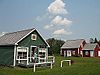
This is intended to be a complete list of the properties and districts on the National Register of Historic Places in Aroostook County, Maine, United States. Latitude and longitude coordinates are provided for many National Register properties and districts; these locations may be seen together in a map. [1]

There are 57 properties and districts listed on the National Register in the county, including 1 National Historic Landmark. Eight properties were once listed, but have since been removed.


    This National Park Service list is complete through NPS recent listings posted March 17, 2023. [2]

Map all coordinates using: OpenStreetMap  
Download coordinates as: KML
Contents: Counties in Maine  
Androscoggin - Aroostook - Cumberland - Franklin - Hancock - Kennebec - Knox - Lincoln - Oxford - Penobscot - Piscataquis - Sagadahoc - Somerset - Waldo - Washington - York

Current listings

[3] Name on the Register [4] ImageDate listed [5] Location City or townDescription
1 Acadian Historic Buildings
Acadian Historic Buildings VanBurenME AcadianVillage.jpg
Acadian Historic Buildings
December 13, 1977
(#77000062)
North of Van Buren on U.S. Route 1
47°12′17″N67°59′26″W / 47.204722°N 67.990556°W / 47.204722; -67.990556 (Acadian Historic Buildings)
Van Buren Buildings at the Acadian Village Museum
2 Acadian Landing Site
Acadian Landing Site MadawaskaME AcadianLandingCross.jpg
Acadian Landing Site
September 20, 1973
(#73000098)
East of Madawaska on the St. John River off U.S. Route 1
47°21′10″N68°16′23″W / 47.3528°N 68.2731°W / 47.3528; -68.2731 (Acadian Landing Site)
Madawaska
3 Amazeen House September 11, 1986
(#86002470)
15 Weeks St.
46°07′08″N67°50′17″W / 46.118889°N 67.838056°W / 46.118889; -67.838056 (Amazeen House)
Houlton
4 Anderson Bros. Store January 11, 2001
(#00001635)
280 Main St.
47°02′20″N68°08′28″W / 47.038889°N 68.141111°W / 47.038889; -68.141111 (Anderson Bros. Store)
Stockholm
5 Aroostook County Courthouse and Jail
Aroostook County Courthouse and Jail HoultonME AroostookCountyCourthouse.jpg
Aroostook County Courthouse and Jail
January 26, 1990
(#89002340)
Court St.
46°07′29″N67°50′23″W / 46.124722°N 67.839722°W / 46.124722; -67.839722 (Aroostook County Courthouse and Jail)
Houlton
6 Big Black Site
Big Black Site Big Black Site Aroostook Maine.jpg
Big Black Site
September 9, 1975
(#75000090)
Address Restricted
Eagle Lake
7 Bridgewater Town Hall and Jail January 26, 1990
(#89002339)
U.S. Route 1
46°14′45″N67°50′50″W / 46.245833°N 67.847222°W / 46.245833; -67.847222 (Bridgewater Town Hall and Jail)
Bridgewater
8 Cary Library
Cary Library Cary Library, Houlton, ME.jpg
Cary Library
June 25, 1987
(#87000929)
107 Main St.
46°07′31″N67°50′17″W / 46.125278°N 67.838056°W / 46.125278; -67.838056 (Cary Library)
Houlton
9 Church of the Advent June 21, 1991
(#91000767)
Church St., 1 block south of its junction with State Route 229
46°54′38″N67°49′30″W / 46.910556°N 67.825°W / 46.910556; -67.825 (Church of the Advent)
Limestone
10 Nicholas P. Clase House October 16, 1989
(#89001699)
Capitol Hill Rd.
46°56′30″N68°07′22″W / 46.941667°N 68.122778°W / 46.941667; -68.122778 (Nicholas P. Clase House)
New Sweden
11 Edward L. Cleveland House June 12, 1987
(#87000939)
87 Court St.
46°07′02″N67°50′28″W / 46.117222°N 67.841111°W / 46.117222; -67.841111 (Edward L. Cleveland House)
Houlton
12 Jean-Baptiste Daigle House October 16, 2013
(#13000833)
4 Dube St.
47°15′30″N68°35′23″W / 47.258238°N 68.58978°W / 47.258238; -68.58978 (Jean-Baptiste Daigle House)
Fort Kent
13 Donovan-Hussey Farms Historic District February 13, 2009
(#09000012)
546 and 535 Ludlow Rd.
46°08′50″N67°53′32″W / 46.1472°N 67.8921°W / 46.1472; -67.8921 (Donovan-Hussey Farms Historic District)
Houlton
14 Beecher H. Duncan Farm February 11, 2009
(#09000011)
26 Shorey Rd.
46°35′38″N67°58′59″W / 46.593972°N 67.982977°W / 46.593972; -67.982977 (Beecher H. Duncan Farm)
Westfield
15 The Elms July 22, 2009
(#09000549)
59 Court St.
46°07′18″N67°50′24″W / 46.121567°N 67.839878°W / 46.121567; -67.839878 (The Elms)
Houlton
16 First National Bank of Houlton September 20, 1973
(#73000099)
Market Sq.
46°07′25″N67°50′42″W / 46.123611°N 67.845°W / 46.123611; -67.845 (First National Bank of Houlton)
Houlton
17 Former Town Office and Jail April 4, 2019
(#100003587)
47 Burleigh St.
46°00′36″N68°16′08″W / 46.0099°N 68.2690°W / 46.0099; -68.2690 (Former Town Office and Jail)
Island Falls
18 Fort Fairfield Public Library
Fort Fairfield Public Library Carnegie Library, Fort Fairfield, ME.jpg
Fort Fairfield Public Library
January 5, 1989
(#88003021)
Main St.
46°46′20″N67°50′04″W / 46.772222°N 67.834444°W / 46.772222; -67.834444 (Fort Fairfield Public Library)
Fort Fairfield
19 Fort Kent
Fort Kent Fort Kent, Fort Kent (Aroostock County, Maine).jpg
Fort Kent
December 1, 1969
(#69000005)
At the confluence of Fish and St. John Rivers
47°15′10″N68°35′42″W / 47.2528°N 68.5951°W / 47.2528; -68.5951 (Fort Kent)
Fort Kent
20 Fort Kent Railroad Station
Fort Kent Railroad Station NPS FortKentRRStation.jpg
Fort Kent Railroad Station
April 21, 1989
(#89000249)
Junction of Main and Market Sts.
47°15′27″N68°35′23″W / 47.2575°N 68.5897°W / 47.2575; -68.5897 (Fort Kent Railroad Station)
Fort Kent
21 Freeman Barn January 17, 2017
(#100000522)
1533 Aroostook Rd.
47°09′21″N68°35′30″W / 47.155923°N 68.591668°W / 47.155923; -68.591668 (Freeman Barn)
Wallagrass
22 Frenchville Railroad Station and Water Tank June 20, 1995
(#95000723)
308 U.S. Route 1
47°16′47″N68°23′20″W / 47.279722°N 68.388889°W / 47.279722; -68.388889 (Frenchville Railroad Station and Water Tank)
Frenchville
23 Governor Brann School
Governor Brann School VanBurenME BrannSchoolhouse.jpg
Governor Brann School
December 23, 1993
(#93001432)
Eastern side of U.S. Route 1, 1.25 miles south of its junction with Madore Rd.
47°07′18″N67°57′42″W / 47.1216°N 67.9617°W / 47.1216; -67.9617 (Governor Brann School)
Cyr Plantation Listed in Van Buren; building is town hall of Cyr Plantation.
24 Gray Memorial United Methodist Church and Parsonage
Gray Memorial United Methodist Church and Parsonage Gray Memorial United Methodist Church and Parsonage.jpg
Gray Memorial United Methodist Church and Parsonage
June 20, 1995
(#95000725)
8 Prospect St.
46°51′37″N68°01′02″W / 46.860278°N 68.017222°W / 46.860278; -68.017222 (Gray Memorial United Methodist Church and Parsonage)
Caribou
25 Gustaf Adolph Lutheran Church
Gustaf Adolph Lutheran Church Gustaf Adolph Lutheran Church1.jpg
Gustaf Adolph Lutheran Church
June 20, 1997
(#97000608)
Eastern side of Capitol Hill Rd., 0.5 miles north of its junction with State Route 161
46°56′19″N68°07′14″W / 46.938611°N 68.120556°W / 46.938611; -68.120556 (Gustaf Adolph Lutheran Church)
New Sweden
26 Island Falls Opera House
Island Falls Opera House IslandFallsME OperaHouse.jpg
Island Falls Opera House
July 19, 1984
(#84001359)
Patten Rd. and Sewall St.
46°00′31″N68°16′13″W / 46.008611°N 68.270278°W / 46.008611; -68.270278 (Island Falls Opera House)
Island Falls
27 Pehr J. Jacobson House February 7, 2007
(#07000013)
452 New Sweden Rd.
46°57′14″N68°08′31″W / 46.953889°N 68.141944°W / 46.953889; -68.141944 (Pehr J. Jacobson House)
New Sweden
28 Larsson-Noak Historic District July 26, 1989
(#89000847)
Station Rd. northeast of New Sweden
46°56′48″N68°06′15″W / 46.946667°N 68.104167°W / 46.946667; -68.104167 (Larsson-Noak Historic District)
New Sweden
29 A. B. Leavitt House June 20, 1986
(#86001336)
State Route 158
45°52′22″N68°23′21″W / 45.872778°N 68.389167°W / 45.872778; -68.389167 (A. B. Leavitt House)
Sherman
30 Walter P. Mansur House
Walter P. Mansur House Walter Mansur House, Houlton, Maine.jpg
Walter P. Mansur House
February 9, 1990
(#89002342)
10 Water St.
46°07′35″N67°50′26″W / 46.126389°N 67.840556°W / 46.126389; -67.840556 (Walter P. Mansur House)
Houlton
31 Maple Grove Friends Church July 5, 2000
(#00000764)
Western side of U.S. Route 1A, 0.25 miles north of its junction with Upcountry (Fairmount Rd.)
46°42′21″N67°52′13″W / 46.705833°N 67.870278°W / 46.705833; -67.870278 (Maple Grove Friends Church)
Maple Grove
32 Market Square Historic District
Market Square Historic District HoultonME MarketSquare.jpg
Market Square Historic District
June 22, 1980
(#80000214)
Market Sq. and Main, Water, and Court Sts.
46°07′34″N67°50′24″W / 46.126111°N 67.84°W / 46.126111; -67.84 (Market Square Historic District)
Houlton
33 Isaie and Scholastique Martin House
Isaie and Scholastique Martin House Martin Acadian Homestead.jpg
Isaie and Scholastique Martin House
December 23, 2009
(#09001147)
137 Saint Catherine St.
47°21′17″N68°20′16″W / 47.3548°N 68.3379°W / 47.3548; -68.3379 (Isaie and Scholastique Martin House)
Madawaska
34 Fortunat O. Michaud House January 26, 1990
(#89002343)
231 Main St.
47°09′28″N67°56′16″W / 47.157778°N 67.937778°W / 47.157778; -67.937778 (Fortunat O. Michaud House)
Van Buren
35 Monticello Grange No. 338 July 5, 2000
(#00000760)
Main St., 0.7 miles south of its junction with Muckatee Rd.
46°18′26″N67°50′29″W / 46.307222°N 67.841389°W / 46.307222; -67.841389 (Monticello Grange No. 338)
Monticello
36 Oakfield Station
Oakfield Station Oakfield-train-station.jpg
Oakfield Station
June 25, 1987
(#87000928)
Station St.
46°05′52″N68°09′21″W / 46.097778°N 68.155833°W / 46.097778; -68.155833 (Oakfield Station)
Oakfield
37 Anders and Johanna Olsson Farm March 7, 1996
(#96000245)
114 West-Lebanon Rd.
46°57′56″N68°10′03″W / 46.9656°N 68.1675°W / 46.9656; -68.1675 (Anders and Johanna Olsson Farm)
New Sweden
38 Our Lady of Mount Carmel Catholic Church
Our Lady of Mount Carmel Catholic Church Mont Carmel, Grand Isle.jpg
Our Lady of Mount Carmel Catholic Church
October 15, 1973
(#73000100)
U.S. Route 1
47°16′45″N68°06′29″W / 47.279167°N 68.108056°W / 47.279167; -68.108056 (Our Lady of Mount Carmel Catholic Church)
Grand Isle Home to the Musée Culturel du Mont-Carmel
39 Presque Isle National Bank July 31, 1986
(#86002106)
422 Main St.
46°40′49″N68°00′56″W / 46.680278°N 68.015556°W / 46.680278; -68.015556 (Presque Isle National Bank)
Presque Isle
40 Blackhawk Putnam Tavern
Blackhawk Putnam Tavern HoultonME BlackhawkPutnamTavern.jpg
Blackhawk Putnam Tavern
January 30, 1976
(#76000087)
22 North St.
46°07′43″N67°50′37″W / 46.128611°N 67.843611°W / 46.128611; -67.843611 (Blackhawk Putnam Tavern)
Houlton
41 Reed School November 29, 2001
(#01001270)
U.S. Route 1, 0.1 miles south of its junction with Lycette Rd.
45°56′26″N67°49′49″W / 45.940556°N 67.830278°W / 45.940556; -67.830278 (Reed School)
North Amity
42 Philo Reed House
Philo Reed House ReedHouseFortFairfieldME.jpg
Philo Reed House
April 4, 1986
(#86000673)
38 Main St.
46°46′03″N67°49′12″W / 46.7675°N 67.82°W / 46.7675; -67.82 (Philo Reed House)
Fort Fairfield
43 Roosevelt School June 27, 2007
(#07000598)
Eastern side of U.S. Route 1A
47°07′08″N67°53′35″W / 47.118889°N 67.893056°W / 47.118889; -67.893056 (Roosevelt School)
Hamlin
44 Roosevelt School December 17, 1992
(#92001706)
Southern side of State Route 161 0.1 miles east of private road 861
47°12′31″N68°48′19″W / 47.208611°N 68.805278°W / 47.208611; -68.805278 (Roosevelt School)
St. John Plantation
45 St. David Catholic Church
St. David Catholic Church MadawaskaME StDavidCatholicChurch.jpg
St. David Catholic Church
October 2, 1973
(#73000101)
East of Madawaska on U.S. Route 1
47°20′57″N68°16′39″W / 47.349167°N 68.2775°W / 47.349167; -68.2775 (St. David Catholic Church)
Madawaska
46 St. John Catholic Church February 12, 2003
(#03000017)
St. John Rd.
47°13′12″N68°45′50″W / 47.2199°N 68.7638°W / 47.2199; -68.7638 (St. John Catholic Church)
St. John Plantation
47 William Sewall House
William Sewall House SewallHouseIslandFallsME.jpg
William Sewall House
April 12, 1982
(#82000740)
1027 Crystal Road
46°00′30″N68°16′11″W / 46.008333°N 68.269722°W / 46.008333; -68.269722 (William Sewall House)
Island Falls
48 John J. and Martha Sodergren Homestead January 4, 2007
(#06001222)
ME 161
47°02′11″N68°10′34″W / 47.036389°N 68.176111°W / 47.036389; -68.176111 (John J. and Martha Sodergren Homestead)
Stockholm
49 Sunset Lodge November 10, 1994
(#94001304)
0.5 miles south of State Route 161, on the eastern shore of Madawaska Lake
47°01′52″N68°11′36″W / 47.031111°N 68.193333°W / 47.031111; -68.193333 (Sunset Lodge)
Stockholm
50 Timmerhuset August 23, 1973
(#73000102)
Jemtland Rd.
46°57′10″N68°08′43″W / 46.952778°N 68.145278°W / 46.952778; -68.145278 (Timmerhuset)
New Sweden
51 Unitarian Church of Houlton
Unitarian Church of Houlton Unitarian Church of Houlton, Houlton, Maine.jpg
Unitarian Church of Houlton
June 25, 1987
(#87000945)
Military St.
46°07′27″N67°50′15″W / 46.124167°N 67.8375°W / 46.124167; -67.8375 (Unitarian Church of Houlton)
Houlton
52 U.S. Inspection Station-Fort Fairfield, Maine
U.S. Inspection Station-Fort Fairfield, Maine Fort Fairfield Maine Border Station - panoramio.jpg
U.S. Inspection Station-Fort Fairfield, Maine
September 10, 2014
(#14000555)
Boundaryline Rd.
46°45′57″N67°47′24″W / 46.7658°N 67.7901°W / 46.7658; -67.7901 (U.S. Inspection Station-Fort Fairfield, Maine)
Fort Fairfield
53 U.S. Inspection Station-Limestone, Maine
U.S. Inspection Station-Limestone, Maine Limestone Maine Border Station - panoramio.jpg
U.S. Inspection Station-Limestone, Maine
September 10, 2014
(#14000556)
ME 229
46°55′29″N67°47′24″W / 46.9247°N 67.79°W / 46.9247; -67.79 (U.S. Inspection Station-Limestone, Maine)
Limestone
54 U.S. Inspection Station-Orient, Maine
U.S. Inspection Station-Orient, Maine Orient Maine Border Station - panoramio.jpg
U.S. Inspection Station-Orient, Maine
September 10, 2014
(#14000557)
Boundary Line Road
45°49′01″N67°46′53″W / 45.8170°N 67.7815°W / 45.8170; -67.7815 (U.S. Inspection Station-Orient, Maine)
Orient
55 US Post Office-Presque Isle Main May 9, 1986
(#86001034)
23 2nd St.
46°40′53″N68°01′07″W / 46.681389°N 68.018611°W / 46.681389; -68.018611 (US Post Office-Presque Isle Main)
Presque Isle
56 White Memorial Building January 15, 1980
(#80000376)
109 Main St.
46°07′33″N67°50′17″W / 46.125833°N 67.838056°W / 46.125833; -67.838056 (White Memorial Building)
Houlton Houses the Aroostook County Art and Historical Museum
57 Benjamin C. Wilder House June 12, 1987
(#87000946)
1267 Main St.
46°47′20″N68°09′21″W / 46.788848°N 68.155801°W / 46.788848; -68.155801 (Benjamin C. Wilder House)
Washburn

Former listings

[3] Name on the RegisterImageDate listedDate removedLocationCity or townDescription
1 Corriveau Mill October 28, 1994
(#94001246)
December 18, 2013Southern side of U.S. Route 1, 0.3 miles southwest of its junction with Paridis Rd.
47°16′53″N68°24′47″W / 47.281389°N 68.413056°W / 47.281389; -68.413056 (Corriveau Mill)
Upper Frenchville 1907 mill; torn down in 2005. [6] [7]
2 Elmbrook Farm Barn January 10, 1986
(#86000072)
December 18, 2013Parsons Rd.
46°42′26″N68°01′23″W / 46.707222°N 68.023056°W / 46.707222; -68.023056 (Elmbrook Farm Barn)
Presque Isle 1891 barn; deteriorated and collapsed in 2002. [8]
3 Lagassey Farm January 21, 2009
(#08001356)
September 21, 2020786 Main St.
47°12′56″N68°16′14″W / 47.2155°N 68.2705°W / 47.2155; -68.2705 (Lagassey Farm)
St. Agatha
4 McElwain House April 12, 1982
(#82000739)
July 14, 201511 West Presque Isle Rd.
46°49′57″N68°00′40″W / 46.8325°N 68.0111°W / 46.8325; -68.0111 (McElwain House)
Caribou Now the Northern Maine Development Commission offices.
5 Oakfield Grange No. 414
Oakfield Grange No. 414 GrangeHallOakfieldME.jpg
Oakfield Grange No. 414
October 4, 2006
(#06000920)
March 21, 202389 Ridge Rd.
46°05′54″N68°09′05″W / 46.098333°N 68.151389°W / 46.098333; -68.151389 (Oakfield Grange No. 414)
Oakfield
6 Smith Bridge
Smith Bridge Smith Bridge, Spanning Meduxnekeag River at Lowery Road, 0.3 mil, Houlton (Aroostook County, Maine).jpg
Smith Bridge
April 2, 1993
(#93000202)
December 18, 2013Lowery Rd. at its junction with Foxcroft Rd., across the Meduxnekeag River
46°10′52″N67°48′16″W / 46.181111°N 67.804444°W / 46.181111; -67.804444 (Smith Bridge)
Houlton A 1910 two-span Warren through truss bridge; dismantled in 1993. [9]
7 Violette House May 17, 1976
(#76000088)
December 18, 2013464 Main St.
47°09′58″N67°56′35″W / 47.166111°N 67.943056°W / 47.166111; -67.943056 (Violette House)
Van Buren A mid-19th century Acadian log house; disassembled and stored in 1984. [10]
8 Watson Settlement Bridge
Watson Settlement Bridge WATSON SETTLEMENT BRIDGE.jpg
Watson Settlement Bridge
February 16, 1970
(#70000039)
March 21, 20232 miles southeast of Littleton over the Meduxnekeag River
46°12′36″N67°48′03″W / 46.21°N 67.800833°W / 46.21; -67.800833 (Watson Settlement Bridge)
Littleton Destroyed in a 2021 fire. [11]

See also

Related Research Articles

<span class="mw-page-title-main">National Register of Historic Places listings in New Haven County, Connecticut</span>

This is a list of the National Register of Historic Places listings in New Haven County, Connecticut. It is intended to be a complete list of the properties and districts on the National Register of Historic Places in New Haven County, Connecticut, United States. The locations of National Register properties and districts for which the latitude and longitude coordinates are included below, may be seen in an online map.

<span class="mw-page-title-main">National Register of Historic Places listings in Cumberland County, Maine</span>

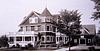
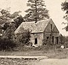
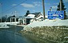
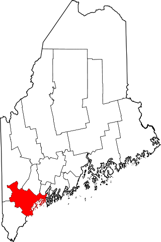
This is a list of the National Register of Historic Places listings in Cumberland County, Maine.

<span class="mw-page-title-main">National Register of Historic Places listings in Athens County, Ohio</span>

This is a list of the National Register of Historic Places listings in Athens County, Ohio.

<span class="mw-page-title-main">National Register of Historic Places listings in Albemarle County, Virginia</span>

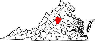
This is a list of the National Register of Historic Places listings in Albemarle County, Virginia.

<span class="mw-page-title-main">National Register of Historic Places listings in Frederick County, Virginia</span>

This is a list of the National Register of Historic Places listings in Frederick County, Virginia.

<span class="mw-page-title-main">National Register of Historic Places listings in York County, Virginia</span>

This is a list of the National Register of Historic Places listings in York County, Virginia.

<span class="mw-page-title-main">National Register of Historic Places listings in Waldo County, Maine</span>

This is a list of the National Register of Historic Places listings in Waldo County, Maine.

<span class="mw-page-title-main">National Register of Historic Places listings in Kennebec County, Maine</span>

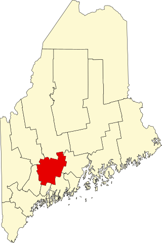
This is a list of the National Register of Historic Places listings in Kennebec County, Maine.

<span class="mw-page-title-main">National Register of Historic Places listings in Androscoggin County, Maine</span>

This is a list of the National Register of Historic Places listings in Androscoggin County, Maine.

<span class="mw-page-title-main">National Register of Historic Places listings in Franklin County, Maine</span>

This is a list of the National Register of Historic Places listings in Franklin County, Maine.

<span class="mw-page-title-main">National Register of Historic Places listings in Sagadahoc County, Maine</span>

This is a list of the National Register of Historic Places listings in Sagadahoc County, Maine.

<span class="mw-page-title-main">National Register of Historic Places listings in Hancock County, Maine</span>

This is a list of the National Register of Historic Places listings in Hancock County, Maine.

<span class="mw-page-title-main">National Register of Historic Places listings in York County, Maine</span>

This is a list of the National Register of Historic Places listings in York County, Maine.

<span class="mw-page-title-main">National Register of Historic Places listings in Oxford County, Maine</span>

This is a list of the National Register of Historic Places listings in Oxford County, Maine.

<span class="mw-page-title-main">National Register of Historic Places listings in Somerset County, Maine</span>

This is a list of the National Register of Historic Places listings in Somerset County, Maine.

<span class="mw-page-title-main">National Register of Historic Places listings in Knox County, Maine</span>

This is a list of the National Register of Historic Places listings in Knox County, Maine.

<span class="mw-page-title-main">National Register of Historic Places listings in Lincoln County, Maine</span>

This is a list of the National Register of Historic Places listings in Lincoln County, Maine.

<span class="mw-page-title-main">National Register of Historic Places listings in Penobscot County, Maine</span>

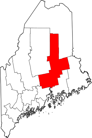
This is a list of properties on the National Register of Historic Places in Penobscot County, Maine.

<span class="mw-page-title-main">National Register of Historic Places listings in Portland, Maine</span>

This is a list of the National Register of Historic Places listings in Portland, Maine.

<span class="mw-page-title-main">National Register of Historic Places listings in Springfield, Massachusetts</span>

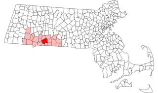
This is a list of the National Register of Historic Places listings in Springfield, Massachusetts.

References

  1. The latitude and longitude information provided in this table was derived originally from the National Register Information System, which has been found to be fairly accurate for about 99% of listings. Some locations in this table may have been corrected to current GPS standards.
  2. National Park Service, United States Department of the Interior, "National Register of Historic Places: Weekly List Actions", retrieved March 17, 2023.
  3. 1 2 Numbers represent an alphabetical ordering by significant words. Various colorings, defined here, differentiate National Historic Landmarks and historic districts from other NRHP buildings, structures, sites or objects.
  4. "National Register Information System". National Register of Historic Places . National Park Service. April 24, 2008.
  5. The eight-digit number below each date is the number assigned to each location in the National Register Information System database, which can be viewed by clicking the number.
  6. "Historic Corriveau Mill in Frenchville torn down". The Bangor Daily News . August 5, 2005. p. B3. Retrieved July 5, 2022 via Newspapers.com.
  7. "Removal of Corriveau Mill" (PDF). National Park Service. Retrieved 2014-12-10.
  8. "Removal of Elmbrook Farm Barn" (PDF). National Park Service. Retrieved 2014-12-10.
  9. "Removal of Smith Bridge" (PDF). National Park Service. Retrieved 2014-12-10.
  10. "Removal of Violette House" (PDF). National Park Service. Retrieved 2014-12-10.
  11. "Historic bridge in Aroostook County destroyed by fire". 20 July 2021.