
Maine is a state in the New England region of the United States, and the northeastern most state in the Lower 48. It borders New Hampshire to the west, the Gulf of Maine to the southeast, and the Canadian provinces of New Brunswick and Quebec to the northeast and northwest, and shares a maritime border with Nova Scotia. Maine is the largest state in New England by total area, nearly larger than the combined area of the remaining five states. Of the 50 U.S. states, it is the 12th-smallest by area, the 9th-least populous, the 13th-least densely populated, and the most rural. Maine's capital is Augusta, and its most populous city is Portland, with a total population of 68,408, as of the 2020 census.
The Green Party of the United States (GPUS) is a federation of Green state political parties in the United States. The party promotes green politics, specifically environmentalism; nonviolence; social justice; participatory democracy; grassroots democracy; anti-war; anti-racism. As of 2023, it is the fourth-largest political party in the United States by voter registration, behind the Libertarian Party.

Frederick Ferdinand Low was an American politician and diplomat who served as the 9th Governor of California from 1863 to 1867. He was previously a member of the United States House of Representatives from 1862 to 1863, and later in life was appointed United States Minister to China, where he served from 1869 to 1873.

1914 United States House of Representatives elections were elections for the United States House of Representatives to elect members to serve in the 64th United States Congress. They were held for the most part on November 3, 1914, while Maine held theirs on September 14. They were held in the middle of President Woodrow Wilson's first term.
The following is a set–index article, providing a list of lists, for the cities, towns and villages within the jurisdictional United States. It is divided, alphabetically, according to the state, territory, or district name in which they are located.

The 1999 NCAA Division I men's ice hockey tournament involved 12 schools in playing in single-elimination play to determine the national champion of NCAA Division I. It began on March 26, 1999. The second round was on March 27 and March 28. The semifinals were on April 1. The National Championship Game was on April 3, 1999. A total of 11 games were played, the final 3 at the Arrowhead Pond in Anaheim, CA. The University of Maine defeated New Hampshire by a score of 3–2 in overtime, to claim their second national championship.
Reading law was the primary method used in common law countries, particularly the United States, for people to prepare for and enter the legal profession before the advent of law schools. It consisted of an extended internship or apprenticeship under the tutelage or mentoring of an experienced lawyer. The practice largely died out in the early 20th century. A few U.S. states, namely California, Maine, New York, Vermont, Virginia and Washington, still permit people to become lawyers by reading law instead of attending some or all of law school, although the practice is rare.

The 1996 United States Senate election in Maine was held November 5, 1996. Incumbent Republican U.S. Senator William Cohen decided to retire instead of seeking a fourth term. To replace him, U.S. Representative Joseph E. Brennan won the Democratic primary while political consultant Susan Collins won the Republican primary. A competitive general election ensued, but Collins ultimately won out over Brennan, keeping the seat in the Republican column. With Collins' election to the Senate in 1996, Maine became the third state after California and Kansas to have two sitting female senators, and the first to have two elected female Republican senators.
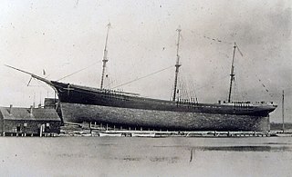
The Down Easter or Downeaster was a type of 19th-century sailing ship built in Maine, and used largely in the California grain trade. It was a modification of the clipper ship using a similar bow but with better cargo handling. It achieved a balance between speed and tonnage such that it made the wheat trade between California and Great Britain competitive with East Coast grain trade via steamship. It could make the trip between San Francisco and Liverpool in 100 days, despite rounding Cape Horn and crossing the equator twice. A more unusual name for the rig was shipentine.

The 1984 United States presidential election in Maine took place on November 6, 1984. All fifty states and the District of Columbia, were part of the 1984 United States presidential election. Voters chose four electors to the Electoral College, which selected the president and vice president of the United States. Maine was won by incumbent United States President Ronald Reagan of California, who was running against former Vice President Walter Mondale of Minnesota. Reagan ran for a second time with former C.I.A. Director George H. W. Bush of Texas, and Mondale ran with Representative Geraldine Ferraro of New York, the first major female candidate for the vice presidency.

The 1980 United States presidential election in Maine took place on November 4, 1980. All fifty states and The District of Columbia were part of the 1980 United States presidential election. Voters chose four electors to the Electoral College, who voted for president and vice president. Maine was won by former California Governor Ronald Reagan (R) by a slim margin of 3%, carrying fourteen out of sixteen counties. In recent years, however, the state has grown much more liberal, and no Republican presidential nominee has carried it since 1988.

The 1968 United States presidential election in Maine took place on November 5, 1968, as part of the 1968 United States presidential election, which was held throughout all fifty states and D.C. Voters chose four representatives, or electors to the Electoral College, who voted for president and vice president.

The 1912 United States presidential election in Maine took place on November 5, 1912, as part of the 1912 United States presidential election which was held throughout all contemporary 48 states. Voters chose six representatives, or electors to the Electoral College, who voted for president and vice president. Maine was won by the Democratic nominees, New Jersey Governor Woodrow Wilson and Indiana Governor Thomas R. Marshall. Wilson and Marshall defeated incumbent President William Howard Taft, and his running mate Vice President James S. Sherman and Progressive Party candidates, former President Theodore Roosevelt and his running mate California Governor Hiram Johnson.

The 1928 United States presidential election in Maine took place on November 6, 1928, as part of the 1928 United States presidential election which was held throughout all contemporary forty-eight states. Voters chose six representatives, or electors to the Electoral College, who voted for president and vice president.
The 1932 United States presidential election in Maine took place on November 8, 1932, as part of the 1932 United States presidential election which was held throughout all contemporary 48 states. Voters chose five representatives, or electors to the Electoral College, who voted for president and vice president.

The 1952 United States presidential election in Maine took place on November 4, 1952, as part of the 1952 United States presidential election which was held throughout all contemporary 48 states. Voters chose five representatives, or electors to the Electoral College, who voted for president and vice president.

The 1956 United States presidential election in Maine took place on November 6, 1956, as part of the 1956 United States presidential election which was held throughout all contemporary 48 states. Voters chose five representatives, or electors to the Electoral College, who voted for president and vice president.

The 1960 United States presidential election in Maine took place on November 8, 1960, as part of the 1960 United States presidential election, which was held throughout all 50 states. Voters chose five representatives, or electors to the Electoral College, who voted for president and vice president.


