
Aroostook County is a county in the U.S. state of Maine along the Canada–U.S. border. As of the 2020 census, the population was 67,105. Its county seat is Houlton, with offices in Caribou and Fort Kent.
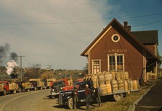
Caribou is the second largest city in Aroostook County, Maine, United States. Its population was 7,396 at the 2020 census, and between the 2010 and 2020 census it was the fastest-shrinking city in Maine. The city is a service center for the agricultural and tourism industries, and the location of a National Weather Service Forecast Office.

Easton is a town in Aroostook County, Maine, United States. The population was 1,320 at the 2020 census.

Presque Isle is the commercial center and largest city in Aroostook County, Maine, United States. The population was 8,797 at the 2020 Census. The city is home to the University of Maine at Presque Isle, Northern Maine Community College, Husson University Presque Isle, Northern Maine Fairgrounds, The Aroostook Centre Mall, and the Presque Isle International Airport.
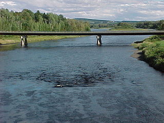
The Aroostook River is a 112-mile-long (180 km) tributary of the Saint John River in the U.S. state of Maine and the Canadian province of New Brunswick. Its basin is the largest sub-drainage of the Saint John River.

The University of Maine at Presque Isle is a public college in Presque Isle, Maine. It is part of the University of Maine System and one of two University of Maine System schools in Aroostook County.

Arthur Robinson Gould was a United States senator from Maine.
Coburn Mountain is a mountain located in Somerset County, Maine.

State Route 164 (SR 164) is part of Maine's system of numbered state highways. It runs 23.6 miles (38.0 km) from Presque Isle to Caribou. It begins at an intersection with U.S. Route 1 (US 1) just north of downtown Presque Isle and travels northwest along the Aroostook River to Crouseville and Washburn. In Washburn, it intersects SR 228. From there, it heads northeast to downtown Caribou. In Caribou, it splits into a one-way pair and also forms a concurrency with SR 161B. The southbound direction of travel through Caribou intersects SR 89 at its western terminus. After traveling through the center of the city, the road heads south along Main Street to end at US 1 south of the city center.

State Route 210 (SR 210) was a state highway entirely in Presque Isle, Maine. It ran in a 6.1-mile (9.8 km) loop from the intersection of U.S. Route 1 (US 1) and SR 164 along the north and west side of the Aroostook River before turning to the west and ending at US 1. The route was originally designated in 1925, and ran between Fryeburg and North Waterford. During the renumbering, it became part of SR 5. Between 1937 and 1938, the number was applied to the loop built as a service road for the Northern Maine Sanitarium. Even after the closure of the sanitarium in the 1970s, the road along which the state route ran remains open and in use.
The East Branch Mattawamkeag River is a tributary of the Mattawamkeag River in Aroostook County, Maine. From its source in Dudley, the river runs 36 miles (58 km) south and southeast to its confluence with the West Branch Mattawamkeag River in Haynesville, about 10 miles (16 km) west of the Canada–United States border.

Alexander Reginald Willette is an American politician from Maine. In 2010, the Republican Willette was elected to represent District 7 in the Maine House of Representatives, covering much of central Aroostook County including part of the city of Presque Isle. He served as the Assistant Republican Leader, and, during his time in the Legislature, was both the youngest member of legislative leadership in Maine's history and the youngest in the United States.
The Benjamin C. Wilder House is an historic house at 1267 Main Street in Washburn, Maine, United States. Built about 1852, it is a well-preserved example of mid-19th century vernacular architecture in northern Aroostook County, built in the first decade after widespread settlement began of the area. The house was listed on the National Register of Historic Places in 1987. It is now owned by the local Salmon Brook Historical Society and operated as a historic house museum.

The Mi'kmaq Nation is a federally recognized tribe of Mi'kmaq people, based in Aroostook County, Maine. Their autonym is Ulustuk. Of the 28 bands of Mi'kmaq people, the Mi'kmaq Nation is the only one in the United States. The Mi'kmaq Nation were the first non-US power to sign a treaty with the United States, the Treaty of Watertown, on 6 July 1776.
Aroostook State Park is public recreation area within the southern municipal boundary of the city of Presque Isle in Aroostook County, Maine. The state park's 898 acres (363 ha) encompass Quaggy Jo Mountain and sit adjacent to Echo Lake. "Quaggy Jo" is an altered version of the mountain's Native American name, "Qua Qua Jo", which means "twin-peaked."
Fairmount Cemetery is an historic cemetery in Presque Isle, Aroostook County, Maine. It is the largest cemetery in northern Maine, with over 30 acres of dedicated land. It overlooks the University of Maine at Presque Isle campus in the south of the city. More than 6,000 people are interred in the cemetery, including over 700 veterans. The cemetery was established in 1864 as a burial place for area Civil War veterans and is managed by the Fairmount Cemetery Association.
The Fish River chain of lakes is a series of five lakes in the North Maine Woods region of northern Maine, in a tributary stream to the Fish River. The lakes are an important northern Maine recreation area providing habitat for wildlife including rainbow smelt, brook trout, lake trout, and land-locked Atlantic salmon.

State Route 163 (SR 163) is a 22.4-mile-long (36.0 km) state highway in the northern part of Maine, United States. It runs between Ashland at SR 11 and Presque Isle at SR 167, entirely in Aroostook County.

State Route 227 (SR 227) is a 24.38-mile-long (39.24 km) state highway located in Aroostook County in northeastern Maine. Its western terminus is at SR 11 in Ashland and its eastern terminus is at SR 163 in Presque Isle after sharing a one-mile-long (1.6 km) concurrency.
Crouse, R. "Crouse Family History" Rogue Publishing, 2000.
Umphrey, Donovan, G. McBurnie, Snell, M. McBurnie, Crouse "Crouseville Pioneer Cemetery" Rogue Publishing, 2006.


