Van Buren (CDP), Maine

Last updated
Van Buren, Maine
Van Buren.JPG
View of Van Buren from Canada
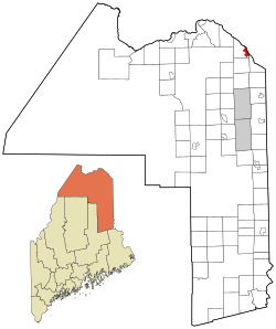
Aroostook County Maine incorporated and unincorporated areas Van Buren (CDP) highlighted.svg
Location of Van Buren, Maine
Coordinates: 47°9′54″N67°56′28″W / 47.16500°N 67.94111°W / 47.16500; -67.94111 Coordinates: 47°9′54″N67°56′28″W / 47.16500°N 67.94111°W / 47.16500; -67.94111
Country United States
State Maine
County Aroostook
Town Van Buren
Area
[1]
  Total4.65 sq mi (12.04 km2)
  Land4.32 sq mi (11.20 km2)
  Water0.33 sq mi (0.84 km2)
Elevation
482 ft (147 m)
Population
 (2020)
  Total1,809
  Density418.46/sq mi (161.57/km2)
Time zone UTC-5 (Eastern (EST))
  Summer (DST) UTC-4 (EDT)
ZIP code
04785
Area code 207
FIPS code 23-78535
GNIS feature ID0577687

Van Buren is a census-designated place (CDP) comprising the main village within the town of Van Buren in Aroostook County, Maine, United States. The population of the CDP was 1,937 at the 2010 census, [2] out of a population of 2,171 for the entire town.

Contents

Geography

The Van Buren CDP is located at 47°9′53″N67°56′27″W / 47.16472°N 67.94083°W / 47.16472; -67.94083 (47.164914, -67.941008) [3] in the southeastern part of the town of Van Buren. The Saint John River forms the northeast border of the CDP and the town and is also the Canada–United States border. U.S. Route 1 passes through the center of the CDP, leading northwest 24 miles (39 km) to Madawaska and 23 miles (37 km) south to Caribou. U.S. Route 1A meets Route 1 near the southeast edge of the CDP and leads south along the Canada–US border 21 miles (34 km) to Limestone. A bridge across the Saint John River at Van Buren leads to Saint-Léonard, New Brunswick, in Canada.

According to the United States Census Bureau, the Van Buren CDP has a total area of 4.4 square miles (11.5 km2), of which 4.2 square miles (10.8 km2) is land and 0.27 square miles (0.7 km2), or 5.87%, is water. [2]

Demographics

Historical population
CensusPop.Note
2020 1,809
U.S. Decennial Census [4]
Languages (2000) [5] Percent
Spoke French at home78.86%
Spoke English at home21.14%

As of the census [6] of 2000, there were 2,369 people, 1,005 households, and 627 families residing in the CDP. The population density was 565.8 inhabitants per square mile (218.5/km2). There were 1,119 housing units at an average density of 267.2 per square mile (103.2/km2). The racial makeup of the CDP was 98.78% White, 0.13% Black or African American, 0.21% Native American, 0.17% Asian, 0.04% from other races, and 0.68% from two or more races. Hispanic or Latino of any race were 0.55% of the population.

There were 1,005 households, out of which 24.6% had children under the age of 18 living with them, 48.4% were married couples living together, 9.5% had a female householder with no husband present, and 37.6% were non-families. 33.2% of all households were made up of individuals, and 16.1% had someone living alone who was 65 years of age or older. The average household size was 2.16 and the average family size was 2.69.

In the CDP, the population was spread out, with 18.8% under the age of 18, 5.4% from 18 to 24, 24.3% from 25 to 44, 28.1% from 45 to 64, and 23.4% who were 65 years of age or older. The median age was 46 years. For every 100 females, there were 87.0 males. For every 100 females age 18 and over, there were 84.9 males.

The median income for a household in the CDP was $19,441, and the median income for a family was $30,870. Males had a median income of $27,917 versus $19,958 for females. The per capita income for the CDP was $13,225. About 16.1% of families and 23.2% of the population were below the poverty line, including 31.0% of those under age 18 and 12.7% of those age 65 or over.

Related Research Articles

<span class="mw-page-title-main">Henry County, Iowa</span> County in Iowa, United States

Henry County is a county located in the U.S. state of Iowa. As of the 2020 census, the population was 20,482. The county seat is Mount Pleasant. The county was named for General Henry Dodge, governor of Wisconsin Territory.

<span class="mw-page-title-main">Beluga, Alaska</span> Census-designated place in Alaska, United States

Beluga is a census-designated place (CDP) in Kenai Peninsula Borough, Alaska, United States. The population was 20 at the 2010 census, down from 32 in 2000.

<span class="mw-page-title-main">Star City, Indiana</span> Census-designated place in Indiana, United States

Star City is a census-designated place (CDP) in Van Buren Township, Pulaski County, in the U.S. state of Indiana. The population was 344 at the 2010 census.

<span class="mw-page-title-main">Douds, Iowa</span> CDP in Iowa, United States

Douds is a census-designated place (CDP) in Van Buren County, Iowa, United States. The population was 165 at the 2000 census.

<span class="mw-page-title-main">Leando, Iowa</span> CDP in Iowa, United States

Leando is a census-designated place (CDP) in Van Buren County, Iowa, United States. The population was 135 at the 2000 census.

<span class="mw-page-title-main">Stockport, Iowa</span> City in Iowa, United States

Stockport is a city in Van Buren County, Iowa, United States. The population was 272 at the time of the 2020 census.

<span class="mw-page-title-main">Hamlin, Maine</span> Town in the state of Maine, United States

Hamlin is a town in Aroostook County, Maine, United States. It is located on the Canada–US border with a border crossing into Grand Falls, New Brunswick and is the closest continental location to Europe in the United States. Hamlin's northeast corner is the closest point in the mainland United States to Western Europe, situated at a distance of 2,508 miles (4,018 km) from the closest point in Europe to the USA, Achill Head. The population was 166 at the 2020 census.

<span class="mw-page-title-main">Twin Lake, Michigan</span> Census-designated place & unincorporated community in Michigan, United States

Twin Lake is an unincorporated community in Muskegon County of the U.S. state of Michigan. It is a census-designated place (CDP) for statistical purposes. Local government services are provided by Dalton Township. As of the 2000 census, the community population was 1,613. It is the home of Blue Lake Fine Arts Camp, the YMCA's Camp Pinewood, the Boy Scouts' Gerber Scout Reservation and Owasippe Scout Reservation.

<span class="mw-page-title-main">Van Buren, Missouri</span> City in Missouri, United States

Van Buren is a city in Carter County, Missouri, United States. It is the county seat and largest city in Carter County. Van Buren was founded in 1833 as the county seat of Ripley County and was named after then Vice President of the United States, Martin Van Buren. In 1859, Van Buren became a part of the newly created Carter County and was subsequently selected to be the county seat. The 2020 U.S. Census showed Van Buren with a population of 747.

<span class="mw-page-title-main">Rocky Point, Montana</span> Census-designated place in Montana, United States

Rocky Point is a census-designated place (CDP) in Lake County, Montana, United States. The population was 97 at the 2010 census.

<span class="mw-page-title-main">Cedar Grove, New Mexico</span> CDP in New Mexico, United States

Cedar Grove is a census-designated place (CDP) in Santa Fe County, New Mexico, United States. It is part of the Santa Fe, New Mexico Metropolitan Statistical Area. The population was 747 at the 2010 census.

<span class="mw-page-title-main">Van Buren, Ohio</span> Village in Ohio, United States

Van Buren is a village in Hancock County, Ohio, United States. The population was 328 at the 2010 census.

<span class="mw-page-title-main">Horsepasture, Virginia</span> CDP in Virginia, United States

Horsepasture is a census-designated place (CDP) in Henry County, Virginia, United States. The population was 2,227 at the 2010 census. It is part of the Martinsville Micropolitan Statistical Area.

<span class="mw-page-title-main">Ames Lake, Washington</span> Census-designated place in Washington, United States

Ames Lake is an unincorporated community and census-designated place (CDP) in King County, Washington, United States. The population was 1,486 at the 2010 census.

<span class="mw-page-title-main">Centerville, Washington</span> Census-designated place in Washington, United States

Centerville is an unincorporated community and census-designated place (CDP) in Klickitat County, Washington, United States. Settled in 1877 by Albert J. Brown, the population was 112 at the 2010 census.

<span class="mw-page-title-main">Lake Roesiger, Washington</span> CDP in Washington, United States

Lake Roesiger is a census-designated place (CDP) in Snohomish County, Washington, United States. The population was 503 at the 2010 census.

<span class="mw-page-title-main">Deming, Washington</span> CDP in Washington, United States

Deming is a census-designated place (CDP) in Whatcom County, Washington, United States, along the Nooksack River. It is named for its first postmaster, George Deming. The community population was 353 at the 2010 census.

<span class="mw-page-title-main">Chain O' Lakes-King, Wisconsin</span> Former CDP in Wisconsin, United States

Chain O' Lakes-King is a former census-designated place (CDP) in Waupaca County, Wisconsin, United States. The population was 2,215 at the 2000 census. It is located within the towns of Farmington and Dayton. For the 2010 census, Chain O' Lakes-King was split into the CDPs of Chain O' Lakes and King.

<span class="mw-page-title-main">Van Buren, Maine</span> Town in Maine, United States

Van Buren is a town on the Saint John River in Aroostook County, Maine, United States; located across from Saint-Leonard, New Brunswick, Canada. The population was 2,038 at the 2020 census. It is named after U.S. President Martin Van Buren.

Machias is a census-designated place (CDP) corresponding to the central village area within the town of Machias in Washington County, Maine, United States. The population of the CDP was 1,274 at the 2010 census.

References

  1. "2020 U.S. Gazetteer Files". United States Census Bureau. Retrieved April 8, 2022.
  2. 1 2 "Geographic Identifiers: 2010 Demographic Profile Data (G001): Van Buren CDP, Maine". U.S. Census Bureau, American Factfinder. Archived from the original on February 12, 2020. Retrieved May 22, 2013.
  3. "US Gazetteer files: 2010, 2000, and 1990". United States Census Bureau. 2011-02-12. Retrieved 2011-04-23.
  4. "Census of Population and Housing". Census.gov. Retrieved June 4, 2016.
  5. "Data Center Results".
  6. "U.S. Census website". United States Census Bureau . Retrieved 2008-01-31.