Island Falls, Maine

Last updated

Island Falls, Maine
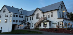
Uniquefrontal.png
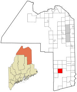
Aroostook County Maine incorporated and unincorporated areas Island Falls highlighted.svg
Location of Island Falls, Maine
Coordinates: 46°0′31″N68°15′53″W / 46.00861°N 68.26472°W / 46.00861; -68.26472
Country United States
State Maine
County Aroostook
Area
[1]
  Total40.76 sq mi (105.57 km2)
  Land36.03 sq mi (93.32 km2)
  Water4.73 sq mi (12.25 km2)
Elevation
443 ft (135 m)
Population
 (2020)
  Total758
  Density21/sq mi (8.1/km2)
Time zone UTC-5 (Eastern (EST))
  Summer (DST) UTC-4 (EDT)
ZIP code
04747
Area code 207
FIPS code 23-35065
GNIS feature ID0582529
Website www.islandfallsme.us

Island Falls is a town in Aroostook County, Maine, United States. The population was 758 at the 2020 census. [2] The primary village of Island Falls in the town is situated at a falls in the West Branch Mattawamkeag River. [3]

Contents

Geography

According to the United States Census Bureau, the town has a total area of 40.76 square miles (105.57 km2), of which 36.03 square miles (93.32 km2) is land and 4.73 square miles (12.25 km2) is water. [1] Island Falls also has two main lakes, Pleasant and Mattawamkeag.

Demographics

Historical population
CensusPop.Note
1870 183
1880 23629.0%
1890 223−5.5%
1900 1,063376.7%
1910 1,68658.6%
1920 1,683−0.2%
1930 1,455−13.5%
1940 1,370−5.8%
1950 1,237−9.7%
1960 1,018−17.7%
1970 913−10.3%
1980 9817.4%
1990 897−8.6%
2000 793−11.6%
2010 8375.5%
2020 758−9.4%
U.S. Decennial Census [4]

2010 census

As of the census [5] of 2010, there were 837 people, 357 households, and 228 families living in the town. The population density was 23.2 inhabitants per square mile (9.0/km2). There were 655 housing units at an average density of 18.2 per square mile (7.0/km2). The racial makeup of the town was 97.4% White, 0.4% African American, 0.8% Native American, 0.1% Asian, 0.2% from other races, and 1.1% from two or more races. Hispanic or Latino of any race were 2.0% of the population.

There were 357 households, of which 25.8% had children under the age of 18 living with them, 49.0% were married couples living together, 11.5% had a female householder with no husband present, 3.4% had a male householder with no wife present, and 36.1% were non-families. 31.9% of all households were made up of individuals, and 19.3% had someone living alone who was 65 years of age or older. The average household size was 2.31 and the average family size was 2.88.

The median age in the town was 46.4 years. 21.5% of residents were under the age of 18; 6.2% were between the ages of 18 and 24; 20.7% were from 25 to 44; 31.5% were from 45 to 64; and 20% were 65 years of age or older. The gender makeup of the town was 49.6% male and 50.4% female.

2000 census

At the 2000 census, [6] there were 793 people, 346 households and 229 families living in the town. The population density was 22.1 per square mile (8.5/km2). There were 635 housing units at an average density of 17.7 per square mile (6.8/km2). The racial makeup of the town was 99.12% White, 0.76% Native American and 0.13% Asian. Hispanic or Latino of any race were 0.88% of the population.

There were 346 households, of which 26.9% had children under the age of 18 living with them, 55.2% were married couples living together, 8.7% had a female householder with no husband present, and 33.8% were non-families. 28.6% of all households were made up of individuals, and 14.2% had someone living alone who was 65 years of age or older. The average household size was 2.29 and the average family size was 2.81.

21.1% of the population was under the age of 18, 8.6% from 18 to 24, 24.1% from 25 to 44, 28.1% from 45 to 64, and 18.2% who were 65 years of age or older. The median age was 43 years. For every 100 females, there were 90.6 males. For every 100 females age 18 and over, there were 92.0 males.

The median household income was $27,083, and the median family income was $35,375. Males had a median income of $32,019 versus $19,028 for females. The per capita income for the town was $15,132. About 10.5% of families and 14.2% of the population were below the poverty line, including 19.1% of those under age 18 and 11.6% of those age 65 or over.

Places of interest

Related Research Articles

<span class="mw-page-title-main">Penobscot County, Maine</span> County in Maine, United States

Penobscot County is a county in the U.S. state of Maine, named for the Penobscot people in Wabanakik. As of the 2020 census, the population was 152,199, making it the third-most-populous county in Maine. Its county seat is Bangor. The county was established on February 15, 1816, from part of Hancock County when the area was still part of Massachusetts. Penobscot County is home to the University of Maine.

Frenchboro is a town in Hancock County, Maine, United States, and a village within this town located on Long Island, southeast of Swans Island. The population was 29 at the 2020 census. The town is accessible by state ferry service from Bass Harbor.

<span class="mw-page-title-main">Lamoine, Maine</span> Town in the state of Maine, United States

Lamoine is a town in Hancock County, Maine, United States. The town was named after an early resident, Andre LeMoyne. The spelling shifted slightly over the years. "Le moine" is French for "the monk." The population was 1,720 at the 2020 census.

<span class="mw-page-title-main">Hebron, Maine</span> Town in the state of Maine, United States

Hebron is a town in Oxford County, Maine, United States. Hebron is included in the Lewiston-Auburn, Maine metropolitan New England city and town area. The town's history has always been interconnected with Hebron Academy, a co-ed college preparatory boarding school which is located in the town's heart. The population was 1,223 at the 2020 census. There is an elementary school, Hebron Station School, located on Station Road.

<span class="mw-page-title-main">Roxbury, Maine</span> Town in the state of Maine, United States

Roxbury is a town in Oxford County, Maine, United States. The population was 361 at the 2020 census. Ellis Pond is popular with recreational fishermen.

Burlington is a town in Penobscot County, Maine, United States. It is part of the Bangor Metropolitan Statistical Area. The population was 373 at the 2020 census.

Garland is a town in Penobscot County, Maine, United States. The population was 1,026 at the 2020 census.

LaGrange is a town in Penobscot County, Maine, United States. The population was 635 at the 2020 census.

<span class="mw-page-title-main">Mattawamkeag, Maine</span> Town in the state of Maine, United States

Mattawamkeag is a town in Penobscot County, Maine, United States, located where the Mattawamkeag River joins the Penobscot River. The population was 596 at the 2020 census. The village of Mattawamkeag is in the southwestern part of the town.

<span class="mw-page-title-main">Mount Chase, Maine</span> Town in the state of Maine, United States

Mount Chase is a town in Penobscot County, Maine, United States. The population was 187 at the 2020 census.

Patten is a small town in Penobscot County, Maine, United States. At the 2020 census, the population was 881. The village of Patten is in the northeastern part of the town.

<span class="mw-page-title-main">Bowerbank, Maine</span> Town in the state of Maine, United States

Bowerbank is a town in Piscataquis County, Maine, United States. The population was 136 at the 2020 census.

<span class="mw-page-title-main">Sebec, Maine</span> Town in the state of Maine, United States

Sebec is a town in Piscataquis County, Maine, United States. The population was 665 at the 2020 census.

<span class="mw-page-title-main">Columbia Falls, Maine</span> Town in the state of Maine, United States

Columbia Falls is a town in Washington County, Maine, United States. The population was 476 at the 2020 census.

<span class="mw-page-title-main">Pembroke, Maine</span> Town in the state of Maine, United States

Pembroke is a town in Washington County, Maine, United States. The population was 788 at the 2020 census. The town is home to a reversing falls on Mahar's Point.

<span class="mw-page-title-main">Little Suamico, Wisconsin</span> Town in Wisconsin, United States

Little Suamico is a town in Oconto County, Wisconsin, United States. The population was 3,877 at the 2000 census.

<span class="mw-page-title-main">Westport Island, Maine</span> Town in the state of Maine, United States

Westport Island, formerly Westport, is a town in Lincoln County, Maine, United States. In the 19th century the island was known as Jeremysquam, a nickname islanders still use for it. The population was 719 at the 2020 census.

<span class="mw-page-title-main">Livermore Falls (CDP), Maine</span> Census-designated place in Maine, United States

Livermore Falls is a census-designated place (CDP) in the town of Livermore Falls in Androscoggin County, Maine, United States. The population of the CDP was 1,594 at the 2010 census, out of a population of 3,187 within the full town.

<span class="mw-page-title-main">Livermore Falls, Maine</span> Town in the state of Maine, United States

Livermore Falls is a town in Androscoggin County, Maine, United States. The population was 3,060 at the 2020 census. It is included in both the Lewiston-Auburn, Maine Metropolitan Statistical Area and the Lewiston-Auburn, Maine Metropolitan New England City and Town Area. High school students in Livermore Falls attend Spruce Mountain High School.

<span class="mw-page-title-main">Mechanic Falls, Maine</span> Town in the state of Maine, United States

Mechanic Falls is a town in Androscoggin County, Maine, United States. The population was 3,107 at the 2020 census. It is included in both the Lewiston-Auburn, Maine metropolitan statistical area and the Lewiston-Auburn, Maine metropolitan New England city and town area.

References

  1. 1 2 "US Gazetteer files 2010". United States Census Bureau. Archived from the original on December 20, 2012. Retrieved December 16, 2012.
  2. "Census - Geography Profile: Island Falls town, Aroostook County, Maine" . Retrieved January 23, 2022.
  3. Gannett, Henry (1905). The Origin of Certain Place Names in the United States. Govt. Print. Off. pp.  166.
  4. "Census of Population and Housing". Census.gov. Retrieved June 4, 2015.
  5. "U.S. Census website". United States Census Bureau . Retrieved December 16, 2012.
  6. "U.S. Census website". United States Census Bureau . Retrieved January 31, 2008.

46°00′33″N68°16′17″W / 46.00917°N 68.27139°W / 46.00917; -68.27139