Fort Kent (CDP), Maine

Last updated

Fort Kent, Maine
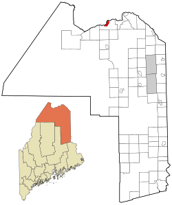
Aroostook County Maine incorporated and unincorporated areas Fort Kent (CDP) highlighted.svg
Location of Fort Kent, Maine
Coordinates: 47°15′18″N68°35′8″W / 47.25500°N 68.58556°W / 47.25500; -68.58556 Coordinates: 47°15′18″N68°35′8″W / 47.25500°N 68.58556°W / 47.25500; -68.58556
CountryUnited States
State Maine
County Aroostook
Town Fort Kent
Area
[1]
  Total5.62 sq mi (14.55 km2)
  Land5.36 sq mi (13.87 km2)
  Water0.26 sq mi (0.68 km2)
Elevation
561 ft (171 m)
Population
 (2020)
  Total2,413
  Density450.61/sq mi (173.97/km2)
Time zone UTC-5 (Eastern (EST))
  Summer (DST) UTC-4 (EDT)
ZIP codes
04741, 04743
Area code 207
FIPS code 23-25720
GNIS feature ID0566413

Fort Kent is a census-designated place (CDP) that comprises the main village in the town of Fort Kent in Aroostook County, Maine, United States. In 2010, Fort Kent's population was 2,488 of 4,097 for the entire town. [2]

Contents

Geography

The Fort Kent CDP is located at 47°15′17″N68°35′7″W / 47.25472°N 68.58528°W / 47.25472; -68.58528 (47.254945, −68.585421), [3] along the Saint John River, which forms the northern border of the town as well as the Canada–United States border. The northern terminus of U.S. Route 1 is near the center of the CDP, at the bridge across the Saint John River into Clair, New Brunswick. Maine State Route 161 and Maine State Route 11 intersect Route 1 within the CDP.

According to the United States Census Bureau, the CDP has a total area of 5.6 square miles (14.5 km2), of which 5.4 square miles (13.9 km2) is land and 0.23 square miles (0.6 km2), or 4.01%, is water. [2] The CDP is located at the confluence of the Fish River with the Saint John River.

Demographics

Historical population
CensusPop.Note
2020 2,413
U.S. Decennial Census [4]
Languages (2000) [5] Percent
Spoke French at home60.66%
Spoke English at home39.34%

As of the census [6] of 2000, there were 1,979 people, 894 households, and 455 families residing in the CDP. The population density was 610.8 inhabitants per square mile (235.8/km2). There were 940 housing units at an average density of 290.3 per square mile (112.1/km2). The racial makeup of the CDP was 97.07% White, 0.51% Black or African American, 0.61% Native American, 0.96% Asian, 0.10% from other races, and 0.76% from two or more races. Hispanic or Latino of any race were 0.61% of the population.

There were 894 households, out of which 19.8% had children under the age of 18 living with them, 42.8% were married couples living together, 5.8% had a female householder with no husband present, and 49.1% were non-families. 40.6% of all households were made up of individuals, and 20.4% had someone living alone who was 65 years of age or older. The average household size was 2.03 and the average family size was 2.76.

In the CDP, the population was spread out, with 16.8% under the age of 18, 15.6% from 18 to 24, 23.4% from 25 to 44, 21.8% from 45 to 64, and 22.4% who were 65 years of age or older. The median age was 41 years. For every 100 females, there were 88.2 males. For every 100 females age 18 and over, there were 86.5 males.

The median income for a household in the CDP was $20,914, and the median income for a family was $36,250. Males had a median income of $38,333 versus $18,092 for females. The per capita income for the CDP was $13,882. About 12.8% of families and 22.7% of the population were below the poverty line, including 25.0% of those under age 18 and 20.2% of those age 65 or over.

Related Research Articles

<span class="mw-page-title-main">Brushy, Oklahoma</span> CDP in Oklahoma, United States

Brushy is a census-designated place (CDP) in Sequoyah County, Oklahoma, United States, along U.S. Route 59 in the foothills of the Brushy Mountains. It is part of the Fort Smith, Arkansas-Oklahoma Metropolitan Statistical Area. The population was 900 at the 2010 census, an increase of 14.4 percent over the figure of 787 recorded in 2000.

<span class="mw-page-title-main">Orchard Hills, Pennsylvania</span> Census-designated place in Pennsylvania, United States

Orchard Hills is a census-designated place (CDP) in Armstrong County, Pennsylvania, United States. The population was 1,952 at the 2010 census.

Milroy is a census-designated place (CDP) that is located in the Kishacoquillas Valley of Mifflin County, Pennsylvania, United States. The population was 1,386 at the time of the 2000 census.

<span class="mw-page-title-main">Van Buren (CDP), Maine</span> Census-designated place in Maine, United States

Van Buren is a census-designated place (CDP) comprising the main village within the town of Van Buren in Aroostook County, Maine, United States. The population of the CDP was 1,937 at the 2010 census, out of a population of 2,171 for the entire town.

Gorham is a census-designated place (CDP) and the main village in the town of Gorham in Coos County, New Hampshire, United States. The population of the CDP was 1,851 at the 2020 census, out of 2,698 people in the entire town of Gorham.

<span class="mw-page-title-main">Fort Fairfield (CDP), Maine</span> Census-designated place in Maine, United States

Fort Fairfield is a census-designated place (CDP) comprising the main village within the town of Fort Fairfield in Aroostook County, Maine, United States. The population of the CDP was 1,825 at the 2010 census, out of a population of 3,496 for the entire town.

<span class="mw-page-title-main">Madawaska (CDP), Maine</span> Census-designated place in Maine, United States

Madawaska is a census-designated place (CDP) comprising the main village within the town of Madawaska in Aroostook County, Maine, United States. The population of the CDP was 2,967 at the 2010 census, out of a population of 4,035 for the entire town.

<span class="mw-page-title-main">Farmington (CDP), Maine</span> Census-designated place in Maine, United States

Farmington is a census-designated place (CDP) comprising the center of the town of Farmington, which is the county seat of Franklin County in Maine, United States. The population of the CDP was 4,288 at the 2010 census, out of 7,760 people in the town as a whole. The University of Maine at Farmington is located within the CDP.

Bar Harbor is a census-designated place (CDP) in the town of Bar Harbor in Hancock County, Maine, United States. The CDP population was 2,552 at the 2010 census, out of a population of 5,235 in the town of Bar Harbor as a whole.

Bucksport is a census-designated place (CDP) in the town of Bucksport in Hancock County, Maine, United States. The population was 2,885 at the 2010 census, down from 2,970 at the 2000 census.

<span class="mw-page-title-main">Oakland (CDP), Maine</span> Census-designated place in Maine, United States

Oakland is a census-designated place (CDP) comprising the main population center in the town of Oakland in Kennebec County, Maine, United States. The population was 2,602 at the 2010 census, out of 6,240 in the entire town of Oakland.

<span class="mw-page-title-main">Winthrop (CDP), Maine</span> Census-designated place in Maine, United States

Winthrop is a census-designated place (CDP) comprising the primary settlement in the town of Winthrop in Kennebec County, Maine, United States. The population was 2,650 at the 2010 census, out of 6,092 in the town of Winthrop as a whole.

<span class="mw-page-title-main">Camden (CDP), Maine</span> Census-designated place in Maine, United States

Camden is a census-designated place (CDP) comprising the main village in the town of Camden in Knox County, Maine, United States. The population was 3,570 at the 2010 census, out of 4,850 in the entire town of Camden.

<span class="mw-page-title-main">Boothbay Harbor (CDP), Maine</span> Census-designated place in Maine, United States

Boothbay Harbor is a census-designated place (CDP) comprising the densely populated center of the town of Boothbay Harbor in Lincoln County, Maine, United States. The population was 1,086 at the 2010 census, down from 1,237 at the 2000 census.

<span class="mw-page-title-main">Waldoboro (CDP), Maine</span> Census-designated place in Maine, United States

Waldoboro is a census-designated place (CDP) comprising the central village in the town of Waldoboro in Lincoln County, Maine, United States. The population was 1,233 at the 2010 census, out of 5,075 people in the entire town of Waldoboro.

<span class="mw-page-title-main">Wiscasset (CDP), Maine</span> Census-designated place in Maine, United States

Wiscasset is a census-designated place (CDP) comprising the primary settlement in the town of Wiscasset in Lincoln County, Maine, United States. The population was 1,097 at the 2010 census, out of 3,732 people in the entire town. Wiscasset is the county seat of Lincoln County.

East Millinocket is a census-designated place (CDP) consisting of the main settlement in the town of East Millinocket in Penobscot County, Maine, United States. The population was 1,567 at the 2010 census.

Millinocket is a census-designated place (CDP) comprising most of the developed land within the town of Millinocket in Penobscot County, Maine, United States. The population of the CDP was 4,466 at the 2010 census.

Orono is a census-designated place (CDP) consisting of the eastern portion of the town of Orono in Penobscot County, Maine, United States. The population of the CDP was 9,474 at the 2010 census.

<span class="mw-page-title-main">Milo (CDP), Maine</span> CDP in Maine, United States

Milo is a census-designated place (CDP) in the town of Milo in Piscataquis County, Maine, United States. The population was 1,898 at the 2000 census.

References

  1. "2020 U.S. Gazetteer Files". United States Census Bureau. Retrieved April 8, 2022.
  2. 1 2 "Geographic Identifiers: 2010 Demographic Profile Data (G001): Fort Kent CDP, Maine". U.S. Census Bureau, American Factfinder. Archived from the original on February 12, 2020. Retrieved May 22, 2013.
  3. "US Gazetteer files: 2010, 2000, and 1990". United States Census Bureau. February 12, 2011. Retrieved April 23, 2011.
  4. "Census of Population and Housing". Census.gov. Retrieved June 4, 2016.
  5. "Data Center Results".
  6. "U.S. Census website". United States Census Bureau . Retrieved January 31, 2008.