Oxbow, Maine

Last updated
Oxbow North, Maine
Township
Nickname: 
Oxbow
Aroostook County Maine incorporated and unincorporated areas Oxbow highlighted.svg
Location of Oxbow, Maine
Coordinates: 46°25′23″N68°30′41″W / 46.42306°N 68.51139°W / 46.42306; -68.51139
Country United States
State Maine
County Aroostook
Area
  Total38.3 sq mi (99.1 km2)
  Land37.8 sq mi (97.9 km2)
  Water0.5 sq mi (1.2 km2)
Elevation
679 ft (207 m)
Population
 (2010)
  Total66
  Density1.7/sq mi (0.67/km2)
Time zone UTC-5 (Eastern (EST))
  Summer (DST) UTC-4 (EDT)
ZIP code
04764
Area code 207
FIPS code 23-56205
GNIS feature ID0582657

Oxbow, officially Oxbow North and Township 9 Range 6, is an unincorporated township in Aroostook County, Maine, United States and part of the state's Unorganized Territory. The population was 66 at the 2010 census. [1] As of 2016, the population was estimated to be 50. [2]

Contents

History

Oxbow was first settled in 1842 by Elias and Samuel Hayden, who had previously resided in Somerset County, Maine. More settlers came to set up farms and mills, which spurred residents to incorporate as Oxbow Plantation in 1870. In 1994, an attempt to deorganize was defeated by a vote of 21–9. [3] In November 2015, Oxbow residents voted unanimously to deorganize, which was largely driven by a need to lower property tax rates. [3] In March 2016, a panel of the Maine Legislature voted to accept the town's attempt to deorganize. [4] In November 2016, town residents voted 37–2 to move forward with the process. The plantation was officially deorganized on July 1, 2017. [2]

Geography

According to the United States Census Bureau, the township has a total area of 38.3 square miles (99.1 km2), of which 37.8 square miles (97.9 km2) is land and 0.46 square miles (1.2 km2), or 1.22%, is water. [1]

Demographics

Historical population
CensusPop.Note
1870 100
1880 12727.0%
1890 94−26.0%
1900 15362.8%
1910 18118.3%
1920 1989.4%
1930 176−11.1%
1940 1781.1%
1950 1896.2%
1960 137−27.5%
1970 92−32.8%
1980 84−8.7%
1990 69−17.9%
2000 56−18.8%
2010 6617.9%
2016 (est.)50 [5] −24.2%
U.S. Decennial Census [6]

As of the census [7] of 2000, there were 56 people, 29 households, and 20 families residing in the township. The population density was 1.5 inhabitants per square mile (0.58/km2). There were 83 housing units at an average density of 2.2 per square mile (0.85/km2). The racial makeup of the township was 100.00% White. Hispanic or Latino of any race were 1.79% of the population.

There were 29 households, out of which 13.8% had children under the age of 18 living with them, 62.1% were married couples living together, 6.9% had a female householder with no husband present, and 31.0% were non-families. 24.1% of all households were made up of individuals, and 20.7% had someone living alone who was 65 years of age or older. The average household size was 1.93 and the average family size was 2.20.

In the township, the population was spread out, with 8.9% under the age of 18, 5.4% from 18 to 24, 17.9% from 25 to 44, 35.7% from 45 to 64, and 32.1% who were 65 years of age or older. The median age was 52 years. For every 100 females there were 107.4 males. For every 100 females age 18 and over, there were 96.2 males.

The median income for a household in the township was $33,333, and the median income for a family was $35,000. Males had a median income of $37,917 versus $28,750 for females. The per capita income for the township was $15,247. There were 18.2% of families and 21.6% of the population living below the poverty line, including 50.0% of under eighteens and none of those over 64.

Related Research Articles

<span class="mw-page-title-main">Aroostook County, Maine</span> County in Maine, United States

Aroostook County is a county in the U.S. state of Maine along the Canada–United States border. As of the 2020 census, the population was 67,105. Its county seat is Houlton, with offices in Caribou and Fort Kent.

<span class="mw-page-title-main">Ashland, Maine</span> Town in Maine, United States

Ashland is a town in Aroostook County, Maine, United States. The population was 1,202 at the 2020 census.

<span class="mw-page-title-main">Bancroft, Maine</span> Unorganized territory in Maine, United States

Bancroft is a township in Aroostook County, Maine, United States. The population was 57 at the 2020 census. On July 1, 2015 the town voted to deorganize and become part of the unorganized territory of South Aroostook.

<span class="mw-page-title-main">Cary, Maine</span> Township in Maine, United States

Cary is an unorganized township and former plantation in Aroostook County, Maine, United States, and is part of the unorganized territory of South Aroostook, Maine. As of the 2010 census, it had a population of 218.

<span class="mw-page-title-main">Castle Hill, Maine</span> Town in the state of Maine, United States

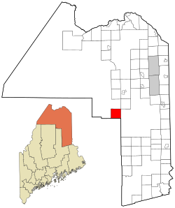
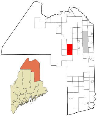
Castle Hill is a town in Aroostook County, Maine, United States. The population was 373 people at the 2020 census.

<span class="mw-page-title-main">Cyr Plantation, Maine</span> Plantation in Maine, United States

Cyr Plantation is a plantation in Aroostook County, Maine, United States. The population was 78 at the 2020 census.

<span class="mw-page-title-main">Easton, Maine</span> Town in the state of Maine, United States

Easton is a town in Aroostook County, Maine, United States. The population was 1,320 at the 2020 census.

<span class="mw-page-title-main">Garfield Plantation, Maine</span> Plantation in Maine, United States

Garfield Plantation is a plantation in Aroostook County, Maine, United States. The population was 79 at the 2020 census.

<span class="mw-page-title-main">Macwahoc Plantation, Maine</span> Plantation in Maine, United States

Macwahoc Plantation is a plantation in Aroostook County, Maine, United States. The population was 62 at the 2020 census.

<span class="mw-page-title-main">Moro Plantation, Maine</span> Plantation in Maine, United States

Moro Plantation is a plantation in Aroostook County, Maine, United States. The population was 44 at the 2020 census.

<span class="mw-page-title-main">Nashville Plantation, Maine</span> Plantation in Maine, United States

Nashville Plantation is a plantation in Aroostook County, Maine, United States. The population was 27 at the 2020 census.

<span class="mw-page-title-main">New Limerick, Maine</span> Town in the state of Maine, United States

New Limerick is a town in Aroostook County, Maine, United States. The population was 574 at the 2020 census. The town was settled in 1775 and incorporated on March 18, 1837 from New Limerick Plantation. It received its name from the fact that many of its settlers had previously lived in Limerick in York County at the southern end of the state, which in turn was probably named after the Irish city of Limerick.

<span class="mw-page-title-main">Saint John Plantation, Maine</span> Plantation in Maine, United States

Saint John Plantation is a plantation in Aroostook County, Maine, United States, on the banks of the Saint John River. The population was 263 at the 2020 census.

<span class="mw-page-title-main">Stockholm, Maine</span> Town in the state of Maine, United States

Stockholm is a town in Aroostook County, Maine, United States. The population was 250 at the 2020 census.

<span class="mw-page-title-main">Westmanland, Maine</span> Town in the state of Maine, United States

Westmanland is a town in Aroostook County, Maine, United States. The population was 79 at the 2020 census.

<span class="mw-page-title-main">Magalloway, Maine</span> Township in Maine, United States

Magalloway is a township in Oxford County, Maine, United States. It has been part of North Oxford unorganized territory since it de-organized as a plantation in 2021. The population was 45 at the 2020 census. Part of the Umbagog National Wildlife Refuge is located at its southwestern corner.

Drew is a township in Penobscot County, Maine, United States. The population was 26 at the 2020 census. It is part of the Bangor Metropolitan Statistical Area. The Surety of Sinners Orthodox Mission, a Russian Orthodox church, is located in Drew. A former plantation, Drew completed the de-organization process in 2023 to become part of Maine's unorganized territory.

<span class="mw-page-title-main">Atkinson, Maine</span> Township in Maine, United States

Atkinson is an unincorporated township and former town in Piscataquis County, Maine, United States, and part of the unorganized territory of Southeast Piscataquis, Maine. Its population was 326 at the 2010 census.

<span class="mw-page-title-main">Northwest Aroostook, Maine</span> Unorganized territory in Maine, United States

Northwest Aroostook is an unorganized territory in Aroostook County, Maine, United States. The population was 12 at the 2020 census.

<span class="mw-page-title-main">South Aroostook, Maine</span> Unorganized territory in Maine, United States

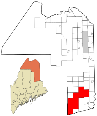
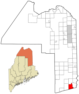
South Aroostook is an unorganized territory in Aroostook County, Maine, United States. The population was 579 at the 2020 census.

References

  1. 1 2 "Geographic Identifiers: 2010 Demographic Profile Data (G001): Oxbow plantation, Aroostook County, Maine". U.S. Census Bureau, American Factfinder. Archived from the original on February 12, 2020. Retrieved May 21, 2013.
  2. 1 2 Brino, Anthony (November 9, 2016). "Oxbow deorganization goes forward". Bangor Daily News . Retrieved 10 November 2016.
  3. 1 2 Brino, Anthony (November 27, 2015). "Oxbow Plantation residents vote to deorganize". Bangor Daily News . Retrieved 28 November 2015.
  4. Higgins, AJ. "Officials Fear Domino Effect as Aroostook County Towns Try to Deorganize". Maine Public Broadcasting Network . Retrieved 13 March 2016.
  5. "Annual Estimates of the Resident Population for Incorporated Places: April 1, 2010 to July 1, 2014". Archived from the original on May 23, 2015. Retrieved June 4, 2015.
  6. "Census of Population and Housing". Census.gov. Retrieved June 4, 2015.
  7. "U.S. Census website". United States Census Bureau . Retrieved 2008-01-31.

46°25′07″N68°29′24″W / 46.41861°N 68.49000°W / 46.41861; -68.49000