Aroostook County is a county in the U.S. state of Maine along the Canada–U.S. border. As of the 2020 census, the population was 67,105. Its county seat is Houlton, with offices in Caribou and Fort Kent.
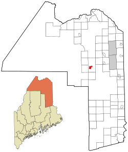
Ashland is a town in Aroostook County, Maine, United States. The population was 1,202 at the 2020 census.

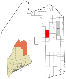
Frenchville is a town in Aroostook County, Maine, United States. The population was 1,052 at the 2020 census.

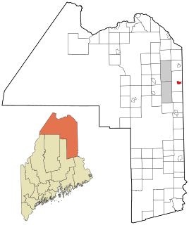
Grand Isle is a town in Aroostook County, Maine, United States. The population was 366 at the 2020 census. The village of Grand Isle is in the northwest part of the town.

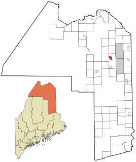
St. Francis is a town in Aroostook County, Maine, United States on the Canada–United States border at the junction of the St. Francis River and the Saint John River. The population was 438 at the 2020 census. First settled by English speakers from southern Maine, the original population has been supplanted by French-speaking Acadians.

Van Buren is a census-designated place (CDP) comprising the main village within the town of Van Buren in Aroostook County, Maine, United States. The population of the CDP was 1,937 at the 2010 census, out of a population of 2,171 for the entire town.

Houlton is a census-designated place (CDP) comprising the main village within the town of Houlton in Aroostook County, Maine, United States. The population of the CDP was 4,856 at the 2010 census, out of a population of 6,123 for the entire town. Houlton is the county seat of Aroostook County. The northern terminus of Interstate 95 and eastern terminus of U.S. Route 2 are just east of the CDP at the Canada–United States border.

Houlton is a town in Aroostook County, Maine, on the Canada–United States border. As of the 2020 census, the town's population was 6,055. It is perhaps best known for being at the northern terminus of Interstate 95 and as the birthplace of Samantha Smith, a goodwill ambassador as a child during the Cold War. The town hosts the annual Houlton Agricultural Fair.
Woodland is a census-designated place (CDP) in the town of Baileyville, Washington County, Maine, United States. The population was 952 at the 2010 census.

Ashland is a census-designated place (CDP) and the main village in the town of Ashland in Grafton County, New Hampshire, United States. The population of the CDP was 1,082 at the 2020 census, out of 1,938 in the entire town.
Fort Fairfield is a census-designated place (CDP) comprising the main village within the town of Fort Fairfield in Aroostook County, Maine, United States. The population of the CDP was 1,825 at the 2010 census, out of a population of 3,496 for the entire town.

Fort Fairfield is a town in Aroostook County, eastern Maine, United States, located along the Canada–US border. The population was 3,322 at the 2020 census.

Fort Kent is a census-designated place (CDP) that comprises the main village in the town of Fort Kent in Aroostook County, Maine. In 2010 Fort Kent's population was 2,488 of 4,097 for the entire town.

Limestone is a census-designated place (CDP) comprising the main village within the town of Limestone in Aroostook County, Maine, United States. The population was 1,075 at the 2010 census, out of a population of 2,314 for the entire town.

Limestone is a town in Aroostook County, Maine, United States. The population was 1,526 at the 2020 census.

Madawaska is a census-designated place (CDP) comprising the main village within the town of Madawaska in Aroostook County, Maine, United States. The population of the CDP was 2,967 at the 2010 census, out of a population of 4,035 for the entire town.

Blaine is a census-designated place (CDP) comprising the main village within the town of Blaine in Aroostook County, Maine, United States. The population of the CDP was 301 at the 2010 census, out of a population of 726 for the entire town. Prior to 2010, the village was part of the Mars Hill-Blaine CDP.

Mapleton is a census-designated place (CDP) comprising the main village within the town of Mapleton in Aroostook County, Maine, United States. The population of the CDP was 683 at the 2010 census, out of a population of 1,948 for the entire town.

Mars Hill is a census-designated place (CDP) comprising the main village within the town of Mars Hill in Aroostook County, Maine, United States. The population of the CDP was 980 at the 2010 census, out of a population of 1,493 for the entire town. Prior to 2010, the village was part of the Mars Hill-Blaine CDP.
Washburn is a census-designated place (CDP) comprising the main village within the town of Washburn in Aroostook County, Maine, United States. The population of the CDP was 997 at the 2010 census, out of a population of 1,687 for the entire town.