
Van Buren is a census-designated place (CDP) comprising the main village within the town of Van Buren in Aroostook County, Maine, United States. The population of the CDP was 1,937 at the 2010 census, out of a population of 2,171 for the entire town.

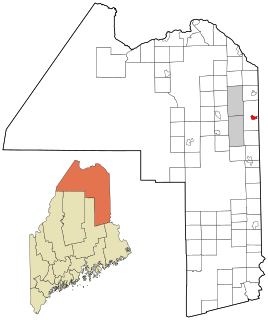
Houlton is a census-designated place (CDP) comprising the main village within the town of Houlton in Aroostook County, Maine, United States. The population of the CDP was 4,856 at the 2010 census, out of a population of 6,123 for the entire town. Houlton is the county seat of Aroostook County. The northern terminus of Interstate 95 and eastern terminus of U.S. Route 2 are just east of the CDP at the Canada–United States border.

Steep Falls is a census-designated place (CDP) in the town of Standish in Cumberland County, Maine, United States. The population was 1,139 at the 2010 census. It is part of the Portland–South Portland–Biddeford, Maine Metropolitan Statistical Area. The town is part of Maine School Administrative District #6, which includes Bonny Eagle Middle and High Schools.
Fort Fairfield is a census-designated place (CDP) comprising the main village within the town of Fort Fairfield in Aroostook County, Maine, United States. The population of the CDP was 1,825 at the 2010 census, out of a population of 3,496 for the entire town.

Fort Kent is a census-designated place (CDP) that comprises the main village in the town of Fort Kent in Aroostook County, Maine. In 2010 Fort Kent's population was 2,488 of 4,097 for the entire town.

Farmington is a census-designated place (CDP) comprising the center of the town of Farmington, which is the county seat of Franklin County in Maine, United States. The population of the CDP was 4,288 at the 2010 census, out of 7,760 people in the town as a whole. The University of Maine at Farmington is located within the CDP.

Falmouth is a census-designated place (CDP) within the town of Falmouth in Cumberland County, Maine, United States. The population was 1,855 at the 2010 census. It is part of the Portland–South Portland–Biddeford, Maine Metropolitan Statistical Area.
Naples is a census-designated place (CDP) in the town of Naples in Cumberland County, Maine, United States. The population of the CDP was 428 at the 2010 census.
Bucksport is a census-designated place (CDP) in the town of Bucksport in Hancock County, Maine, United States. The population was 2,885 at the 2010 census, down from 2,970 at the 2000 census.

Ashland is a census-designated place (CDP) comprising the main village within the town of Ashland in Aroostook County, Maine, United States. The population of the CDP was 709 at the 2010 census, out of a population of 1,309 for the entire town.

Mars Hill is a census-designated place (CDP) comprising the main village within the town of Mars Hill in Aroostook County, Maine, United States. The population of the CDP was 980 at the 2010 census, out of a population of 1,493 for the entire town. Prior to 2010, the village was part of the Mars Hill-Blaine CDP.
Castine is a census-designated place (CDP) in the town of Castine in Hancock County, Maine, United States. The CDP population was 1,029 at the 2010 census, out of 1,366 people in the town as a whole.
Southwest Harbor is a census-designated place (CDP) in the town of Southwest Harbor in Hancock County, Maine, United States. The CDP population was 720 at the 2010 census, out of 1,764 people in the town as a whole.

Damariscotta is a census-designated place (CDP) comprising the main village of the town of Damariscotta in Lincoln County, Maine, United States. The population was 1,142 at the 2010 census, out of 2,218 in the entire town. In the 2000 census, the village was part of the Damariscotta-Newcastle CDP.
Newcastle is a census-designated place (CDP) comprising the main village of the town of Newcastle in Lincoln County, Maine, United States. The population was 667 at the 2010 census, out of 1,752 in the entire town. In the 2000 census, the village was part of the Damariscotta-Newcastle CDP.

Farmingdale is a census-designated place (CDP) in the town of Farmingdale in Kennebec County, Maine, United States. The population was 1,970 at the 2010 census, out of 2,956 in the entire town.

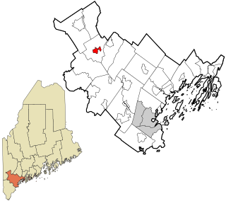
Oakland is a census-designated place (CDP) comprising the main population center in the town of Oakland in Kennebec County, Maine, United States. The population was 2,602 at the 2010 census, out of 6,240 in the entire town of Oakland.

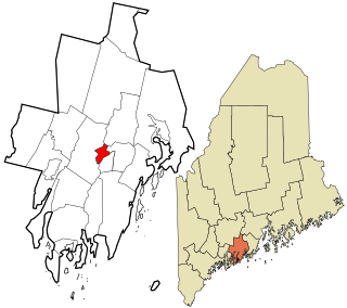
Winthrop is a census-designated place (CDP) comprising the primary settlement in the town of Winthrop in Kennebec County, Maine, United States. The population was 2,650 at the 2010 census, out of 6,092 in the town of Winthrop as a whole.

Waldoboro is a census-designated place (CDP) comprising the central village in the town of Waldoboro in Lincoln County, Maine, United States. The population was 1,233 at the 2010 census, out of 5,075 people in the entire town of Waldoboro.

Wiscasset is a census-designated place (CDP) comprising the primary settlement in the town of Wiscasset in Lincoln County, Maine, United States. The population was 1,097 at the 2010 census, out of 3,732 people in the entire town. Wiscasset is the county seat of Lincoln County.

