Central Aroostook, Maine

Last updated
Central Aroostook, Maine
Aroostook County Maine incorporated and unincorporated areas Central Aroostook highlighted.svg
Location of Central Aroostook, Maine
Coordinates: 46°22′52″N68°11′16″W / 46.38111°N 68.18778°W / 46.38111; -68.18778
Country United States
State Maine
County Aroostook
Area
  Total567.1 sq mi (1,468.7 km2)
  Land556.6 sq mi (1,441.7 km2)
  Water10.4 sq mi (27.0 km2)
Elevation
945 ft (288 m)
Population
 (2020)
  Total164
  Density0.3/sq mi (0.1/km2)
Time zone UTC-5 (Eastern (EST))
  Summer (DST) UTC-4 (EDT)
Area code 207
FIPS code 23-11785
GNIS feature ID582400

Central Aroostook is an unorganized territory in Aroostook County, Maine, United States. The population was 164 at the 2020 census. [1]

Contents

Geography

According to the United States Census Bureau, the unorganized territory has a total area of 567.1 square miles (1,468.7 km2), of which 556.6 square miles (1,441.7 km2) is land and 10.4 square miles (27.0 km2), or 1.84%, is water. [2]

There are 15 townships in the unorganized territory, including Webbertown, St. Croix, Scopan, Swett Farm, Dudley, and E Township. Cox Patent, an area within the township of TDR2 WELS, is also in Central Aroostook.

Demographics

Historical population
CensusPop.Note
1970 82
1980 16−80.5%
1990 53231.3%
2000 9579.2%
2010 11824.2%
2020 16439.0%
U.S. Decennial Census [3]

As of the 2000 census, [4] there were 95 people, 44 households, and 27 families living in the unorganized territory. The population density was 0.2 inhabitants per square mile (0.077/km2). There were 347 housing units, at an average density of 0.6 per square mile (0.23/km2). The racial makeup of the unorganized territory was 98.95% White and 1.05% from two or more races.

There were 44 households, of which 11.4% had children under the age of 18 living with them, 63.6% were married couples living together, and 36.4% were non-families. 31.8% of all households were made up of individuals, and 20.5% had someone living alone who was 65 years of age or older. The average household size was 2.16, and the average family size was 2.61.

In the unorganized territory 11.6% of the population were under the age of 18, 4.2% were 18 to 24, 17.9% were 25 to 44, 43.2% were 45 to 64, and 23.2% were 65 or older. The median age was 49 years. For every 100 females, there were 120.9 males. For every 100 females age 18 and over, there were 115.4 males.

The median income for a household in the unorganized territory was $20,313, and the median income for a family was $22,188. Males had a median income of $21,875, versus $19,375 for females. The per capita income for the unorganized territory was $14,680. There were 30.3% of families and 38.6% of the population living below the poverty line, including 75.0% of those under 18 and 10.5% of those over 64.

Related Research Articles

<span class="mw-page-title-main">Bancroft, Maine</span> Unorganized territory in Maine, United States

Bancroft is a township in Aroostook County, Maine, United States. The population was 57 at the 2020 census. On July 1, 2015 the town voted to deorganize and become part of the unorganized territory of South Aroostook.

<span class="mw-page-title-main">Cary, Maine</span> Township in Maine, United States

Cary is an unorganized township in Aroostook County, Maine, United States, and part of the state's Unorganized Territory. As of the 2010 census, it had a population of 218.

<span class="mw-page-title-main">Connor, Maine</span> Unorganized territory in Maine, United States

Connor is an unorganized territory (township) in Aroostook County, Maine, United States. The population was 418 at the 2020 census. It is the location of a former Nike missile site and the Blotner Radar Site.

<span class="mw-page-title-main">Northwest Aroostook, Maine</span> Unorganized territory in Maine, United States

Northwest Aroostook is an unorganized territory in Aroostook County, Maine, United States. The population was 12 at the 2020 census.

<span class="mw-page-title-main">South Aroostook, Maine</span> Unorganized territory in Maine, United States

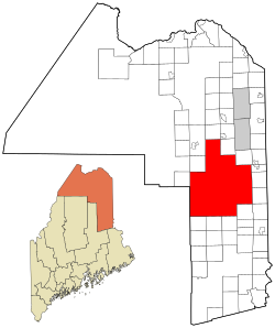
South Aroostook is an unorganized territory in Aroostook County, Maine, United States. The population was 579 at the 2020 census.

<span class="mw-page-title-main">Square Lake, Maine</span> Unorganized territory in Maine, United States

Square Lake is an unorganized territory in Aroostook County, Maine, United States. The population was 706 at the 2020 census.

<span class="mw-page-title-main">East Central Franklin, Maine</span> Unorganized territory in Maine, United States

East Central Franklin is an unorganized territory in Franklin County, Maine, United States. The population was 805 at the 2020 census.

Wyman is an unorganized territory in Franklin County, Maine, United States. The population was 82 at the 2020 census. It is designated as Township 4 Range 3 of Bingham's Kennebec Purchase.

Central Hancock, also known as Fletchers Landing, is an unorganized territory (township) in Hancock County, Maine, United States. The population was 132 at the 2020 census. The territory is designated as Township 8 Southern Division.

East Hancock is an unorganized territory in Hancock County, Maine, United States. The population was 85 at the 2020 census.

Milton is an unorganized territory (township) in Oxford County, Maine, United States. The population was 150 at the 2020 census. The township was formerly a plantation that surrendered its organization in 1939.

<span class="mw-page-title-main">South Oxford, Maine</span> Unorganized territory in Maine, United States

South Oxford is an unorganized territory located in Oxford County, Maine, United States. The population was 591 at the 2020 census. The unorganized territory encompasses the areas designated under state law as Albany Township, Mason Township, and Batchelder's Grant. Albany and Mason were formerly incorporated as towns. Albany disincorporated in 1937 while Mason disincorporated in 1935.

Argyle is an unorganized territory (township) in Penobscot County, Maine, United States. The population was 255 at the 2020 census.

East Central Penobscot is an unorganized territory in Penobscot County, Maine, United States. The population was 308 at the 2020 census.

Kingman is an unorganized territory (township) in Penobscot County, Maine, United States. The population was 137 at the 2020 census.

North Penobscot is an unorganized territory in Penobscot County, Maine, United States. The population was 405 at the 2020 census.

Prentiss is an unorganized territory (township) in Penobscot County, Maine, United States. The township was named for Henry Prentiss, an early landowner. The population was 169 at the 2020 census.

East Central Washington is an unorganized territory in Washington County, Maine, United States. The population was 724 at the 2020 census.

North Washington is an unorganized territory in Washington County, Maine, United States. The population was 505 at the 2020 census.

<span class="mw-page-title-main">Unity, Kennebec County, Maine</span> Unorganized territory in Maine, United States

Unity is an unincorporated territory (township) in Kennebec County, Maine, United States. The population was 36 at the 2020 census. The township was a former plantation that surrendered its organization in 1942.

References

  1. "Census - Geography Profile: Central Aroostook UT, Aroostook County, Maine". United States Census Bureau . Retrieved March 16, 2022.
  2. "Geographic Identifiers: 2010 Demographic Profile Data (G001): Central Aroostook UT, Aroostook County, Maine". U.S. Census Bureau, American Factfinder. Archived from the original on February 12, 2020. Retrieved May 21, 2013.
  3. "Census of Population and Housing". Census.gov. Retrieved June 4, 2015.
  4. "U.S. Census website". United States Census Bureau . Retrieved 2008-01-31.