Connor, Maine

Last updated
Connor, Maine
Aroostook County Maine incorporated and unincorporated areas Connor highlighted.svg
Location of Connor, Maine
Coordinates: 47°00′N68°00′W / 47.000°N 68.000°W / 47.000; -68.000
Country United States
State Maine
County Aroostook
Area
  Total39.4 sq mi (102.1 km2)
  Land39.3 sq mi (101.9 km2)
  Water0.077 sq mi (0.2 km2)
Elevation
748 ft (228 m)
Population
 (2020)
  Total418
  Density11/sq mi (4.1/km2)
Time zone UTC-5 (Eastern (EST))
  Summer (DST) UTC-4 (EDT)
ZIP code
04736
Area code 207
FIPS code 23-13900
GNIS feature ID2378259 [1]

Connor is an unorganized territory (township) in Aroostook County, Maine, United States. The population was 418 at the 2020 census. [2] It is the location of a former Nike missile site and the Blotner Radar Site. [3]

Contents

Geography

According to the United States Census Bureau, the unorganized territory has a total area of 39.4 square miles (102.1 km2), of which 39.3 square miles (101.9 km2) is land and 0.077 square miles (0.2 km2), or 0.22%, is water. [4]

Demographics

Historical population
CensusPop.Note
1880 253
1890 526107.9%
1900 453−13.9%
1910 60934.4%
1920 585−3.9%
1930 6267.0%
1940 73918.1%
1950 630−14.7%
1970 575
1980 574−0.2%
1990 468−18.5%
2000 424−9.4%
2010 4577.8%
2020 418−8.5%
U.S. Decennial Census [5]

At the 2000 census there were 424 people, 162 households, and 127 families living in the unorganized territory. The population density was 10.8 inhabitants per square mile (4.2/km2). There were 193 housing units at an average density of 4.9 per square mile (1.9/km2). The racial makeup of the unorganized territory was 97.88% White, 0.71% Native American, and 1.42% from two or more races. [6] Of the 162 households 35.2% had children under the age of 18 living with them, 64.2% were married couples living together, 4.9% had a female householder with no husband present, and 21.0% were non-families. 14.2% of households were one person and 6.8% had someone living alone who was 65 years of age or older. The average household size was 2.62 and the average family size was 2.83.

The age distribution was 26.4% under the age of 18, 4.5% from 18 to 24, 30.7% from 25 to 44, 28.3% from 45 to 64, and 10.1% who were 65 years of age or older. The median age was 39 years. For every 100 females there were 104.8 males. For every 100 females age 18 and over, there were 97.5 males.

The median household income was $25,417 and the median family income was $26,818. Males had a median income of $22,917 versus $18,182 for females. The per capita income for the unorganized territory was $12,748. About 5.9% of families and 11.8% of the population were below the poverty line, including 11.8% of those under age 18 and 23.3% of those age 65 or over.

Related Research Articles

<span class="mw-page-title-main">Bancroft, Maine</span> Unorganized territory in Maine, United States

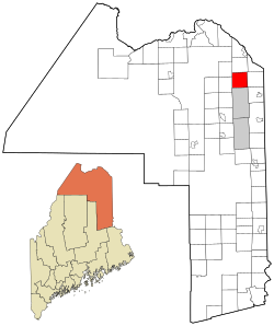
Bancroft is a township in Aroostook County, Maine, United States. The population was 57 at the 2020 census. On July 1, 2015 the town voted to deorganize and become part of the unorganized territory of South Aroostook.

<span class="mw-page-title-main">Cary, Maine</span> Township in Maine, United States

Cary is an unorganized township in Aroostook County, Maine, United States, and part of the state's Unorganized Territory. As of the 2010 census, it had a population of 218.

<span class="mw-page-title-main">Central Aroostook, Maine</span> Unorganized territory in Maine, United States

Central Aroostook is an unorganized territory in Aroostook County, Maine, United States. The population was 164 at the 2020 census.

<span class="mw-page-title-main">Northwest Aroostook, Maine</span> Unorganized territory in Maine, United States

Northwest Aroostook is an unorganized territory in Aroostook County, Maine, United States. The population was 12 at the 2020 census.

<span class="mw-page-title-main">South Aroostook, Maine</span> Unorganized territory in Maine, United States

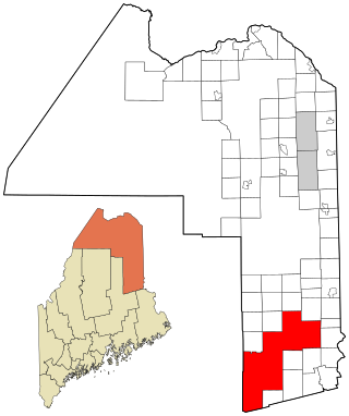
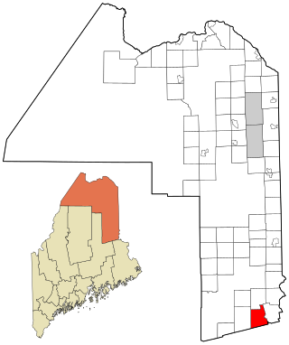
South Aroostook is an unorganized territory in Aroostook County, Maine, United States. The population was 579 at the 2020 census.

<span class="mw-page-title-main">Square Lake, Maine</span> Unorganized territory in Maine, United States

Square Lake is an unorganized territory in Aroostook County, Maine, United States. The population was 706 at the 2020 census.

<span class="mw-page-title-main">East Central Franklin, Maine</span> Unorganized territory in Maine, United States

East Central Franklin is an unorganized territory in Franklin County, Maine, United States. The population was 805 at the 2020 census.

North Franklin is an unorganized territory in Franklin County, Maine, United States. The population was 41 at the 2020 census. The territory consists of 13 townships and three gores, namely Lang, Davis, Tim Pond, Stetsontown, Jim Pond, Alder Stream, Seven Ponds, Kibby, Chain of Ponds, Massachusetts Gore, Coburn Gore, Skinner, Merrill Strip, Lowelltown, Gorham Gore, and Beattie.

South Franklin is an unorganized territory in Franklin County, Maine, United States. The population was 60 at the 2020 census.

Wyman is an unorganized territory in Franklin County, Maine, United States. The population was 82 at the 2020 census. It is designated as Township 4 Range 3 of Bingham's Kennebec Purchase.

Central Hancock, also known as Fletchers Landing, is an unorganized territory (township) in Hancock County, Maine, United States. The population was 132 at the 2020 census. The territory is designated as Township 8 Southern Division.

East Hancock is an unorganized territory in Hancock County, Maine, United States. The population was 85 at the 2020 census.

<span class="mw-page-title-main">South Oxford, Maine</span> Unorganized territory in Maine, United States

South Oxford is an unorganized territory located in Oxford County, Maine, United States. The population was 591 at the 2020 census. The unorganized territory encompasses the areas designated under state law as Albany Township, Mason Township, and Batchelder's Grant. Albany and Mason were formerly incorporated as towns. Albany disincorporated in 1937 while Mason disincorporated in 1935.

Kingman is an unorganized territory (township) in Penobscot County, Maine, United States. The population was 137 at the 2020 census.

North Penobscot is an unorganized territory in Penobscot County, Maine, United States. The population was 405 at the 2020 census.

Prentiss is an unorganized territory (township) in Penobscot County, Maine, United States. The township was named for Henry Prentiss, an early landowner. The population was 169 at the 2020 census.

<span class="mw-page-title-main">Northeast Piscataquis, Maine</span> Unorganized territory in Maine, United States

Northeast Piscataquis is an unincorporated area in Piscataquis County, Maine, United States. The population was 304 at the 2020 census.

East Central Washington is an unorganized territory in Washington County, Maine, United States. The population was 724 at the 2020 census.

North Washington is an unorganized territory in Washington County, Maine, United States. The population was 505 at the 2020 census.

<span class="mw-page-title-main">Unity, Kennebec County, Maine</span> Unorganized territory in Maine, United States

Unity is an unincorporated territory (township) in Kennebec County, Maine, United States. The population was 36 at the 2020 census. The township was a former plantation that surrendered its organization in 1942.

References

  1. "Unorganized Territory of Connor". Geographic Names Information System . United States Geological Survey, United States Department of the Interior. 11 February 2008. Retrieved 2010-04-13.
  2. "Geographic Identifiers: Census - Geography Profile: Connor UT, Aroostook County, Maine". United States Census Bureau . Retrieved March 16, 2022.
  3. "Locations of Former NIKE MISSILE SITES (text)" . Retrieved 2013-04-01. GPS 47-00-41, 68-01-11…16-unit housing area at[ verification needed ] was transferred to the Air Force and became Loring Family Housing Annex No. 3, NRCX
  4. "Geographic Identifiers: 2010 Demographic Profile Data (G001): Connor UT, Aroostook County, Maine". U.S. Census Bureau, American Factfinder. Archived from the original on February 12, 2020. Retrieved May 22, 2013.
  5. "Census of Population and Housing". Census.gov. Retrieved June 4, 2015.
  6. "U.S. Census website". United States Census Bureau . Retrieved 2008-01-31.