Madawaska (CDP), Maine

Last updated

Madawaska, Maine
Madawaska ME 1.JPG
Aroostook County Maine incorporated and unincorporated areas Madawaska (CDP) highlighted.svg
Location of Madawaska, Maine
Coordinates: 47°21′10″N68°19′51″W / 47.35278°N 68.33083°W / 47.35278; -68.33083
CountryUnited States
State Maine
County Aroostook
Town Madawaska
Area
[1]
  Total5.39 sq mi (13.97 km2)
  Land5.29 sq mi (13.70 km2)
  Water0.10 sq mi (0.26 km2)
Elevation
574 ft (175 m)
Population
 (2020)
  Total2,797
  Density528.63/sq mi (204.09/km2)
Time zone UTC-5 (Eastern (EST))
  Summer (DST) UTC-4 (EDT)
ZIP code
04756
Area code 207
FIPS code 23-42485
GNIS feature ID0570640

Madawaska is a census-designated place (CDP) comprising the main village within the town of Madawaska in Aroostook County, Maine, United States. The population of the CDP was 2,967 at the 2010 census, [2] out of a population of 4,035 for the entire town.

Contents

Geography

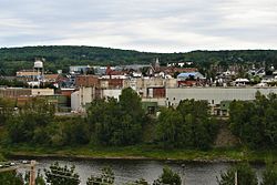
The Madawaska CDP is located at 47°21′9″N68°19′51″W / 47.35250°N 68.33083°W / 47.35250; -68.33083 (47.352645, −68.330943) [3] in the northwestern corner of the town of Madawaska. The Saint John River forms the northern edge of the CDP as well as the Canada–United States border. U.S. Route 1 runs east–west through the center of the CDP, leading 19 miles (31 km) southwest (officially northbound) to Fort Kent, the highway's northern terminus, and 47 miles (76 km) southeast (southbound) to Caribou. A bridge across the Saint John River connects Madawaska with the city of Edmundston, New Brunswick, Canada. The Madawaska River of New Brunswick joins the Saint John River just east (downstream) of the international bridge.

According to the United States Census Bureau, the Madawaska CDP has a total area of 5.4 square miles (14.0 km2), of which 5.3 square miles (13.7 km2) is land and 0.12 square miles (0.3 km2), or 1.89%, is water. [2]

Demographics

Historical population
CensusPop.Note
2020 2,797
U.S. Decennial Census [4]
Languages (2000) [5] Percent
Spoke French at home83.54%
Spoke English at home16.46%

As of the census [6] of 2000, there were 3,326 people, 1,523 households, and 927 families residing in the CDP. The population density was 629.8 inhabitants per square mile (243.2/km2). There were 1,667 housing units at an average density of 315.7 per square mile (121.9/km2). The racial makeup of the CDP was 98.11% White, 0.09% Black or African American, 0.51% Native American, 0.66% Asian, 0.12% from other races, and 0.51% from two or more races. Hispanic or Latino of any race were 0.18% of the population.

There were 1,523 households, out of which 23.1% had children under the age of 18 living with them, 52.7% were married couples living together, 6.3% had a female householder with no husband present, and 39.1% were non-families. 35.5% of all households were made up of individuals, and 16.0% had someone living alone who was 65 years of age or older. The average household size was 2.11 and the average family size was 2.73.

In the CDP, the population was spread out, with 18.7% under the age of 18, 5.3% from 18 to 24, 23.7% from 25 to 44, 30.4% from 45 to 64, and 21.9% who were 65 years of age or older. The median age was 46 years. For every 100 females, there were 86.4 males. For every 100 females age 18 and over, there were 85.3 males.

The median income for a household in the CDP was $30,605, and the median income for a family was $43,287. Males had a median income of $47,429 versus $23,233 for females. The per capita income for the CDP was $17,657. About 4.4% of families and 9.1% of the population were below the poverty line, including 7.8% of those under age 18 and 12.6% of those age 65 or over.

Related Research Articles

Four Mile Road is a census-designated place (CDP) in Yukon-Koyukuk Census Area, Alaska, United States. The population was 43 at the 2010 census, up from 38 in 2000.

<span class="mw-page-title-main">Picture Rocks, Arizona</span> CDP in Pima County, Arizona

Picture Rocks is a census-designated place (CDP) in Pima County, Arizona, United States, home of the Tucson artifacts. The population was 9,551 at the 2020 United States census.

<span class="mw-page-title-main">Fort Pierce South, Florida</span> CDP in Florida, United States

Fort Pierce South is a census-designated place (CDP) in St. Lucie County, Florida, United States. The population was 5,062 at the 2010 census. It is part of the Port St. Lucie Metropolitan Statistical Area.

<span class="mw-page-title-main">Lake Summerset, Illinois</span> Census Designated Place in Illinois, United States

Lake Summerset is a census-designated place (CDP) in Stephenson and Winnebago counties in Illinois. The population was 2,048 at the 2010 census.

<span class="mw-page-title-main">Four Corners, Montana</span> Census-designated place in Montana, United States

Four Corners is a census-designated place (CDP) in Gallatin County, Montana, United States. The population was 5,901 at the 2020 census, up from 3,146 in 2010. It is part of the Bozeman, MT Micropolitan Statistical Area.

<span class="mw-page-title-main">Indian Hills, Texas</span> Census-designated place in Texas

Indian Hills is a census-designated place (CDP) in Hidalgo County, Texas, United States. At the 2010 United States Census, the population was 2,591. It is part of the McAllen–Edinburg–Mission Metropolitan Statistical Area.

<span class="mw-page-title-main">Maple Heights-Lake Desire, Washington</span> Census-designated place in Washington, United States

Maple Heights-Lake Desire is a census-designated place (CDP) in King County, Washington, United States. At the 2010 census, the population was 3,152.

<span class="mw-page-title-main">Riverbend, Washington</span> Census-designated place in Washington, United States

Riverbend is an unincorporated community and census-designated place (CDP) in King County, Washington, United States. The population was 2,132 at the 2010 census.

<span class="mw-page-title-main">Riverton-Boulevard Park, Washington</span> Former CDP in Washington, United States

Riverton-Boulevard Park is a former census-designated place (CDP) in King County, Washington, United States. The population was 11,188 at the 2000 census. For the 2010 census, the CDP was separated into the Riverton and Boulevard Park CDPs, with part of the area now being in the city of Tukwila.

<span class="mw-page-title-main">Lake Roesiger, Washington</span> CDP in Washington, United States

Lake Roesiger is a census-designated place (CDP) in Snohomish County, Washington, United States. The population was 503 at the 2010 census.

<span class="mw-page-title-main">Warm Beach, Washington</span> CDP in Washington, United States

Warm Beach is a census-designated place (CDP) in Snohomish County, Washington, United States. The population was 2,437 at the 2010 census.

<span class="mw-page-title-main">Satus, Washington</span> CDP in Washington, United States

Satus is a census-designated place (CDP) in Yakima County, Washington, United States, located on the eastern corner of the Yakama Indian Reservation. The population was 746 at the 2000 census. It is southwest from the Toppenish National Wildlife Refuge. The community was not recognized in the 2010 census. The area was first settled and established as a post office location in 1890.

<span class="mw-page-title-main">Van Buren (CDP), Maine</span> Census-designated place in Maine, United States

Van Buren is a census-designated place (CDP) comprising the main village within the town of Van Buren in Aroostook County, Maine, United States. The population of the CDP was 1,937 at the 2010 census, out of a population of 2,171 for the entire town.

Gorham is a census-designated place (CDP) and the main village in the town of Gorham in Coos County, New Hampshire, United States. The population of the CDP was 1,851 at the 2020 census, out of 2,698 people in the entire town of Gorham.

<span class="mw-page-title-main">Glastonbury Center, Connecticut</span> Census-designated place in Connecticut, United States

Glastonbury Center is a census-designated place (CDP) that constitutes the densely populated center of the town of Glastonbury in Hartford County, Connecticut, United States. The population was 7,387 at the 2010 census, out of a total town population of 34,427.

<span class="mw-page-title-main">Madawaska, Maine</span> Town in the state of Maine, United States

Madawaska is a town in Aroostook County, Maine, United States. The population was 3,867 at the 2020 census. Madawaska is opposite Edmundston, Madawaska County in New Brunswick, Canada, to which it is connected by the Edmundston–Madawaska Bridge over the Saint John River. The majority of its residents speak French; 83.4% of the population speak French at home.

<span class="mw-page-title-main">Fort Kent (CDP), Maine</span> Census-designated place in Maine, United States

Fort Kent is a census-designated place (CDP) that comprises the main village in the town of Fort Kent in Aroostook County, Maine, United States. In 2010, Fort Kent's population was 2,488 of 4,097 for the entire town.

Bucksport is a census-designated place (CDP) in the town of Bucksport in Hancock County, Maine, United States. The population was 2,885 at the 2010 census, down from 2,970 at the 2000 census.

Orono is a census-designated place (CDP) consisting of the eastern portion of the town of Orono in Penobscot County, Maine, United States. The population of the CDP was 9,474 at the 2010 census.

<span class="mw-page-title-main">Milo (CDP), Maine</span> CDP in Maine, United States

Milo is a census-designated place (CDP) in the town of Milo in Piscataquis County, Maine, United States. The population was 1,898 at the 2000 census.

References

  1. "2020 U.S. Gazetteer Files". United States Census Bureau. Retrieved April 8, 2022.
  2. 1 2 "Geographic Identifiers: 2010 Demographic Profile Data (G001): Madawaska CDP, Maine". U.S. Census Bureau, American Factfinder. Archived from the original on February 12, 2020. Retrieved May 22, 2013.
  3. "US Gazetteer files: 2010, 2000, and 1990". United States Census Bureau. February 12, 2011. Retrieved April 23, 2011.
  4. "Census of Population and Housing". Census.gov. Retrieved June 4, 2016.
  5. "Data Center Results". apps.mla.org.
  6. "U.S. Census website". United States Census Bureau . Retrieved January 31, 2008.