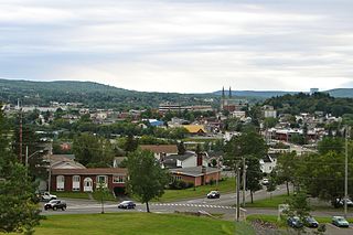
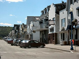
Clair, New Brunswick

Last updated

Clair
Clair NB flag.gif
Motto: 
"Quousque Possumus"
Canada New Brunswick location map 2.svg
Red pog.svg
Location of Clair, New Brunswick
Coordinates: 47°15′09″N68°36′18″W / 47.2525°N 68.605°W / 47.2525; -68.605
Country Flag of Canada (Pantone).svg  Canada
Province Flag of New Brunswick.svg  New Brunswick
County Madawaska
Parish Clair
Village Status 1966
Electoral Districts   
Federal

Madawaska—Restigouche
Provincial Madawaska-les-Lacs
Government
[1]
  TypeVillage Council
  MayorPierre Michaud
  Councillors
List of Members
  • Patrick P. Long
  • Marc R. Long
  • Carl Sawyer
Area
[2]
  Total10.61 km2 (4.10 sq mi)
Population
 (2016) [2]
  Total781
  Density73.6/km2 (191/sq mi)
  Change 2011-16
Decrease2.svg8.9%
Time zone UTC-4 (AST)
  Summer (DST) UTC-3 (ADT)
Area code 506
Dwellings409
Median Household Income*$44,544 CDN
Access RoutesNB 161.svg Route 161
NB 205.svg Route 205
  • Median household income, 2015 (all households)

Clair (2016 population: 781 [2] ) is a former Canadian village in Madawaska County, New Brunswick. [3]

Contents

History

Situated on the Saint John River opposite Fort Kent, Maine. The name Clair finds its roots in the community named for County Clare in Ireland. The name of the village is the result of the railroad station being located near the General store of James T. Clair. The station was called Clair's and was a regular stop of the Temiscouata Railway on its way up to the Connors station. Over time, the name stuck and was shortened to the family name of Clair. The original name of the location was actually "La Petite Décharge" named after the discharge of the small "ruisseau des Lang" into the Saint John River.

Forestry is the basis of the local economy.

The Clair – Fort Kent Bridge crosses the International Boundary to link both communities.

Demographics

Attractions

The local Roman Catholic church houses noted religious artwork, including stained-glass windows from the workshop of Belgian artist José Gaterrath and the Stations of the Cross by the famous Spanish ceramist Jordi Bonet.

Notable people

See also

Related Research Articles

<span class="mw-page-title-main">Madawaska County, New Brunswick</span> County in New Brunswick, Canada

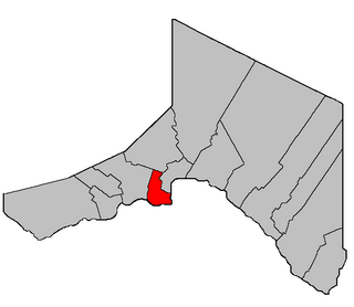
Madawaska County, also known as the "New Brunswick Panhandle", is located in northwestern New Brunswick, Canada. Over 90% of the county's population speaks French. Its Francophone population are known as "Brayons." Forestry is the major industry in the county.

<span class="mw-page-title-main">Baker-Brook, New Brunswick</span> Village in New Brunswick, Canada

Baker-Brook is a former village in Madawaska County, New Brunswick, Canada.

Esgenoôpetitj is a Mi'kmaq Indian reserve in Northumberland County, New Brunswick, Canada. Prior to July 11, 2012, the Indian reserve was named Burnt Church 14.

<span class="mw-page-title-main">Dundas Parish, New Brunswick</span> Parish in Canada

Dundas is a geographic parish in Kent County, New Brunswick, Canada.

Belledune is a port village in the Canadian province of New Brunswick. It has a population of 1,325, and straddles the boundary between Restigouche County and Gloucester County, New Brunswick.

Balmoral is a former village in Restigouche County, New Brunswick, Canada. It held village status prior to 2023 and is now part of the village of Bois-Joli. It is approximately 10 kilometres south of Dalhousie. Balmoral also contains the neighbourhoods of Blair Athol, Saint-Maure, Selwood, and Upper Balmoral.

Kedgwick is a Canadian incorporated rural community in northern New Brunswick, Canada. On 1 January 2023, Kedgwick annexed a large area including the local service districts of St. Jean Baptiste – Menneval and White's Brook, with parts of two others; revised census figures have not been released.

<span class="mw-page-title-main">Saint-François-de-Madawaska, New Brunswick</span> Village in New Brunswick, Canada

Saint-François-de-Madawaska is a former Canadian village in Madawaska County, New Brunswick.

Saint-Hilaire is a former Canadian village in Madawaska County, New Brunswick. It is now part of Haut-Madawaska.

<span class="mw-page-title-main">Saint-Léonard, New Brunswick</span> Place in New Brunswick, Canada

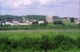
Saint-Léonard is a former town in Madawaska County, New Brunswick, Canada. It held town status prior to 2023 and is now part of the town of Vallée-des-Rivières.

<span class="mw-page-title-main">Sainte-Anne-de-Madawaska, New Brunswick</span> Place in New Brunswick, Canada

Sainte-Anne-de-Madawaska is a former village in Madawaska County, New Brunswick, Canada. It held village status prior to 2023 and is now part of the town of Vallée-des-Rivières.

<span class="mw-page-title-main">Grimmer Parish, New Brunswick</span> Former Parish in New Brunswick, Canada

Grimmer is a geographic parish in Restigouche County, New Brunswick, Canada.

<span class="mw-page-title-main">Caraquet Parish, New Brunswick</span> Parish in New Brunswick, Canada

Caraquet is a geographic parish in Gloucester County, New Brunswick, Canada.

<span class="mw-page-title-main">Saint-François Parish, New Brunswick</span> Parish in New Brunswick, Canada

Saint-François is a geographic parish in Madawaska County, New Brunswick, Canada.

<span class="mw-page-title-main">Lac Baker Parish, New Brunswick</span> Parish in New Brunswick, Canada

Lac Baker is a geographic parish in Madawaska County, New Brunswick, Canada.

<span class="mw-page-title-main">Clair Parish, New Brunswick</span> Parish in New Brunswick, Canada

Clair is a geographic parish in Madawaska County, New Brunswick, Canada.

<span class="mw-page-title-main">Saint-Hilaire Parish, New Brunswick</span> Parish in New Brunswick, Canada

Saint-Hilaire is a geographic parish in Madawaska County, New Brunswick, Canada.

<span class="mw-page-title-main">Saint-Charles Parish, New Brunswick</span> Parish in New Brunswick, Canada

Saint-Charles is a geographic parish in Kent County, New Brunswick, Canada.

<span class="mw-page-title-main">Caraquet</span> Town in New Brunswick, Canada

Caraquet is a town in Gloucester County, New Brunswick, Canada.

<span class="mw-page-title-main">Fort Kent (CDP), Maine</span> Census-designated place in Maine, United States

Fort Kent is a census-designated place (CDP) that comprises the main village in the town of Fort Kent in Aroostook County, Maine, United States. In 2010, Fort Kent's population was 2,488 of 4,097 for the entire town.

References

  1. "Clair - Community Profile". 11 June 2011. Archived from the original on 11 June 2011.
  2. 1 2 3 4 5 "Census Profile, 2016 Census Clair, Village [Census subdivision], New Brunswick". Statistics Canada. Retrieved September 21, 2019.
  3. "Provincial Archives of New Brunswick". archives.gnb.ca.
  4. Statistics Canada: 1996, 2001, 2006 census, 2011 census
  5. "File not found". www12.statcan.ca.[ permanent dead link ]


47°15′09″N68°36′18″W / 47.25250°N 68.60500°W / 47.25250; -68.60500 (Clair)