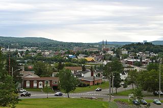
Edmundston is a city in Madawaska County, New Brunswick, Canada. Established in 1850, it had a population of 16,437 as of 2021.

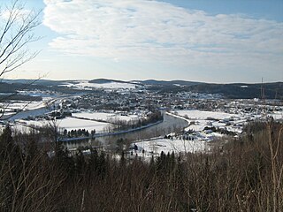
Madawaska County, also known as the "New Brunswick Panhandle", is located in northwestern New Brunswick, Canada. Over 90% of the county's population speaks French. Its Francophone population are known as "Brayons." Forestry is the major industry in the county.
Route 2 is a major provincial highway in the Canadian province of New Brunswick, carrying the main route of the Trans-Canada Highway in the province. The highway connects with Autoroute 85 at the border with Quebec and Highway 104 at the border with Nova Scotia, as well as with traffic from Interstate 95 in the U.S. state of Maine via the short Route 95 connector. A core route in the National Highway System, Route 2 is a four-lane freeway in its entirety, and directly serves the cities of Edmundston, Fredericton, and Moncton.
The Madawaska River flows from Lake Témiscouata in Quebec, through Degelis, Quebec, to join the Saint John River at Edmundston, New Brunswick.

Clair is a former Canadian village in Madawaska County, New Brunswick.

Saint-François-de-Madawaska is a former Canadian village in Madawaska County, New Brunswick.
Saint-Hilaire is a former Canadian village in Madawaska County, New Brunswick. It is now part of Haut-Madawaska.
Route 161 is a New Brunswick highway that runs for 5 kilometres (3.1 mi) from a junction with Route 120 at Caron Brook, to the International Bridge at Clair; in Madawaska County. The route connects to U.S. Route 1 and Maine State Route 161 across the Saint John River in Fort Kent, Maine.

The St. Francis River is a river roughly 75 miles (120 km) long, which forms part of the Canada–United States border. The river rises in a lake of the same name located 12 miles (20 km) east of the Rivière du Loup in Quebec. The portion that forms the boundary starts at the bottom of Lake Pohenegamook at the very northernmost point of New England between Estcourt Station, Maine, and Estcourt, Quebec. The river along the international boundary flows south and then south-east through two deep, narrow lakes to its mouth on the Saint John River at St. Francis, Maine/Saint-François-de-Madawaska, New Brunswick.

U.S. Route 1 (US 1) in the U.S. state of Maine is a major north–south section of the United States Numbered Highway System, serving the eastern part of the state. It parallels the Atlantic Ocean from New Hampshire north through Portland, Brunswick, and Belfast to Calais, and then the St. Croix River and the rest of the Canada–United States border via Houlton to Fort Kent. The portion along the ocean, known as the Coastal Route, provides a scenic alternate to Interstate 95 (I-95).
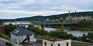
The Edmundston–Madawaska Bridge is an international bridge which connects the cities of Edmundston, New Brunswick, in Canada and Madawaska, Maine, in the United States, across the Saint John River. The bridge consists of four steel through truss spans, each 70.71 metres (232.0 ft) in length, for a total length of 287.12 metres (942.0 ft), which carries a two lane open steel grid deck roadway.
Route 215 is a 15 km (9.3 mi) local highway in northwestern New Brunswick, Canada.
Route 120 is a New Brunswick highway in Madawaska County that runs from a junction with Quebec Route 289 at Saint-Jean-de-la-Lande, Quebec, to New Brunswick Route 2 in Edmundston.
Saint-François is a civil parish in Madawaska County, New Brunswick, Canada.

Clair is a civil parish in Madawaska County, New Brunswick, Canada.
The Iroquois River is a tributary of the Saint John River emptying in New Brunswick, in Canada. This river flows into the Notre Dame Mountains, in the municipality of Dégelis, Quebec, in Temiscouata Regional County Municipality (RCM), in administrative region of Bas-Saint-Laurent, in Quebec; and in the Madawaska County, in New Brunswick, in Canada.

The Baker-Brook River is a tributary of the Saint John River, flowing in Madawaska County, in the northwest part of the New Brunswick, in Canada.
The Crocs River is a tributary of the Saint John River, in Quebec and New Brunswick, in Canada. The Crocs River flows in the southern part of the Gaspé Peninsula, across the following areas:
Haut-Madawaska is a town in the New Brunswick Panhandle, Canada, formed by amalgamating the previous incorporated rural community of the same name with the village of Lac Baker. The town includes the former incorporated villages of Lac Baker, Baker-Brook, Clair, Saint-François de Madawaska and Saint-Hilaire.
