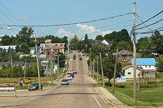
Route 8 is an important highway link between northern and southern New Brunswick, Canada. 261 kilometres (162 mi) long, it runs from Fredericton to Bathurst via Miramichi.

Route 11 is a provincial highway in northeastern New Brunswick, Canada. The 440-kilometre (270 mi) road runs from Moncton to the Quebec border, near Campbellton, at the Interprovinciale Bridge, following the province's eastern and northern coastlines.
Route 15 is 79 kilometres (49 mi) long and is in the southeastern corner of the province of New Brunswick. Starting at the north end of the Petitcodiac River Causeway, it loops around the city of Moncton on Wheeler Boulevard, then turns northeast from Dieppe to Shediac. From there, it turns east and bypasses Cap-Pelé crossing the Scoudouc River, then southeast to meet the Trans-Canada Highway at Port Elgin. The highway is a divided freeway from Moncton to just east of Shediac, where it remains a controlled-access highway until east of Cap-Pele.

Parlee Beach Provincial Park is a provincial park located in Pointe-du-Chêne, New Brunswick, Canada.

Beaubassin East is a Canadian Rural Community in Westmorland County, New Brunswick. The French form of the name is Beaubassin-Est.
Victor E. Boudreau is a New Brunswick politician. He was a member of the Legislative Assembly of New Brunswick from 2014 to 2018, representing the ridings of Shediac-Cap-Pelé and Shediac-Beaubassin-Cap-Pelé for the New Brunswick Liberal Association, and was the Leader of the Opposition in the legislature.

Route 132 is a New Brunswick provincial collector road that runs 27 kilometres (17 mi) between Dieppe and Shediac.

Route 114 is a 137.6 km (85.5 mi) Canadian secondary highway in southeastern New Brunswick.
Route 134 is a 261 km (162 mi)-long north–south secondary highway in eastern New Brunswick, Canada. The highway is divided by into a northern and southern section by a gap in Northumberland County connected by Route 11 and Route 8.
Route 945 is a Canadian highway in Westmorland County, New Brunswick.
Greater Shediac is the name given to the area encompassing the Town of Shediac in New Brunswick, Canada and its surroundings. Most of this area is a tourist area along the Northumberland Strait mainly on portions of Route 134, Route 133 and Route 950. Some of the areas mentioned below are included in the area of Greater Moncton.
Route 117 is an East/West provincial highway in the Canadian province of New Brunswick. The road runs from Route 11 intersection in Saint-Louis. The road has a length of approximately 114 kilometres, and services small, otherwise isolated rural communities. In these areas, the highway is often unofficially referred to as "Main Street." The Road is called Loggie Road, Wellington Street, University Avenue, and Airport Road in the city of Miramichi. This Route Mainly follows the Gulf of St. Lawrence in New Brunswick.
Route 121 is a mostly north/south provincial highway in the Canadian province of New Brunswick, although it's signed as an east/west highway. The road runs from the Route 1 intersection in Hampton. The road is approximately 40 kilometres, and services small, otherwise isolated, rural communities. In these areas, the highway is often unofficially referred to as "Main Street." The road parallels Route 1 and follows the Kennebecasis River. The highway starts in Hampton as Hall Road, then Main Street. It is also called Main Street in Sussex.
Route 122 is a mostly East/West provincial highway in the Canadian province of New Brunswick. The road runs from Route 2 and Route 165 intersection in Dow Settlement. The road has a length of approximately 44 kilometres, and services small, otherwise isolated rural communities. In these areas, the highway is often unofficially referred to as "Main Street." The road bypasses several Lakes including Skiff Lake, Mud Lake, Eel River Lake, North Lake and finally Grand Lake before changing to Boundary Road in Orient, Maine at the Canada–United States border. The Highway is known as Canterbury Road between Meductic and Canterbury.
Route 123 is a mostly North/South provincial highway in the Canadian province of New Brunswick. The road runs from Route 10 in Chipman. The road has a length of approximately 52 kilometres, and services small, otherwise isolated rural communities. In these areas, the highway is often unofficially referred to as "Main Street." The Highway is known as Main Street and McLeod Avenue in Chipman. The road is then known as Grand Lake Road from Gaspereau Forks to Doaktown. Lastly upon entering Doaktown, the road is named South Road.
Route 130 is a mostly north/south provincial highway in the Canadian province of New Brunswick. The road has a length of approximately 108 kilometres, and services small, otherwise isolated rural communities. In these areas, the highway is often unofficially referred to as "Main Street." The highway is known as Broadway and Portage Road in Grand Falls, and West Riverside Drive in Perth-Andover.
Route 440 is a 10-kilometre (6.2 mi) long mostly North–South secondary highway in the northwest portion of New Brunswick, Canada.
Route 530 is a 22-kilometre (14 mi) long north-east looping secondary highway in the southeast portion of New Brunswick, Canada.

Shediac is a civil parish in Westmorland County, New Brunswick, Canada.

Botsford is a civil parish in Westmorland County, New Brunswick, Canada.


