Route 1 is a highway in the southern part of the Canadian province of New Brunswick. It begins in the west from the Canada–United States border at St. Stephen, and runs east for 239.11 kilometres (148.58 mi) to Route 2 at River Glade.

The Kennebecasis River is a tributary of the Saint John River in southern New Brunswick, Canada. The name Kennebecasis is thought to be derived from the Mi'kmaq "Kenepekachiachk", meaning "little long bay place." It runs for approximately 95 kilometres, draining an area in the Caledonia Highlands, an extension of the Appalachian Mountains, inland from the Bay of Fundy.

Belleisle Bay is a fjord-like branch of the Saint John River in the Canadian province of New Brunswick

Grand Bay-Westfield is a town in New Brunswick, Canada, on the west bank of the Saint John River immediately north of the boundary between Kings County and Saint John County.
Captain William Abraham Pitt was a Canadian ferryman from the Kingston Peninsula of New Brunswick. He was born in Reed's Point, Kings County, New Brunswick, and for over thirty years he operated a small sail and oars scow ferry connecting the Kingston Peninsula with the Kennebecasis Valley.
Route 177 is a provincial highway in the southwestern portion of the Canadian province of New Brunswick. Its main purpose is to serve the town of Grand Bay-Westfield. Route 177 is a former alignment of Route 7 and is 19.6 kilometres long.
The Kingston Peninsula is a peninsula in southern New Brunswick, Canada, located between the Saint John River and the Kennebecasis River in Kings County.

Kennebecasis Island is a small Canadian island located in the Province of New Brunswick at the confluence of the Saint John River and Kennebecasis River.
Chapel Grove is a Canadian rural community in Kings County, New Brunswick.

Route 850 is a Canadian highway in Kings County, New Brunswick.

Inkerman is a civil parish in Gloucester County, New Brunswick, Canada.

The Department of Transportation and Infrastructure is a part of the Government of New Brunswick. It is charged with maintenance of government facilities and the province's highway network. From 1855 to 1912, it was known as the Board of Public Works. From 1912 to 1967, it was known as Department of Public Works and Highways. In 1967, its functions were divided between the Department of Public Works and the Department of Transportation. In 2012, the Department of Transportation and the infrastructure management components of the Department of Supply and Services were merged back together.
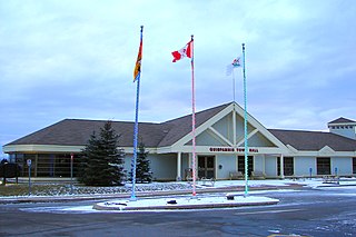
Quispamsis is a suburban town located in Kings County, New Brunswick, Canada. Located within Saint John's metropolitan area, it borders the town of Rothesay to form the Kennebecasis Valley and is located along the lower Kennebecasis River. As of 2021, the population of Quispamsis was 18,768.

The Gondola Point Ferry is a cable ferry in the Canadian province of New Brunswick. The ferry crosses the Kennebecasis River, linking Gondola Point in Quispamsis on the southern bank, to Reeds Point on the Kingston Peninsula. The ferry carries New Brunswick Route 119, connecting it to New Brunswick Route 845 on the Kingston Peninsula.

Sussex is a civil parish in Kings County, New Brunswick, Canada.
Norton is a civil parish in Kings County, New Brunswick, Canada.
Westfield is a civil parish in Kings County, New Brunswick, Canada.

Kingston is a civil parish in Kings County, New Brunswick, Canada.
The Grand Bay is a body of water at the confluence of the Wolastoq and Kennebecasis rivers in southern New Brunswick, Canada. The bay is approximately 19.7 km2 and spans across the boundary between Saint John and Kings counties.

