King's Highway 33, commonly referred to as Highway 33 or Loyalist Parkway, is a provincially maintained highway in the Canadian province of Ontario. The route begins in Trenton, Ontario and travels south to Prince Edward County and then continues east to the Collins Bay Road junction at Collins Bay in the city of Kingston, a distance of 60.9 kilometres (37.8 mi). The highway continues farther east into Kingston as Bath Road, ending at the former Highway 2, now Princess Street. Highway 33 is divided into two sections by the Bay of Quinte. The Glenora Ferry service crosses between the two sections just east of Picton, transporting vehicles and pedestrians for free throughout the year.

The Kennebecasis River is a tributary of the Saint John River in southern New Brunswick, Canada. The name Kennebecasis is thought to be derived from the Mi'kmaq "Kenepekachiachk", meaning "little long bay place." It runs for approximately 95 kilometres, draining an area in the Caledonia Highlands, an extension of the Appalachian Mountains, inland from the Bay of Fundy.

Route 235, commonly called the Cabot Highway branches off from Route 230 at Southern Bay. Both Route 230 and Route 235 head towards Bonavista, Route 230 crossing the Bonavista Peninsula at this point to service towns on the Trinity Bay side of the Peninsula whilst Route 235 stays on the Bonavista Bay side of the Peninsula, going all the way to Cape Bonavista.
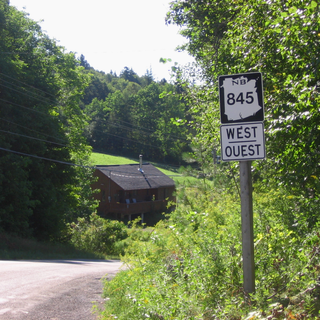
Route 845 is a Canadian highway in Kings County, New Brunswick.
Route 124 is an east/west provincial highway in the Canadian province of New Brunswick. The road runs from Route 1 exit 175 in Valley Waters as far as the Saint John River, where it crosses the Evandale Ferry to Evandale and an intersection with Route 102. The road has a length of approximately 41.3 kilometres, excluding the distance across the river, and services small, otherwise isolated rural communities. In these areas, the highway is often unofficially referred to as "Mountain Road."
Belleisle is an informal geographic region in the Canadian province of New Brunswick in the lower Saint John River valley.

Route 340, also known as Road to the Isles, is a road in the Canadian province of Newfoundland and Labrador passing through the towns of Lewisporte, Summerford and Twillingate, all in The Isles of Notre Dame region of the province.

Route 430 is a 413-kilometre-long (257 mi) paved highway that traverses the Great Northern Peninsula of Newfoundland in the Canadian province of Newfoundland and Labrador. The route begins at the intersection of Route 1 in Deer Lake and ends in St. Anthony. Officially known as the Great Northern Peninsula Highway, it has been designated as the Viking Trail since it is the main auto route to L'Anse aux Meadows, the only proven Viking era settlement in North America. It is the primary travel route in the Great Northern Peninsula and the only improved highway between Deer Lake and St. Anthony. It is the main access route to the Labrador Ferry terminal in St. Barbe.
Route 127 is an East/West provincial highway in the Canadian province of New Brunswick. The Highway starts out in Lawrence Station at the intersection of Route 3 The road travels mainly south for almost 60 km through mostly rural communities. The road does pass Rickets Island and runs along the Canada/US border as is the main route into St. Andrews where the road name changes to Bayview Drive and Mowat Drive. In St. Andrews the highway takes a sharp almost U-Turn before finally ending in the community of Bocabec.
Route 172 is a 16 km (9.9 mi)-long mostly north–south secondary highway in southwest New Brunswick, Canada.
Route 176 is a 10-kilometre (6.2 mi)-long mostly north–south secondary highway in southwest New Brunswick, Canada.
Route 345 is a 12-kilometre (7.5 mi) long east–west secondary riverfront highway in the north-east portion of New Brunswick, Canada.
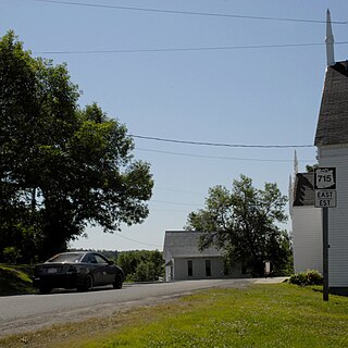
Route 715 is a 53.2-kilometre (33.1 mi) long local highway in Queens County, New Brunswick. Its western terminus is in Jemseg at Route 695 near its interchange with Route 2 and its eastern terminus is in Coles Island at Route 10 and Route 112. It is signed as an east–west highway although its westernmost portion along the Saint John River runs nearly due north and south.
Route 772 is a 20.1-kilometre-long (12.5 mi) mostly north–south secondary looping highway on Deer Island, Charlotte County, New Brunswick, Canada.
Route 790 is a 31.1-kilometre (19.3 mi) long mostly east–west secondary highway in the southwestern portion of New Brunswick, Canada.

Kingston is a civil parish in Kings County, New Brunswick, Canada.
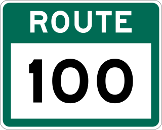
Route 100 is a major highway in Newfoundland and Labrador. The highway begins at its northern terminus at the Trans-Canada Highway in the town of Whitbourne, runs for 108 kilometres (67 mi) until it ends at its southern terminus, the town of Branch, where it transitions into Route 92. Motorists can drive along the coast of Placentia Bay once traveling south of Point Verde.

Route 70, also known as Roaches Line and Conception Bay Highway, is a 109-kilometre-long (68 mi) north-south highway on the Avalon Peninsula of Newfoundland. The highway also carries the designation of Baccalieu Trail for its entire length.

Route 331, also known as Boyd's Cove Highway, is a 27.4-kilometre-long (17.0 mi) east–west highway on the island of Newfoundland in the province of Newfoundland and Labrador. It connects the town of Boyd's Cove with the Gander Bay area of the island.
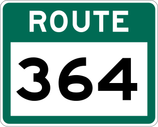
Route 364, also known as Hermitage River Road, is a 37.4-kilometre-long (23.2 mi) north–south highway on the Connaigre Peninsula of the island of Newfoundland. It connects the towns of Seal Cove and Hermitage-Sandyville with Route 360.

