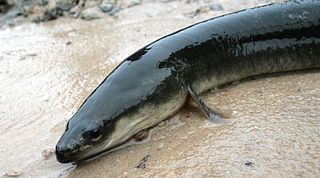
The American eel is a facultative catadromous fish found on the eastern coast of North America. Freshwater eels are fish belonging to the elopomorph superorder, a group of phylogenetically ancient teleosts. The American eel has a slender, supple, snake-like body that is covered with a mucus layer, which makes the eel appear to be naked and slimy despite the presence of minute scales. A long dorsal fin runs from the middle of the back and is continuous with a similar ventral fin. Pelvic fins are absent, and relatively small pectoral fins can be found near the midline, followed by the head and gill covers. Variations exist in coloration, from olive green, brown shading to greenish-yellow and light gray or white on the belly. Eels from clear water are often lighter than those from dark, tannic acid streams.

The Savannah River is a major river in the Southeastern United States, forming most of the border between South Carolina and Georgia. Two tributaries of the Savannah, the Tugaloo River and the Chattooga River, form the northernmost part of the state border. The Savannah River drainage basin extends into the southeastern side of the Appalachian Mountains just inside North Carolina, bounded by the Eastern Continental Divide. The river is around 301 miles (484 km) long. The Savannah was formed by the confluence of the Tugaloo River and the Seneca River. Today this confluence is part of Lake Hartwell. The Tallulah Gorge is located on the Tallulah River, a tributary of the Tugaloo River that forms the northwest branch of the Savannah River.

The Mullica River is a 50.6-mile-long (81.4 km) river in southern New Jersey in the United States. The Mullica was once known as the Little Egg Harbor River.

The Kennebecasis River is a tributary of the Saint John River in southern New Brunswick, Canada. The name Kennebecasis is thought to be derived from the Mi'kmaq "Kenepekachiachk", meaning "little long bay place." It runs for approximately 95 kilometres, draining an area in the Caledonia Highlands, an extension of the Appalachian Mountains, inland from the Bay of Fundy.
The Kingston Peninsula is a peninsula in southern New Brunswick, Canada, located between the Saint John River and the Kennebecasis River in Kings County.
Belleisle is an informal geographic region in the Canadian province of New Brunswick in the lower Saint John River valley.

Sydney Zoo is a zoo in Bungarribee in the Western Sydney Parklands, in Greater Western Sydney, New South Wales, Australia. Sydney Zoo is located 38 kilometres (24 mi) west of the Sydney central business district. It occupies a 16.5-hectare (41-acre) site. Sydney Zoo is a member of the Zoos and Aquariums Association of Australia and New Zealand.

Route 850 is a Canadian highway in Kings County, New Brunswick.
Springfield is a civil parish in Kings County, New Brunswick, Canada.

The life zones of West Virginia allow for a diversity of habitats for fauna, varying from large lowland farming valleys bordered with forest and meadow to highland ridge flats and heavy forestland, some with rocky ridge-line peaks. The "Mountain State" harbors at least 56 species and subspecies of mammals. The state has more than 300 types of birds and more than 100 species of fish.

The Department of Transportation and Infrastructure is a part of the Government of New Brunswick. It is charged with maintenance of government facilities and the province's highway network. From 1855 to 1912, it was known as the Board of Public Works. From 1912 to 1967, it was known as Department of Public Works and Highways. In 1967, its functions were divided between the Department of Public Works and the Department of Transportation. In 2012, the Department of Transportation and the infrastructure management components of the Department of Supply and Services were merged back together.
The Belleisle Bay Ferry is a cable ferry in the Canadian province of New Brunswick. The ferry crosses Belleisle Bay, a fjord-like branch of the Saint John River, linking Kars on the north bank to Long Point on the south bank.
The Gagetown Ferry is a cable ferry in the Canadian province of New Brunswick. The ferry crosses the Saint John River, linking Arcadia on the west bank with Lower Jemseg on the east bank.

The Medomak River, historically known as the Muscongus River, is a 40-mile-long (64 km) river in Maine. From its source in Liberty, the river winds 32 miles (51 km) south to the head of its tidal river estuary in Waldoboro, then about 8 miles (13 km) south to Bremen. The river flows through Hockomock Channel into the head of Muscongus Bay. Medomak is Abenaki for "place (river) of many alewives".
Belleisle or Belle Île may refer to:
Route 165 is a 22 km (14 mi)-long north–south secondary highway in the western New Brunswick, Canada.

Kingston is a civil parish in Kings County, New Brunswick, Canada.

