
New Brunswick Route 8 is a major highway in the province of New Brunswick, Canada. It is 261 kilometres (162 mi) long and connects Fredericton to the south with Miramichi and Bathurst to the north.
Route 16 is a two-lane highway in the Canadian province of New Brunswick. The 52 km (32 mi) route begins at a T intersection with Aulac Road at Aulac and ends at the midpoint of the Confederation Bridge, where it becomes Prince Edward Island Route 1.
Route 104 is a highway in New Brunswick, Canada, running from an intersection with the Trans-Canada Highway near Hartland to an intersection with Route 105 at Mouth of Keswick, a distance of 83 kilometres.

Route 106 is a highway in New Brunswick, Canada; running from an intersection with Route 1 and the western terminus of Route 905 in Three Rivers to the intersection of Trans-Canada Highway and the southern terminus of Route 940 in Sackville; a distance of 91.8 kilometres.
Route 107 is a highway in New Brunswick, Canada; running from an intersection with Route 8 at Nashwaak Bridge to an intersection with Route 105 at Bristol; a distance of 100.1 kilometres.
Route 108 is a highway in New Brunswick, Canada; running from Trans-Canada Highway exit 75 near Grand Falls to Route 8 exit 163 at Derby Junction ; a distance of 202.9 kilometres.
Route 112 is a highway in New Brunswick, Canada; running from Route 114 at the south end of the Petitcodiac River Causeway in Riverview, to an intersection with Route 10 at Coles Island. The route is 88.8 kilometres long.
Route 960 is a Canadian highway in Westmorland County, New Brunswick.
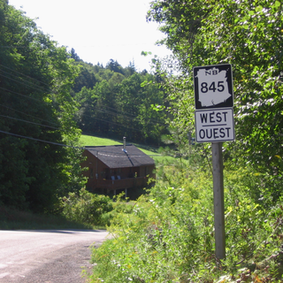
Route 845 is a Canadian highway in Kings County, New Brunswick.
Route 124 is an east/west provincial highway in the Canadian province of New Brunswick. The road runs from Route 1 exit 175 in Valley Waters as far as the Saint John River, where it crosses the Evandale Ferry to Evandale and an intersection with Route 102. The road has a length of approximately 41.3 kilometres, excluding the distance across the river, and services small, otherwise isolated rural communities. In these areas, the highway is often unofficially referred to as "Mountain Road."

Route 705 is a highway in New Brunswick, Canada that runs from an intersection of Route 124 in Kars to an intersection with Route 710 in Henderson Settlement, a distance of 31.3 kilometres. In 2009, the cable ferry service connecting Route 705 in Wickham to Route 102 in Hampstead was cancelled by the New Brunswick Department of Transportation.
Route 103 is a highway in New Brunswick, Canada, running from Woodstock to Florenceville along the west bank of the Saint John River, a distance of 42 kilometres.

Route 850 is a Canadian highway in Kings County, New Brunswick.
Route 303 is a short provincial route in New Brunswick, Canada that runs from Route 11 near Dugas to an intersection with Route 320 in Maisonnette.
Route 320 is a short provincial route in New Brunswick, Canada that runs from Route 11 in Grande-Anse to an intersection with Route 303 in Maisonnette.
Route 126 is a North/South provincial highway in the Canadian province of New Brunswick. The road runs from Route 117 intersection in Miramichi. The road has a length of approximately 121 kilometres, and services small, otherwise isolated rural communities. In these areas, the highway is often unofficially referred to as "Main Street." The road parallels the New Brunswick East Coast Railway directly to the east. When the highway enters Moncton it changes to Ensley Drive, then Mountain Road.
Route 117 is an East/West provincial highway in the Canadian province of New Brunswick. The road runs from Route 11 intersection in Saint-Louis. The road has a length of approximately 114 kilometres, and services small, otherwise isolated rural communities. In these areas, the highway is often unofficially referred to as "Main Street." The Road is called Loggie Road, Wellington Street, University Avenue, and Airport Road in the city of Miramichi. This Route Mainly follows the Gulf of St. Lawrence in New Brunswick.
Route 121 is a mostly north–south provincial highway in the Canadian province of New Brunswick, although it's signed as an east–west highway. The road runs from the Route 1 intersection in Hampton. The road is approximately 40 kilometres, and services small, otherwise isolated, rural communities. In these areas, the highway is often unofficially referred to as "Main Street." The road parallels Route 1 and follows the Kennebecasis River. The highway starts in Hampton as Hall Road, then Main Street. It is also called Main Street in Sussex.
Route 122 is a mostly East/West provincial highway in the Canadian province of New Brunswick. The road runs from Route 2 and Route 165 intersection in Dow Settlement. The road has a length of approximately 44 kilometres, and services small, otherwise isolated rural communities. In these areas, the highway is often unofficially referred to as "Main Street." The road bypasses several Lakes including Skiff Lake, Mud Lake, Eel River Lake, North Lake and finally Grand Lake before changing to Boundary Road in Orient, Maine at the Canada–United States border. The Highway is known as Canterbury Road within Lakeland Ridges.
Route 127 is an East/West provincial highway in the Canadian province of New Brunswick. The Highway starts out in Lawrence Station at the intersection of Route 3 The road travels mainly south for almost 60 km through mostly rural communities. The road does pass Rickets Island and runs along the Canada/US border as is the main route into St. Andrews where the road name changes to Bayview Drive and Mowat Drive. In St. Andrews the highway takes a sharp almost U-Turn before finally ending in the community of Bocabec.
