
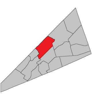
Hatfield Point
Location of Hatfield Point in New Brunswick
Hatfield Point is a settlement on the Belleisle Bay in Kings County, New Brunswick.
Hatfield Point is a settlement on the Belleisle Bay in Kings County, New Brunswick.

Hatfield Point is located at the head of the Belleisle Bay, called "Pascobac" ("Side Bay") by the Maliseet, who hunted and fished in the area. European settlement began in 1783 with the arrival of Captain Thomas Spragg, a United Empire Loyalist militia officer from Hempstead, Long Island. [1] Spragg and his adult sons were granted large tracts on the north side of the Bay, soon dubbed "Spragg's Point".
The first settlers were largely Loyalists from New York, with subsequent immigration directly from Britain and Ireland. Originally, most belonged to the established Church of England. However, the early 1800s brought a religious shift as the Anglican Church moved to Springfield. Founded in 1806, the "First Springfield Calvinist Baptist Church", now "Hatfield Point Baptist Church", became the mother church of several Baptist chapels around the Belleisle.
The economy was mainly agricultural, supplemented by seasonal trade in lumber and fur. The early-to-mid 1800s saw the rise of riverboats on the Saint John River system, which became the chief means of transportation in southern New Brunswick. Spragg's Point was the last stop on the Belleisle, and the Pleasantview Hotel opened to house the incoming travellers and salesmen. In the 1880s, the settlement became Hatfield's Point, reflecting the preference of the local postmaster. In addition to the hotel and the post office, Hatfield Point would also host a sawmill, a doctor's office, two stores, a Pentecostal Church and later an auto garage. The boiler of the SS Springfield, a riverboat that burnt down while at anchor off the point, is still visible from the community wharf, emerging from the water in a shallow part of the bay.
Though a very small community, Hatfield Point and its people have been the subjects of several oral and informal histories, including works by Marsha Boyd, Thomas Shanklin, Calin Coburn and Elizabeth Drake McDonald. Though these deal with particular families and events, they combine to give a fuller impression of life in the Belleisle Valley.
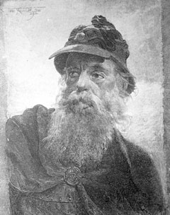
Hatfield Point's most famous resident was Bob Nolan, born Robert Clarence Nobles. He spent much of his childhood on his grandparents' farm in Hatfield Point. He was a member of the Sons of the Pioneers and a prolific songwriter, with Cool Water and Tumbling Tumbleweeds his best-known works.
David Crandall, the son of Joseph Crandall, was the resident Baptist minister for a period in the late 1800s. Hatfield Point was also the birthplace and summer residence of Prof. Shirley Jackson Case. Born in 1872, Case was a mathematician and church historian at the University of Chicago.

New Brunswick is one of the thirteen provinces and territories of Canada. It is one of the three Maritime provinces and one of the four Atlantic provinces. It is the only province with both English and French as its official languages.

Saint John is a seaport city of the Atlantic Ocean located on the Bay of Fundy in the province of New Brunswick, Canada. Saint John is the oldest incorporated city in Canada, established by royal charter on May 18, 1785, during the reign of King George III. The port is Canada's third-largest port by tonnage with a cargo base that includes dry and liquid bulk, break bulk, containers, and cruise. The city was the most populous in New Brunswick until the 2016 census, when it was overtaken by Moncton. It is currently the second-largest city in the province, with a population of 69,895 over an area of 315.59 km2 (121.85 sq mi).

Bathurst is the largest City in Northern New Brunswick with a population of 12,157 and the 4th largest metropolitan Area in New Brunswick as defined by Census Canada with a population of 31,387 as of 2021. The City of Bathurst overlooks Nepisiguit Bay, part of Chaleur Bay and is at the estuary of the Nepisiguit River.

Brunswick is a town in Cumberland County, Maine, United States. The population was 21,756 at the 2020 United States Census. Part of the Portland-South Portland-Biddeford metropolitan area, Brunswick is home to Bowdoin College, the Bowdoin International Music Festival, the Bowdoin College Museum of Art, the Peary–MacMillan Arctic Museum, and the Maine State Music Theatre. It was formerly home to the U.S. Naval Air Station Brunswick, which was permanently closed on May 31, 2011, and has since been partially released to redevelopment as "Brunswick Landing".

St. Stephen is a Canadian town in Charlotte County, New Brunswick, situated on the east bank of the St. Croix River around the intersection of New Brunswick Route 170 and the southern terminus of New Brunswick Route 3. The St. Croix River marks a section of the Canada–United States border, forming a natural border between Calais, Maine and St. Stephen. U.S. Route 1 parallels the St. Croix river for a few miles, and is accessed from St. Stephen by three cross-border bridges.

The Saint John River is a 673 kilometres (418 mi) long river that flows from Northern Maine into Canada, and runs south along the western side of New Brunswick, emptying into the Atlantic Ocean in the Bay of Fundy. Eastern Canada's longest river, its drainage basin is one of the largest on the east coast at about 55,000 square kilometres (21,000 sq mi).

Memramcook, sometimes also spelled Memramcouke or Memramkouke, is a village in Westmorland County, New Brunswick, Canada. Located in south-eastern New Brunswick, the community is predominantly people of Acadian descent who speak the Chiac derivative of the French language. An agricultural village, it has a strong local patrimony, key to the history of the region. It was home to Mi'kmaqs for many years and was the arrival site of Acadians in 1700. A large part of these Acadians were deported in 1755, but the village itself survived.

The Diocese of Nova Scotia and Prince Edward Island is a diocese of the Ecclesiastical Province of Canada of the Anglican Church of Canada. It encompasses the provinces of Nova Scotia and Prince Edward Island and has two cathedrals: All Saints' in Halifax and St. Peter's in Charlottetown. Its de facto see city is Halifax, and its roughly 24 400 Anglicans distributed in 239 congregations are served by approximately 153 clergy and 330 lay readers according to the last available data. According to the 2001 census, 120,315 Nova Scotians identified themselves as Anglicans, while 6525 Prince Edward Islanders did the same.

Grand Bay-Westfield is a town on the west bank of the Saint John River immediately north of the boundary between Kings County and Saint John County.

Jemseg is a Canadian rural community in Cambridge Parish, Queens County, New Brunswick. It is located on the east bank of the Jemseg River along its short run from Grand Lake to the Saint John River. The village briefly served as the Capital of Acadia (1690–91).

Black Nova Scotians are Black Canadians whose ancestors primarily date back to the Colonial United States as slaves or freemen, later arriving in Nova Scotia, Canada, during the 18th and early 19th centuries. As of the 2021 Census of Canada, 28,220 Black people live in Nova Scotia, most in Halifax. Since the 1950s, numerous Black Nova Scotians have migrated to Toronto for its larger range of opportunities. Before the immigration reforms of 1967, Black Nova Scotians formed 37% of the total Black Canadian population.
Elijah Miles was a merchant, farmer, land owner and political figure in New Brunswick. He represented Sunbury County in the Legislative Assembly of New Brunswick from 1803 to 1809 and from 1816 to 1827.
Springfield is a civil parish in Kings County, New Brunswick, Canada.

Higher education in New Brunswick refers to education provided by higher education institutions in the Canadian province of New Brunswick. Higher education has a rich history in New Brunswick. The first English-language university in Canada was the University of New Brunswick. Mount Allison University was the first in the British Empire to award a baccalaureate to a woman, Grace Annie Lockhart, B.Sc. in 1875. Education is the responsibility of the provinces in Canada and there is no federal ministry governing it.

The Brattle Street Church (1698–1876) was a Congregational and Unitarian church on Brattle Street in Boston, Massachusetts.
The Battle of Falmouth involved Joseph-François Hertel de la Fresnière and Baron de St Castin leading troops as well as the Wabanaki Confederacy in New Brunswick to capture and destroy Fort Loyal and the English settlement on the Falmouth neck, then part of the Massachusetts Bay Colony. The commander of the fort was Captain Sylvanus Davis. After two days of siege, the settlement's fort, called Fort Loyal, surrendered. The community's buildings were burned, including the wooden stockade fort, and its people were either killed or taken prisoner. The fall of Fort Loyal (Casco) led to the near depopulation of Europeans in Maine. Native forces were then able to attack the New Hampshire frontier without reprisal.

The history of Saint John, New Brunswick is one that extends back thousands of years, with the area being inhabited by the Maliseet and Miꞌkmaq First Nations prior to the arrival of European colonists. During the 17th century, a French settlement was established in Saint John. During the Acadian Civil War, Saint John served as the seat for the administration under Charles de Saint-Étienne de la Tour. The French position in Saint John was abandoned in 1755, with British forces having taken over the area shortly afterwards.
The Province of Nova Scotia was heavily involved in the American Revolutionary War (1776–1783). At that time, Nova Scotia also included present-day New Brunswick until that colony was created in 1784. The Revolution had a significant impact on shaping Nova Scotia, "almost the 14th American Colony". At the beginning, there was ambivalence in Nova Scotia over whether the colony should join the Americans in the war against Britain. Largely as a result of American privateer raids on Nova Scotia villages, as the war continued, the population of Nova Scotia solidified their support for the British. Nova Scotians were also influenced to remain loyal to Britain by the presence of British military units, judicial prosecution by the Nova Scotia Governors and the efforts of Reverend Henry Alline.
Marsha L. Boyd [1] Marsha L. Boyd [2] Gordon Pradl [3] Thomas L. Shanklin [4] Calin Coburn & Elizabeth Drake McDonald,. [5]