New Brunswick Route 145

Last updated

NB 145.svg

Route 145
Route information
Maintained by New Brunswick Department of Transportation
Length 15.9 km [1] (9.9 mi)
Existed 1984 – present
Major junctions
East end Ch. Mysterieux in Pokesudie [ citation needed ]
 NB 335.svg Route 335 in Le Bouthillier
West endNB 11.svg Route 11 in Bertrand [ citation needed ]
Location
Major cities Caraquet, Bas-Caraquet
Highway system

Provincial highways in New Brunswick
Former routes

NB 144.svg Route 144 Route 148 NB 148.svg

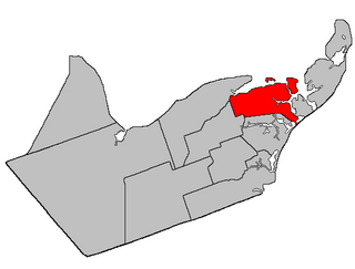
Route 145 is a 26.7 km (16.6 mi)-long north-south secondary highway in northeast New Brunswick, Canada.

New Brunswick province in Canada

New Brunswick is one of four Atlantic provinces on the east coast of Canada. According to the Constitution of Canada, New Brunswick is the only bilingual province. About two thirds of the population declare themselves anglophones and a third francophones. One third of the population describes themselves as bilingual. Atypically for Canada, only about half of the population lives in urban areas, mostly in Greater Moncton, Greater Saint John and the capital Fredericton.

Canada Country in North America

Canada is a country in the northern part of North America. Its ten provinces and three territories extend from the Atlantic to the Pacific and northward into the Arctic Ocean, covering 9.98 million square kilometres, making it the world's second-largest country by total area. Canada's southern border with the United States, stretching some 8,891 kilometres (5,525 mi), is the world's longest bi-national land border. Its capital is Ottawa, and its three largest metropolitan areas are Toronto, Montreal, and Vancouver. As a whole, Canada is sparsely populated, the majority of its land area being dominated by forest and tundra. Consequently, its population is highly urbanized, with over 80 percent of its inhabitants concentrated in large and medium-sized cities, with 70% of citizens residing within 100 kilometres (62 mi) of the southern border. Canada's climate varies widely across its vast area, ranging from arctic weather in the north, to hot summers in the southern regions, with four distinct seasons.

Contents

The routes western terminus is at Route 325 in Bertrand, New Brunswick [ citation needed ]. From there, it runs east along Caraquet Bay and Chaleur Bay through the town of Caraquet following the previous alignment of Route 11 before crossing onto Pokesudie Island.

Route 325 is a 9-kilometre (5.6 mi) long north–south secondary highway in the southwest portion of New Brunswick, Canada.

Bertrand, New Brunswick Village in New Brunswick, Canada

Bertrand is a Canadian village in Gloucester County, New Brunswick.

History

Route 145 was commissioned in 1984 as a renumbering of the former Route 330, which had existed since 1965. October 2016 the route was extended continuing where the former Route 11 used to be.

Route 330 is a 10-kilometre (6.2 mi) long, north/south secondary highway in the southwest portion of New Brunswick, Canada.

New Brunswick Route 11 highway in New Brunswick

Route 11 is a provincial highway in northeastern New Brunswick, Canada. The 435 km road runs from Shediac to the Quebec border, near Campbellton, at the Interprovinciale Bridge, following the province's eastern and northern coastlines.

Communities

Caraquet Town in New Brunswick, Canada

Caraquet is a town in Gloucester County, New Brunswick, Canada.

Bas-Caraquet, New Brunswick Village in New Brunswick, Canada

Bas-Caraquet is a Canadian village in Gloucester County, New Brunswick.

Pokesudie is a community in the Canadian province of Gloucester County, New Brunswick.

See also

Related Research Articles

Beresford, New Brunswick Town in New Brunswick, Canada

Beresford is a Canadian town in Gloucester County, New Brunswick.

Maisonnette, New Brunswick Village in New Brunswick, Canada

Maisonnette is a village in Gloucester County, New Brunswick, Canada.

Route 177 is a provincial highway in the southwestern portion of the Canadian province of New Brunswick. Its main purpose is to serve the town of Grand Bay-Westfield. Route 177 is a former alignment of Route 7 and is 19.6 kilometres long.

Janeville, New Brunswick Place in New Brunswick, Canada

Janeville is a community in Gloucester County, New Brunswick on the Chaleur Bay. The Community is located at the Intersection of Route 11 and Route 340.

Department of Transportation and Infrastructure (New Brunswick) government ministry in New Brunswick

The Department of Transportation and Infrastructure is a part of the Government of New Brunswick. It is charged with maintenance of government facilities and the province's highway network. From 1855 to 1912, it was known as the Board of Public Works. From 1912 to 1967, it was known as Department of Public Works and Highways. In 1967, its functions were divided between the Department of Public Works and the Department of Transportation. In 2012, the Department of Transportation and the infrastructure management components of the Department of Supply and Services were merged back together.

Caraquet Bay

Caraquet Bay is situated in the northeast of the Canadian province of New Brunswick. It is bordered on the south by the town of Caraquet and the village of Bertrand, to the south by the parish of New Bandon, to the north by the village of Maisonnette and to the northwest by the Baie des Chaleurs. Caraquet Island is located between the two bays. There are a number of beaches on the bay, as well as oyster farms and the port of Caraquet. Caraquet Bay flows into the Caraquet River and the Du Nord River

Route 134 is a 261 km (162 mi)-long north-south secondary highway in eastern New Brunswick, Canada. The highway is divided by into a northern and southern section by a gap in Northumberland County connected by Route 11 and Route 8.

New Bandon Parish, New Brunswick Parish in New Brunswick, Canada

New Bandon Parish is a Canadian parish in Gloucester County, New Brunswick. It was named after the town of Bandon in Ireland. Within the parish is the rural community of New Bandon, which lies between Pokeshaw on the east, and Stonehaven on the west.

Caraquet Parish, New Brunswick Parish in New Brunswick, Canada

Caraquet is a Canadian parish in Gloucester County, New Brunswick.

Shippegan Parish, New Brunswick Parish in New Brunswick, Canada

Shippegan is a Canadian parish in Gloucester County, New Brunswick.

Route 117 is an East/West provincial highway in the Canadian province of New Brunswick. The road runs from Route 11 intersection in Saint-Louis. The road has a length of approximately 114 kilometers, and services small, otherwise isolated rural communities. In these areas, the highway is often unofficially referred to as "Main Street." The Road is called Loggie Road, Wellington Street, University Avenue, and Airport Road in the city of Miramichi. This Route Mainly follows the Gulf of St Lawrence in New Brunswick.

Route 170 is an 18 km (11 mi)-long east-west secondary highway in southwest New Brunswick, Canada.

Route 335 or Saint-Simon Road is a 13-kilometre (8.1 mi) long, north/south secondary highway in the southeastern portion of New Brunswick, Canada.

The Caraquet River is a river in north-eastern New Brunswick, Canada which empties into the Caraquet Bay north of Caraquet.

References

  1. New Brunswick Department of Transportation: Designated Provincial Highways, 2003