The Trans-Canada Highway is a transcontinental federal–provincial highway system that travels through all ten provinces of Canada, from the Pacific Ocean on the west coast to the Atlantic Ocean on the east coast. The main route spans 7,476 km (4,645 mi) across the country, one of the longest routes of its type in the world. The highway system is recognizable by its distinctive white-on-green maple leaf route markers, although there are small variations in the markers in some provinces.
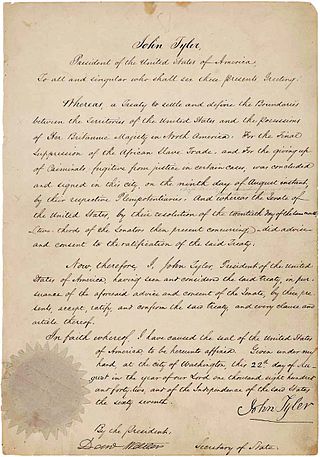
The Webster–Ashburton Treaty, signed August 9, 1842, was a treaty that resolved several border issues between the United States and the British North American colonies. Negotiated in the US federal capital city of Washington, DC, it was signed August 9, 1842, under the new administration of US President John Tyler, who as the former vice president, had just recently succeeded and became chief executive upon the unexpected death of his running mate and predecessor, William Henry Harrison, who had only served a single month in office. The Daniel Webster–Lord Ashburton negotiations and new drawn-up 1842 treaty resolved many of the issues of the recent border conflicts and skirmishes between Americans and New Brunswickers in the Aroostook War of 1838–1839. It arose from disputes and controversies over the vague indefinite terms and text of the old peace agreement of the Treaty of Paris of 1783, which ended the American Revolutionary War.

The Yellowhead Highway is a major interprovincial highway in Western Canada that runs from Winnipeg to Graham Island off the coast of British Columbia via Saskatoon and Edmonton. It stretches across the four western Canadian provinces of British Columbia, Alberta, Saskatchewan, and Manitoba and is part of the Trans-Canada Highway system and the larger National Highway System, but should not be confused with the more southerly, originally-designated Trans-Canada Highway. The highway was officially opened in 1970. Beginning in 1990, the green and white Trans-Canada logo is used to designate the roadway.
Route 1 is a highway in the southern part of the Canadian province of New Brunswick. It begins west of the Canada–United States border at St. Stephen, and runs east for 239.11 kilometres (148.58 mi) to Route 2 at River Glade.

New Brunswick Route 8 is a major highway in the province of New Brunswick, Canada. It is 261 kilometres (162 mi) long and connects Fredericton to the south with Miramichi and Bathurst to the north.
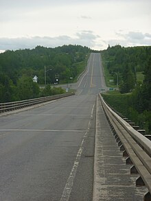
Route 2 is a major provincial highway in the Canadian province of New Brunswick, carrying the main route of the Trans-Canada Highway in the province. The highway connects with Autoroute 85 at the border with Quebec, Highway 104 at the border with Nova Scotia, as well as with traffic from Interstate 95 in the U.S. state of Maine via the short Route 95 connector. A core route in the National Highway System, Route 2 is a four-lane freeway in its entirety, and directly serves the cities of Edmundston, Fredericton, and Moncton.

King's Highway 2, commonly referred to as Highway 2, is the lowest-numbered provincially maintained highway in the Canadian province of Ontario, and was originally part of a series of identically numbered highways which started in Windsor, stretched through Quebec and New Brunswick, and ended in Halifax, Nova Scotia. Prior to the 1990s, Highway 2 travelled through many of the major cities in Southern Ontario, including Windsor, Chatham, London, Brantford, Hamilton, Burlington, Mississauga, Toronto, Oshawa, Belleville, Kingston and Cornwall, and many other smaller towns and communities.
King's Highway 48, also known as Highway 48, is a provincially maintained highway in southern Ontario that extends from Major Mackenzie Drive in Markham, through Whitchurch-Stouffville and East Gwillimbury, to Highway 12 south-east of Beaverton. The route is generally rural and straight, passing near several communities within the Regional Municipality of York. The route is 65.2 kilometres (40.5 mi) long. Most part of the road has a speed limit of 80 km/h (50 mph), except within town limits, where the speed limit is reduced to 60 km/h (37 mph) or 50 km/h (31 mph).
King's Highway 12, commonly referred to as Highway 12 and historically known as the Whitby and Sturgeon Bay Road, is a provincially maintained highway in the Canadian province of Ontario. The highway connects the eastern end of the Greater Toronto Area (GTA) with Kawartha Lakes, Orillia and Midland before ending at Highway 93. It forms the Central Ontario Route of the Trans-Canada Highway system from north of Sunderland to Coldwater. Highway 12 connects several small towns along its 146 km (91 mi) route, and bypasses a short distance from many others. It is signed as a north–south route between Whitby and Orillia, and as an east–west route from there to Midland. The rural portions of the highway feature a posted speed limit of 80 km/h (50 mph), often dropping to 50 km/h (31 mph) through built-up areas. The entire route is patrolled by the Ontario Provincial Police.
Route 108 is a highway in New Brunswick, Canada; running from Trans-Canada Highway exit 75 near Grand Falls to Route 8 exit 163 at Derby Junction ; a distance of 202.9 kilometres.

U.S. Route 1 (US 1) in the U.S. state of Maine is a major north–south section of the United States Numbered Highway System, serving the eastern part of the state. It parallels the Atlantic Ocean from New Hampshire north through Portland, Brunswick, and Belfast to Calais, and then the St. Croix River and the rest of the Canada–United States border via Houlton to Fort Kent. The portion along the ocean, known as the Coastal Route, provides a scenic alternate to Interstate 95 (I-95).
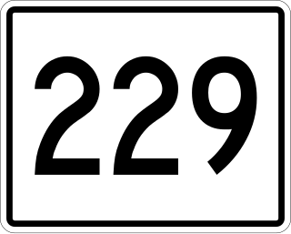
State Route 229 (SR 229) is a state highway located entirely within the town of Limestone in extreme northeastern Maine. It begins at U.S. Route 1A downtown and runs 1.94 miles (3.12 km) east to the Canada–US border, where it connects to New Brunswick Route 375. SR 229 is also known as Grand Falls Road.

Balmoral is a geographic parish in Restigouche County, New Brunswick, Canada.

Grand Falls is a geographic parish in Victoria County, New Brunswick, Canada; the legal name in French is Grand-Sault, the only parish with different legal English and French names.
Wakefield is a geographic parish in Carleton County, New Brunswick, Canada, located north on the west bank of the Saint John River north of Woodstock.
King's Highway 121, commonly referred to as Highway 121, was a provincially maintained highway in the Canadian province of Ontario that connected several communities in the cottage country region of Central Ontario on the southern edge of the Canadian Shield. Between Fenelon Falls and Minden, Highway 121 served as an alternative route to Highway 35, which was severely congested during summer weekends. From Minden, the highway branched east to Haliburton Village and thereafter followed the present route of Highway 118 to Highway 28 in Paudash.
Route 375 is a 5.4-kilometre (3.4 mi) long east–west secondary highway in the northwest portion of New Brunswick, Canada.
Route 560 is a 41.7-kilometre (25.9 mi) long north–south secondary highway in the western portion of New Brunswick, Canada.
Route 590 is an 11-kilometre (6.8 mi) long north–south secondary highway in the eastern portion of New Brunswick, Canada.
Grand Falls Portage is a settlement in Victoria County, New Brunswick, Canada. Grand Falls Portage is located 3.9 kilometres (2.4 mi) south Grand Falls at the intersection of Route 2 and Route 130.