Drummond, New Brunswick

Last updated

Drummond
Drummond NB.JPG
Canada New Brunswick location map 2.svg
Red pog.svg
Drummond
Location within New Brunswick
Coordinates: 47°02′07″N67°41′07″W / 47.0353°N 67.6852°W / 47.0353; -67.6852
CountryCanada
Province New Brunswick
County Victoria
Parish Drummond Parish
Town Grand Falls
Area
[1]
  Land8.88 km2 (3.43 sq mi)
Population
 (2021) [1]
  Total729
  Density82.1/km2 (213/sq mi)
  Change 2016–21
Decrease2.svg 1.1%
Time zone UTC-4 (Atlantic)
  Summer (DST) UTC-3 (Atlantic)
Area code Area code 506
Dwellings350
Website www.drummondnb.com

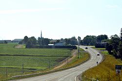
Drummond is a former village in northwestern New Brunswick, Canada. It held village status prior to 2023 and is now part of the town of Grand Falls.

Contents

It is located in rolling farmland approximately 5 kilometres southeast of Grand Falls, of which it is administratively a part. Drummond's economy is centred on the potato industry, and cereal crops such as wheat, barley and oats are grown mainly through crop rotation. More than 50% of the potatoes grown are sold for processing to McCain Foods Limited, and 45% are grown as seed potatoes for inter-provincial and international export.

History

The village was first settled by Irish immigrants in the 1850s. It was named after Gordon Drummond, a major in the British Army. Acadian settlement occurred during the latter half of the 19th century.

On 1 January 2023, Drummond amalgamated with the town of Grand Falls [2] The community's name remains in official use. [3]

Demographics

In the 2021 Census of Population conducted by Statistics Canada, Drummond had a population of 729 living in 335 of its 350 total private dwellings, a change of

Historical Census Data - Drummond, New Brunswick
YearPop.±%
2006 839    
2011 775−7.6%
2016 737−4.9%
2021 729−1.1%
Source: [4] [5] [1]

Notable people

See also

Related Research Articles

<span class="mw-page-title-main">Centreville, New Brunswick</span> Place in New Brunswick, Canada

Centreville is a former village in Carleton County, New Brunswick, Canada. It held village status prior to 2023 and is now part of the town of Carleton North.

<span class="mw-page-title-main">Gagetown, New Brunswick</span> Place in New Brunswick, Canada

Gagetown is a former village in Queens County, New Brunswick, Canada. It held village status prior to 2023 and is now part of the village of Arcadia. It is on the west bank of the Saint John River and is the county's shire town.

<span class="mw-page-title-main">Grand Falls, New Brunswick</span> Town in New Brunswick, Canada

Grand Falls is a town in northwestern New Brunswick, Canada, on the Saint John River. Its name comes from a waterfall created by a series of rock ledges over which the river drops 23 metres (75 ft).

<span class="mw-page-title-main">Beaubassin East, New Brunswick</span> Place in New Brunswick, Canada

Beaubassin East was an incorporated rural community in Westmorland County, New Brunswick, Canada. It held rural community status prior to 2023 and is now part of the town of Cap-Acadie.

<span class="mw-page-title-main">Saint-Quentin, New Brunswick</span> Town in New Brunswick, Canada

Saint-Quentin is a town in northern New Brunswick, Canada.

<span class="mw-page-title-main">Petit-Rocher, New Brunswick</span> Community in New Brunswick, Canada

Petit-Rocher is a former village in Gloucester County, New Brunswick. It held village status prior to 2023 and is now part of the town of Belle-Baie. Sitting on the western shore of both Chaleur Bay and Nepisiguit Bay 20 km northwest of Bathurst.

Blacks Harbour is a community in the rural community of Eastern Charlotte, New Brunswick, Canada. It held village status prior to 2023. It is on a harbour of the same name opening onto the Bay of Fundy. It is 15 kilometres southeast of the town of St. George, 3 kilometres west of Beaver Harbour and 56 kilometres east from the town of St. Stephen on Route 176.

<span class="mw-page-title-main">Saint-Antoine, New Brunswick</span> Place in New Brunswick, Canada

Saint-Antoine is a former village in Kent County, New Brunswick, Canada. It is 35 km north of Moncton and 18 km Southwest of Bouctouche. Saint-Antoine is on Route 115 and Route 525. It is now part of the town of Champdoré.

<span class="mw-page-title-main">Blackville, New Brunswick</span> Place in New Brunswick, Canada

Blackville is a former village in Northumberland County, New Brunswick, Canada. It is now part of the rural community of Miramichi River Valley.

Balmoral is a former village in Restigouche County, New Brunswick, Canada. It held village status prior to 2023 and is now part of the village of Bois-Joli. It is approximately 10 kilometres south of Dalhousie. Balmoral also contains the neighbourhoods of Blair Athol, Saint-Maure, Selwood, and Upper Balmoral.

<span class="mw-page-title-main">Charlo, New Brunswick</span> Community in New Brunswick

Charlo is a community and former village located in Heron Bay, New Brunswick, Canada. It held village status within Restigouche County prior to 2023.

Millville is a former village in York County, New Brunswick, Canada. It held village status prior to 2023 and is now part of the rural community of Nackawic-Millville. It is at the intersection of Route 104 and Route 605.

<span class="mw-page-title-main">Paquetville</span> Place in New Brunswick, Canada

Paquetville is a former village in Gloucester County, New Brunswick, Canada. It held village status prior to 2023 and is now part of the town of Hautes-Terres. It is on the Acadian Peninsula at the intersection of Route 340, Route 135 and Route 350.

Pointe-Verte is a community and former village in Gloucester County, New Brunswick. It held village status prior to 2023 and is now part of the Town of Belle-Baie.

<span class="mw-page-title-main">Saint-André, New Brunswick</span> Place in New Brunswick, Canada

Saint-André is community in Saint-André Parish, Madawaska County, New Brunswick, Canada. It was part of an eponymous rural community prior to 2023; the most recent census data is for the rural community. It is now part of the town of Grand Falls.

<span class="mw-page-title-main">Stanley, New Brunswick</span> Place in New Brunswick, Canada

Stanley is a former village in York County, in the Canadian province of New Brunswick; it was an incorporated village until the end of 2022 and is now part of the rural community of Nashwaak.

<span class="mw-page-title-main">Saint-Léonard, New Brunswick</span> Place in New Brunswick, Canada

Saint-Léonard is a former town in Madawaska County, New Brunswick, Canada. It held town status prior to 2023 and is now part of the town of Vallée-des-Rivières.

<span class="mw-page-title-main">Rivière-Verte, New Brunswick</span> Neighbourhood in Madawaska, New Brunswick, Canada

Rivière-Verte is a neighbourhood in Edmundston. It held village status prior to 2023.

<span class="mw-page-title-main">Lac Baker, New Brunswick</span> Place in New Brunswick, Canada

Lac Baker is a Canadian community in Madawaska County, New Brunswick, formerly an incorporated village but now part of the town of Haut-Madawaska.

<span class="mw-page-title-main">Lucky Lake</span> Village in Saskatchewan, Canada

Lucky Lake is a village in the Canadian province of Saskatchewan within the Rural Municipality of Canaan No. 225 and Census Division No. 7. The Village is located at the junction of Highway 42, Highway 45 and Highway 646 approximately 90 km northeast of Swift Current, Saskatchewan.

References

  1. 1 2 3 4 "Census Profile of Drummond". Statistics Canada. 6 December 2022. Retrieved 15 January 2023.
  2. "Local Governments Establishment Regulation – Local Governance Act". Government of New Brunswick. 12 October 2022. Retrieved 11 January 2023.
  3. "Proposed entity names reflect strong ties to nature and history" (Press release). Irishtown, New Brunswick: Government of New Brunswick. 25 May 2022. Retrieved 20 January 2023.
  4. "2011 Census Profile: Drummond, New Brunswick". Statistics Canada. Retrieved October 1, 2019.
  5. "Census Profile, 2016 Census: Drummond, Village [Census subdivision], New Brunswick". Statistics Canada. Retrieved October 1, 2019.