Shippagan

Last updated

Shippagan
Town
MarinadeShippagan2.jpg
The Marina in Shippagan
Canada New Brunswick location map 2.svg
Red pog.svg
Shippagan
Location within New Brunswick.
Coordinates: 47°44′38″N64°43′04″W / 47.743889°N 64.717778°W / 47.743889; -64.717778
CountryCanada
Province New Brunswick
County Gloucester
Parish Shippegan
Founded1790
Government
  TypeTown Council
  MayorKassim Doumbia [1]
Area
[2]
  Land9.96 km2 (3.85 sq mi)
Population
 (2021) [2]
  Total2,672
  Density268.3/km2 (695/sq mi)
  Change (2016–21)
Increase2.svg 3.6%
  Dwellings
1,274
Time zone UTC-4 (AST)
  Summer (DST) UTC-3 (ADT)
Postal code(s)
E8S
Area code 506
Website www.shippagan.ca

Shippagan is a Canadian town within [lower-alpha 1] Shippegan Parish, Gloucester County, New Brunswick.

Contents

The parish retains the original English spelling, while the town officially adopted the colloquial French spelling on 1 July 1981. [4]

Shippagan was greatly enlarged on 1 January 2023, when it amalgamated with Le Goulet and all or part of seven local service districts [5] [6] Revised census figures have not been released.

Geography

Shippagan is located in the northeastern part of the Acadian Peninsula: a combination bridge-causeway connects the town with Lamèque Island to the northeast.

The peninsula is approximately 5 km (3 miles) long and at maximum 5 km (3 miles) wide, bordered on the north-west by Shippagan Bay, to the north by Shippagan harbour to the east by the Gulf of Saint Lawrence and to the west by St Simon's Bay.

Approximately 99% of the town's residents are Francophone.

History

The town was founded by Jean Mallet (son of Francois Mallet and Marie Madeleine Larocque) and Marie Josephte Duguay (daughter of Rene Duguay and Marguerite LeBreton) from Paspébiac, Quebec and the Robichaux family from Bonaventure, Quebec in 1790, as a result of expansion of the Charles Robin Company. Jean-Baptiste Robichaux was in 1798 the first settler from Grand Chipagan to petition the government for title to his land, in 1798; he was the son of an expelled Acadian. [7]

The location of the town is an ideal spot for fishing, which was its first economic product, as well as exporting timber from further inland. There are also numerous peat bogs in the area, and their exploitation continues to this day.

Shippagan is home to campuses of the Université de Moncton and New Brunswick Community College.

On May 25, 2021, [8] Shippagan elected Kassim Doumbia as mayor, making him the first Black mayor in New Brunswick. [1]

Etymology

The name originates from the Mi'kmaq Sepagun-chiche, which roughly translates as "Ducks' transit route". This name described the immediate region rather than the specific location of the current settlement that inherited the name.

Different spellings have been applied over the years. None of the earliest known francophone explorers such as Jacques Cartier, Samuel de Champlain and Nicolas Denys mentions the name Shippagan, which appears in writing for the first time only in 1656 when Ignatius of Paris, a Capucine missionary, wrote to his superiors recommending the establishment of four or five missionary posts, one of which he called "Cibaguensi", a Latinised form of Shippagan.

During the eighteenth century various orthographies were used for the nearby settlement on the site of what is now Bas-Caraquet, [9] most commonly Chipagan, and this is the name subsequently applied and adapted for modern-day Shippagan. Early English language texts applied the francophone spelling, "Chipagan", but from the early nineteenth centuries various anglophone variants were preferred, such as Shipagan, Ship-a-gang, Shipegan, Shippegan, Shippigan and Shippagan. [10] By the twenty-first century custom had settled on "Town of Shippagan" which on September 9, 2009, was officially reduced to "Shippagan". [11]

Demographics

In the 2021 Census of Population conducted by Statistics Canada, Shippagan had a population of 2,672 living in 1,197 of its 1,274 total private dwellings, a change of

Canada census – Shippagan, New Brunswick community profile
2016 2011
Population2,580 (-1.9% from 2011)2,603 (-5.5% from 2006)
Land area10.02 km2 (3.87 sq mi)9.94 km2 (3.84 sq mi)
Population density257.6/km2 (667/sq mi)261.9/km2 (678/sq mi)
Median age50.2 (M: 49.3, F: 51.3)47.4 (M: 45.6, F: 49.2)
Private dwellings1,225 (total) 1,211 (total) 
Median household income$51,968$45,486
References: 2016 [12] 2011 [13] earlier [14] [15]
Historical Census Data - Shippagan, New Brunswick [16] [17] [18]
YearPop.±%
1991 2,760    
1996 2,862+3.7%
2001 2,872+0.3%
YearPop.±%
2001A 2,920+1.7%
2006 2,754−5.7%
2011 2,603−5.5%
YearPop.±%
2011E2,631+1.1%
2016 2,580−1.9%
(A) adjustment due to boundary change
(E) revised count - Population and dwelling count amendments, 2011 Census

Language

Canada Census Mother Tongue - Shippagan, New Brunswick [16]
CensusTotal
French
English
French & English
Other
YearResponsesCountTrendPop %CountTrendPop %CountTrendPop %CountTrendPop %
2011
2,465
2,375Decrease2.svg 4.4%96.35%45Decrease2.svg 35.7%1.82%10Steady2.svg 0.0%0.41%35Increase2.svg 75.0%1.42%
2006
2,585
2,485Decrease2.svg 7.1%96.13%70Increase2.svg 180.0%2.71%10Increase2.svg n/a%0.39%20Increase2.svg 100.0%0.77%
2001
2,710
2,675Increase2.svg 2.1%98.71%25Decrease2.svg 64.3%0.92%0Decrease2.svg 100.0%0.00%10Increase2.svg n/a%0.37%
1996
2,700
2,620n/a97.04%70n/a2.59%10n/a0.37%0n/a0.00%

Coat of arms

On August 15, 2019, the town was granted a coat of arms by the Canadian Heraldic Authority, while the announcement of the Letters Patent was made on March 28, 2020, in Volume 154, page 692 of the Canada Gazette. [19]

Coat of arms of Shippagan
Granted
August 15, 2019
Crest
A demi-mallard duck wings elevated and addorsed proper holding in its beak a scroll Argent bound Azure and rising from a bed of beech leaves proper.
Escutcheon
Azure a bar gemel wavy Argent, overall an anchor, in the dexter chief a mullet Or.
Supporters
Two Atlantic cod proper issuant from barry wavy Argent and Azure flanking a bog of sphagnum moss set with cloudberry plants proper.
Motto
BÂTIR ENSEMBLE

Notable people

See also

Notes

  1. Under the Interpretation Act [3] parishes include the municipalities within their borders; Statistics Canada treats parishes as census subdivisions that exclude the municipalities.

Related Research Articles

<span class="mw-page-title-main">Edmundston</span> City in New Brunswick, Canada

Edmundston is a city in Madawaska County, New Brunswick, Canada. Established in 1850, it had a population of 16,437 as of 2021.

<span class="mw-page-title-main">Dieppe, New Brunswick</span> City in New Brunswick, Canada

Dieppe is a city in the Canadian maritime province of New Brunswick. Statistics Canada counted the population at 28,114 in 2021, making it the fourth-largest city in the province. On 1 January 2023, Dieppe annexed parts of two neighbouring local service districts; revised census figures have not been released.

<span class="mw-page-title-main">Shediac</span> Town in New Brunswick, Canada

Shediac is a heavily Acadian town in Westmorland County, New Brunswick. The town is home to the famous Parlee Beach and is known as the "Lobster Capital of the World". It hosts an annual festival every July which promotes its ties to lobster fishing. At the western entrance to the town is a 90-ton sculpture called The World's Largest Lobster. It is believed that chiac, a well-known Acadian French patois, was named after Shediac.

<span class="mw-page-title-main">Université de Moncton</span> University in Canada

The Université de Moncton is a Canadian francophone university in New Brunswick. It includes campuses in Edmundston, Moncton, and Shippagan.

<span class="mw-page-title-main">Memramcook</span> Village in New Brunswick, Canada

Memramcook, sometimes also spelled Memramcouke or Memramkouke, is a village in Westmorland County, New Brunswick, Canada. Located in south-eastern New Brunswick, the community is predominantly people of Acadian descent who speak the Chiac derivative of the French language. An agricultural village, it has a strong local patrimony, key to the history of the region. It was home to Mi'kmaqs for many years and was the arrival site of Acadians in 1700. A large part of these Acadians were deported in 1755, but the village itself survived.

<span class="mw-page-title-main">Tracadie-Sheila</span> Former town in New Brunswick, Canada

Tracadie-Sheila is a former town in Gloucester County, New Brunswick, Canada. It is now part of the Regional Municipality of Tracadie.

Hédard Joseph Robichaud was an Acadian-Canadian Member of Parliament, Cabinet member, Senator and the first Acadian to be Lieutenant Governor of New Brunswick.

<span class="mw-page-title-main">Lamèque</span> Place in New Brunswick, Canada

Lamèque is a former town in Gloucester County, New Brunswick, Canada. It held town status prior to 2023 and is now part of the town of Île-de-Lamèque.

<span class="mw-page-title-main">Le Goulet, New Brunswick</span> Place in New Brunswick, Canada

Le Goulet is a former village in Gloucester County, New Brunswick, Canada. Located several kilometres east-southeast of downtown Shippagan, it sits on the Gulf of St. Lawrence. Formerly an incorporated village, it is now part of the town of Shippagan.

Neguac is a Canadian village in Northumberland County, New Brunswick.

<span class="mw-page-title-main">Paquetville</span> Place in New Brunswick, Canada

Paquetville is a former village in Gloucester County, New Brunswick, Canada. It held village status prior to 2023 and is now part of the town of Hautes-Terres. It is on the Acadian Peninsula at the intersection of Route 340, Route 135 and Route 350.

<span class="mw-page-title-main">Charles Robin</span>

Charles Robin was an entrepreneur from the Isle of Jersey who traded between the maritime region of Canada and the British Isles.

<span class="mw-page-title-main">Lamèque Island</span> Lighthouse

Lamèque Island, , is a Canadian island in the Gulf of St. Lawrence at the northeastern tip of Gloucester County, New Brunswick.
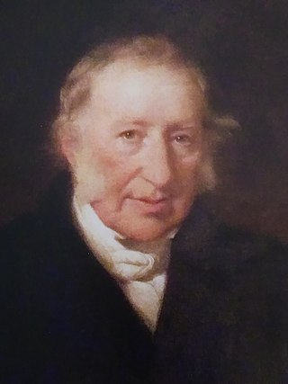
<span class="mw-page-title-main">Demographics of New Brunswick</span>

New Brunswick is one of Canada's three Maritime provinces and the only officially bilingual province in the country. The provincial Department of Finance estimates that the province's population in 2006 was 729,997 of which the majority is English-speaking but with a substantial French-speaking minority of mostly Acadian origin.

<span class="mw-page-title-main">Inkerman Parish, New Brunswick</span> Parish in New Brunswick, Canada

Inkerman is a geographic parish in Gloucester County, New Brunswick, Canada.

<span class="mw-page-title-main">Caraquet Parish, New Brunswick</span> Parish in New Brunswick, Canada

Caraquet is a geographic parish in Gloucester County, New Brunswick, Canada.

<span class="mw-page-title-main">Shippegan Parish, New Brunswick</span> Parish in New Brunswick, Canada

Shippegan is a geographic parish in Gloucester County, New Brunswick, Canada. Located in the northeastern corner of the province at the end of the Acadian Peninsula, the parish consists of the three main islands of Taylor, Lamèque, and Miscou, along with several smaller islands and tidal wetlands; Taylor Island is now joined to the mainland by an isthmus, which is crossed by a causeway.

<span class="mw-page-title-main">Allardville Parish, New Brunswick</span> Parish in New Brunswick, Canada

Allardville is a geographic parish in Gloucester County, New Brunswick, Canada,

<span class="mw-page-title-main">Caraquet</span> Town in New Brunswick, Canada

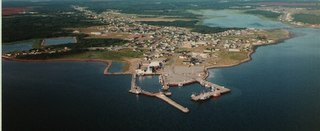
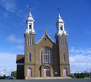
Caraquet is a town in Gloucester County, New Brunswick, Canada.

<span class="mw-page-title-main">Black Canadians in New Brunswick</span>

Black Canadians in New Brunswick refers to Black Canadians from the province of New Brunswick, notably of those whose ancestors, much like those of Black Nova Scotians, originated from the Colonial United States as slaves or freemen and arrived in New Brunswick during the 18th and early 19th centuries. As of the 2021 Canadian census, 12,155 Black people live in New Brunswick, making them the largest visible minority group in the province. The first recorded Black person in present-day New Brunswick was a Black man from New England who was forcibly taken during a French raid in the late 17th century.

References

  1. 1 2 "Women win mayoral races in N.B.'s 3 biggest cities". CBC News.
  2. 1 2 3 "Census Profile of Shippagan, Town (TV)". Statistics Canada. 6 December 2022. Retrieved 21 January 2023.
  3. "Chapter I-13: Interpretation Act" (PDF). Government of New Brunswick. p. 21. Retrieved 9 July 2020.
  4. Regulation 81-110 under the Municipalities Act.
  5. "Local Governments Establishment Regulation – Local Governance Act". Government of New Brunswick. 12 October 2022. Retrieved 21 January 2023.
  6. "RSC 4 Acadian Peninsula Regional Service Commission". Government of New Brunswick. Retrieved 21 January 2023.
  7. Donat Robichaud, "ROBICHAUX (Robichaud, Robicheau), JEAN-BAPTISTE" (1983, DCB)
  8. LeBlanc, Hillary (12 August 2022). "Meet Kassim Doumbia, New Brunswick's First Black Mayor". byblacks.com. Retrieved 9 February 2024.
  9. William Francis Ganong (1905). Historical-geographical documents relating to New Brunswick. Vol. 2. Saint-Jean: New Brunswick Historical Society.
  10. Donat Robichaud, Le Grand Chipagan - Histoire de Shippagan Beresford, 1976. pp. 19-20.
  11. Mark Barbour (September 2009). "Huit localités du Nouveau-Brunswick changent de nom" . Retrieved 28 September 2009..
  12. "2016 Community Profiles". 2016 Canadian Census . Statistics Canada. 12 August 2021. Retrieved 11 August 2019.
  13. "2011 Community Profiles". 2011 Canadian Census . Statistics Canada. 21 March 2019. Retrieved 5 April 2014.
  14. "2006 Community Profiles". 2006 Canadian Census . Statistics Canada. 20 August 2019.
  15. "2001 Community Profiles". 2001 Canadian Census . Statistics Canada. 18 July 2021.
  16. 1 2 Statistics Canada: 1996, 2001, 2006, 2011 census
  17. 2011 Statistics Canada Census Profile: Shippagan, New Brunswick
  18. "Census Profile, 2016 Census: Shippagan, Town". Statistics Canada. Retrieved 11 August 2019.
  19. The Office of the Secretary to the Governor General. "Shippagan [Civil Institution]". reg.gg.ca. Retrieved 23 December 2020.


47°44′38″N64°43′4″W / 47.74389°N 64.71778°W / 47.74389; -64.71778 (Shippagan)