Drummond Parish, New Brunswick

Last updated

Drummond
Victoria County NB - Drummond Parish.PNG
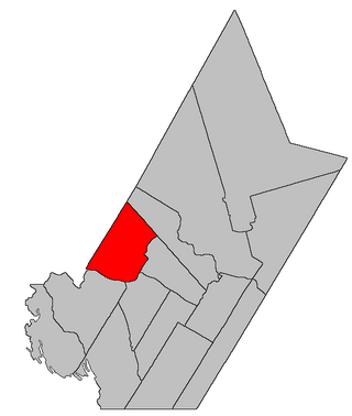
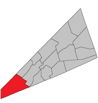
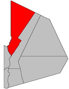
Location within Victoria County, New Brunswick.
Coordinates: 47°19′03″N67°30′36″W / 47.3175°N 67.51°W / 47.3175; -67.51
Country Flag of Canada (Pantone).svg  Canada
Province Flag of New Brunswick.svg  New Brunswick
County Victoria
Erected1872
Area
[1]
  Land1,013.66 km2 (391.38 sq mi)
Population
 (2021) [1]
  Total2,095
  Density2.1/km2 (5/sq mi)
  Change 2016-2021
Decrease2.svg 2.9%
  Dwellings
899
Time zone UTC-4 (AST)
  Summer (DST) UTC-3 (ADT)
Figures do not include portions within the town of Grand Falls and the village of Drummond

Drummond is a geographic parish in Victoria County, New Brunswick, Canada. [4]

Contents

For governance purposes it is divided between the town of Grand Falls, [5] the town of Vallée-des-Rivières, [lower-alpha 1] and the Northwest rural district, [6] both of which are members of the Northwest Regional Service Commission. [7]

Prior to the 2023 governance reform, for governance purposes it was divided between the village of Drummond, the town of Grand Falls, and the local service district of the parish of Drummond. [8]

Origin of name

The parish may have been named in honour of General Sir Gordon Drummond, [9] former Governor General of the Canadas.

Drummond was originally a neighbour of Gordon Parish before the erections of Denmark and Lorne Parishes.

History

Drummond was erected in 1872 from Grand Falls Parish. [10] It included Denmark Parish.

In 1875 the county line was altered and part of Drummond was transferred to Victoria County. [11]

In 1927 the area within the municipal limits of the town of Grand Falls was removed from Drummond. [12]

In 1936 much of Drummond was erected as Denmark Parish. [13] Three months later the inland boundary was simplified, returning part of Denmark to Drummond. [14]

In 1955 part of Drummond was added to the town of Grand Falls. [15]

Boundaries

Drummond Parish is bounded: [2] [16] [17]

Communities

Communities at least partly within the parish. [16] [17] [18] bold indicates an incorporated municipality

Bodies of water

Bodies of water [lower-alpha 4] at least partly within the parish. [16] [17] [18]

Other notable places

Parks, historic sites, and other noteworthy places at least partly within the parish. [16] [17] [18] [19]

Demographics

Parish population totals do not include village of Drummond and portion within Grand Falls

See also

Notes

  1. An area along Highway 17, as shown by the original map of Vallée-des-Rivières, with the unchanged boundaries for the new town as an overlay on the pre-2023 governance boundaries; this map is still available in thumbnail form on the NWRSC governance reform map page. [6]
  2. The exact location of the Mill Lease is not stated and doesn't appear on cadastral or highway maps.
  3. This is the only instance in the Territorial Division Act where an incorporated town appears; Grand Falls town in the Territorial Division Act is much smaller in area than the modern municipality of Grand Falls
  4. Not including brooks, ponds or coves.

Related Research Articles

<span class="mw-page-title-main">Southampton Parish, New Brunswick</span> Parish in New Brunswick, Canada

Southampton is a geographic parish in York County, New Brunswick, Canada.

<span class="mw-page-title-main">Eldon Parish, New Brunswick</span> Parish in New Brunswick, Canada

Eldon is a geographic parish in Restigouche County, New Brunswick, Canada.

<span class="mw-page-title-main">Saint-Quentin Parish, New Brunswick</span> Parish in New Brunswick, Canada

Saint-Quentin is a geographic parish in Restigouche County, New Brunswick, Canada.

<span class="mw-page-title-main">Saint-François Parish, New Brunswick</span> Parish in New Brunswick, Canada

Saint-François is a geographic parish in Madawaska County, New Brunswick, Canada.

<span class="mw-page-title-main">Lac Baker Parish, New Brunswick</span> Parish in New Brunswick, Canada

Lac Baker is a geographic parish in Madawaska County, New Brunswick, Canada.

<span class="mw-page-title-main">Clair Parish, New Brunswick</span> Parish in New Brunswick, Canada

Clair is a geographic parish in Madawaska County, New Brunswick, Canada.

<span class="mw-page-title-main">Baker Brook Parish, New Brunswick</span> Parish in New Brunswick, Canada

Baker Brook is a geographic parish in Madawaska County, New Brunswick, Canada.

<span class="mw-page-title-main">Madawaska Parish, New Brunswick</span> Parish in New Brunswick, Canada

Madawaska is a geographic parish in Madawaska County, New Brunswick, Canada.

<span class="mw-page-title-main">Saint-Jacques Parish, New Brunswick</span> Parish in New Brunswick, Canada

Saint-Jacques is a geographic parish in Madawaska County, New Brunswick, Canada. The parish consists of two discontiguous portions separated by Saint-Joseph Parish.

<span class="mw-page-title-main">Saint-Joseph Parish, New Brunswick</span> Parish in New Brunswick, Canada

Saint-Joseph is a geographic parish in Madawaska County, New Brunswick, Canada.

<span class="mw-page-title-main">Saint-Basile Parish, New Brunswick</span> Parish in New Brunswick, Canada

Saint-Basile is a geographic parish in Madawaska County, New Brunswick, Canada.

<span class="mw-page-title-main">Rivière-Verte Parish, New Brunswick</span> Parish in New Brunswick, Canada

Rivière-Verte is a geographic parish in Madawaska County, New Brunswick, Canada.

<span class="mw-page-title-main">Sainte-Anne Parish, New Brunswick</span> Parish in New Brunswick, Canada

Sainte-Anne is a geographic parish in Madawaska County, New Brunswick, Canada.

<span class="mw-page-title-main">Notre-Dame-de-Lourdes Parish, New Brunswick</span> Parish in New Brunswick, Canada

Notre-Dame-de-Lourdes is a geographic parish in Madawaska County, New Brunswick, Canada.

<span class="mw-page-title-main">Saint-Léonard Parish, New Brunswick</span> Parish in New Brunswick, Canada

Saint-Léonard is a geographic parish in Madawaska County, New Brunswick, Canada.

<span class="mw-page-title-main">Saint-André Parish, New Brunswick</span> Parish in New Brunswick, Canada

Saint-André is a geographic parish in Madawaska County, New Brunswick, Canada.

<span class="mw-page-title-main">Southesk Parish, New Brunswick</span> Parish in New Brunswick, Canada

Southesk is a geographic parish in Northumberland County, New Brunswick, Canada.

<span class="mw-page-title-main">Denmark Parish, New Brunswick</span> Parish in New Brunswick, Canada

Denmark is a geographic parish in Victoria County, New Brunswick, Canada.

<span class="mw-page-title-main">Westfield Parish, New Brunswick</span> Parish in New Brunswick, Canada

Westfield is a geographic parish in Kings County, New Brunswick, Canada.

<span class="mw-page-title-main">Saint James Parish, New Brunswick</span> Parish in Canada

Saint James is a geographic parish in Charlotte County, New Brunswick, Canada, located north of St. Stephen.

References

  1. 1 2 "Census Profile". Statistics Canada. 26 October 2022. Retrieved 29 October 2022.
  2. 1 2 "Chapter T-3 Territorial Division Act". Government of New Brunswick. Retrieved 24 January 2023.
  3. "Chapter I-13 Interpretation Act". Government of New Brunswick. Retrieved 24 January 2023.
  4. The Territorial Division Act [2] divides the province into 152 parishes, the cities of Saint John and Fredericton, and one town of Grand Falls. The Interpretation Act [3] clarifies that parishes include any local government within their borders.
  5. "Northwest Regional Service Commission: RSC 1". Government of New Brunswick. Retrieved 24 January 2023.
  6. 1 2 "Northwest Regional Service Commission: RD 1". Government of New Brunswick. Retrieved 24 January 2023.
  7. "Regions Regulation – Regional Service Delivery Act". Government of New Brunswick. 21 July 2022. Retrieved 24 January 2023.
  8. "Local Service Districts Regulation - Municipalities Act". Government of New Brunswick. 25 June 2021. Retrieved 24 January 2023.
  9. Ganong, William F. (1896). A Monograph of the Place-Nomenclature of the Province of New Brunswick. Royal Society of Canada. p. 231. Retrieved 17 March 2021.
  10. "35 Vic. c. 34 An Act to erect part of the Parish of Grand Falls in the County of Victoria, into a separate Town or Parish.". Acts of the General Assembly of Her Majesty's Province of New Brunswick. Passed in the Month of April 1872. Fredericton: Government of New Brunswick. 1872. pp. 67–68. Available as a free ebook from Google Books.
  11. "38 Vic. c. 101 An Act to alter the Division line between the Counties of Victoria and Madawaska.". Acts of the General Assembly of Her Majesty's Province of New Brunswick. Passed in the Month of April 1875. Fredericton: Government of New Brunswick. 1875. pp. 359–360. Available as a free ebook from Google Books.
  12. "Chapter 2. Respecting the Division of the Province into Counties, Towns and Parishes.". The Revised Statutes of New Brunswick 1927 Volume I. Fredericton: Government of New Brunswick. 1927. pp. 18–64.
  13. "25 Geo. V c. 19 An Act To Amend Chapter 2, of The Revised Statutes, 1927, So As To Divide the Parish of Drummond in the County of Victoria.". Acts of the Legislative Assembly of New Brunswick Passed During the Session of 1935. Fredericton: Government of New Brunswick. 1935. pp. 160–164.
  14. "1 Edward VIII c. 54 An Act to amend Chapter 19 of 25 George V (1935), to correct the Dividing Line between the Parish of Drummond and the Parish of Denmark, in the County of Victoria.". Acts of the Legislative Assembly of New Brunswick Passed During the Session of 1936. Fredericton: Government of New Brunswick. 1936. pp. 241–242.
  15. "4 Elizabeth 2, 1955, c. 113 An Act to Amend An Act to Incorporate the Town of Grand Falls 1890". Acts of the Legislature of New Brunswick Passed During the Session of 1955. Fredericton: Government of New Brunswick. 1955. pp. 440–442.
  16. 1 2 3 4 "No. 22". Provincial Archives of New Brunswick. Department of Natural Resources and Energy Development. Retrieved 23 June 2021. Remainder of parish on maps 23, 35, 36, 45, 46, 54, and 63 at same site.
  17. 1 2 3 4 "081" (PDF). Transportation and Infrastructure. Government of New Brunswick. Retrieved 23 June 2021. Remainder of parish on mapbooks 082, 101–103, 123–125, 145, 146, 162, 163, 178, 179, and 193 at same site.
  18. 1 2 3 "Search the Canadian Geographical Names Database (CGNDB)". Government of Canada. Retrieved 3 July 2021.
  19. "Explore New Brunswick's Protected Natural Areas". GeoNB. Retrieved 3 July 2021.
  20. Statistics Canada: 1996, 2001, 2006 census
  21. 2011 Statistics Canada Census Profile: Drummond Parish, New Brunswick
  22. 1 2 "Census Profile, 2016 Census: Drummond, Parish [Census subdivision], New Brunswick". Statistics Canada. Retrieved 1 October 2019.


47°19′03″N67°30′36″W / 47.31750°N 67.51000°W / 47.31750; -67.51000 (Drummond Parish, New Brunswick)