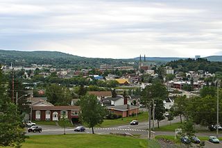
Edmundston is a city in Madawaska County, New Brunswick, Canada.

York County is located in west-central New Brunswick, Canada. The county contains the provincial capital, Fredericton. Outside the city, farming and forestry are two major industries in the county, which is bisected by the Saint John River. The Southwest Miramichi River flows through the northern section of the county.
Florenceville-Bristol is a town in the northwest part of Carleton County, New Brunswick, Canada. The town is located on the banks of the Saint John River. As of 2016, the population was 1,604.
Juniper is a hamlet in Carleton County, New Brunswick, Canada. Juniper is located in Aberdeen Parish. It is situated on Route 107, which runs from Route 105 at Bristol, northeast to Juniper, and then bends southeast towards Napadogan and Deersdale. Geographic coordinates: 46° 33' North, 67° 13' West; elevation 899 ft.

Nackawic is a town located 65 km west of the city of Fredericton on the east bank of the Saint John River in New Brunswick, Canada. The town occupies an area of about 9 km² and is surrounded by the parishes of Southampton and Queensbury with the Village of Millville 10 km to the north. Nackawic is centered on the intersection of Route 105 and Route 605.

Woodstock is a town in Carleton County, New Brunswick, Canada on the Saint John River, 103 km upriver from Fredericton at the mouth of the Meduxnekeag River. It is near the Canada–United States border and Houlton, Maine and the intersection of Interstate 95 and the Trans-Canada Highway making it a transportation hub. It is also a service centre for the potato industry and for more than 26,000 people in the nearby communities of Hartland, Florenceville-Bristol, Centreville, Bath, Meductic, and Canterbury for shopping, employment and entertainment.

Hampton is a town in Kings County, New Brunswick, Canada.

Grand Bay–Westfield is a Canadian suburb outside Saint John in the western part of Kings County, New Brunswick.

Saint-Léonard is a Canadian town in Madawaska County, New Brunswick.

Zealand is a Canadian rural community in York County, New Brunswick close to the intersection of Route 104 and Route 616.
The Tobique River is a river in northwestern New Brunswick, Canada. The river rises from Nictau Lake in Mount Carleton Provincial Park and flows for 148 kilometres to its confluence with the Saint John River near Perth-Andover.

Tyne Valley is a municipality that holds community status in Prince Edward Island, Canada. It is located in Prince County. Incorporated in 1966, the community is located in the township of Lot 13 at the intersection of Routes 12 and 167.
Peel is a Canadian rural community in Carleton County, New Brunswick. It is located on the east side of the Saint John River, 5.71 km NNW of Hartland, on the road to Stickney. It is part of Peel Parish.
Targettville is a community in the Local Service District of Weldford Parish, located on the Richibucto River, 7.55 km NE of Fords Mills, on the road to Browns Yard. Today the community has a popular outdoor skating rink and recreation center with an outdoor playground. The facility holds community events such as music nights and family re-unions as well as having a very active program for young children during the summer.

for the community named Molus River, see Molus River
Northampton is a Canadian community in Carleton County, New Brunswick.

Ford's Mills is a settlement in Weldford Parish, New Brunswick at the intersection of Route 470 and Route 510 on the Richibucto River.
McGivney is a settlement in New Brunswick, located 14.78 km SW of Boiestown, on the Canadian National Railway line, in Stanley Parish, York County.
Route 550 is a 30-kilometre (19 mi) long north-south secondary highway in the northwest portion of New Brunswick, Canada.
The Becaguimec Stream is a minor tributary of the Saint John River in the Canadian Province of New Brunswick. It rises in the hilly woods along the county line dividing Carleton County, Canada from York County, Canada in the western region of the province. Its watershed is adjacent to the South Branch of the Southwest Miramichi River, the Nashwaak River, the Keswick River and the Nackawic Stream.
