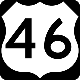
U.S. Route 46 (US 46) is an east–west U.S. Highway completely within the state of New Jersey, running for 75.34 mi (121.25 km), making it the shortest signed, non-spur U.S. Highway. The west end is at an interchange with Interstate 80 (I-80) and Route 94 in Columbia, Warren County, on the Delaware River. The east end is in the middle of the George Washington Bridge over the Hudson River in Fort Lee, Bergen County, while the route is concurrent with I-95 and US 1-9. Throughout much of its length, US 46 is closely paralleled by I-80. US 46 is a major local and suburban route, with some sections built to or near freeway standards and many other sections arterials with jughandles. The route runs through several communities in the northern part of New Jersey, including Hackettstown, Netcong, Dover, Parsippany-Troy Hills, Wayne, Clifton, Ridgefield Park, Palisades Park, and Fort Lee. It crosses over the Upper Passaic River at several points. The road has been ceremonially named the United Spanish–American War Veterans Memorial Highway.

The Trans Canada Trail, officially named The Great Trail between September 2016 and June 2021, is a cross-Canada system of greenways, waterways, and roadways that stretches from the Atlantic to the Pacific to the Arctic oceans. The trail extends over 24,000 km (15,000 mi); it is now the longest recreational, multi-use trail network in the world. The idea for the trail began in 1992, shortly after the Canada 125 celebrations. Since then it has been supported by donations from individuals, corporations, foundations, and all levels of government.
Route 2 is a major provincial highway in the Canadian province of New Brunswick, carrying the main route of the Trans-Canada Highway in the province. The highway connects with Autoroute 85 at the border with Quebec and Highway 104 at the border with Nova Scotia, as well as with traffic from Interstate 95 in the U.S. state of Maine via the short Route 95 connector. A core route in the National Highway System, Route 2 is a four-lane freeway in its entirety, and directly serves the cities of Edmundston, Fredericton, and Moncton.
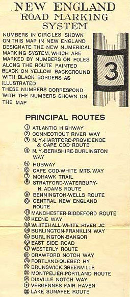
The New England road marking system was a regional system of marked numbered routes in the six-state region of New England in the United States. The routes were marked by a yellow rectangular sign with black numbers and border. Many signs were painted on telephone poles. The routes were approved by the highway departments of the six New England states in April 1922.

New Hampshire Route 25 is a 96.62-mile (155.49 km) long east–west state highway in New Hampshire. It runs completely across the state from Vermont to Maine.

New York State Route 36 (NY 36) is a north–south state highway in the western part of New York in the United States. The highway extends for 95 miles (153 km) from the Pennsylvania state line at Troupsburg, Steuben County northward to Ogden, Monroe County, where it ends at an intersection with NY 31. Along the way, NY 36 passes through the villages of Canisteo, Dansville, Mount Morris, Caledonia, and Churchville and the city of Hornell. The section of the route between Dansville and Mount Morris closely parallels Interstate 390 (I-390); however, from Dansville south and Mount Morris north, NY 36 serves as a regionally important highway, connecting to I-86, U.S. Route 20A (US 20A), US 20, and I-490 as it heads north. At its south end, NY 36 connects to Pennsylvania Route 249 (PA 249).

Trunk 2 is part of the Canadian province of Nova Scotia's system of Trunk Highways. The route runs from Halifax to Fort Lawrence on the New Brunswick border. Until the 1960s, Trunk 2 was the Halifax area's most important highway link to other provinces, and was part of a longer Interprovincial Highway 2 which ended in Windsor, Ontario. The controlled access Highway 102 and Highway 104 now carry most arterial traffic in the area, while Trunk 2 serves regional and local traffic.
Route 105 is a collector highway in New Brunswick running from Route 10 in Youngs Cove to Route 108 in Grand Falls, mostly along the east and north banks of the Saint John River, over a distance of 307.0 kilometres (190.8 mi). Route 105 consists largely of former alignments of Route 2 and runs parallel to Route 2 over its entire length.

Route 106 is a highway in New Brunswick, Canada; running from an intersection with Route 1 and western intersection in Route 905 in Petitcodiac to the intersection of Trans-Canada Highway and the southern terminus of Route 940 at Sackville; a distance of 91.8 kilometres.

New York State Route 415 (NY 415) is a state highway located entirely within Steuben County, New York, in the United States. It is a 42.83-mile (68.93 km) north–south trunk road that parallels in part, the Cohocton River, Interstate 86 (I-86) and I-390. The southern terminus of the route is at an intersection with NY 414 in the city of Corning. Its northern terminus is at a junction with NY 15 and NY 21 south of the village of Wayland. NY 415 serves several villages bypassed by the Southern Tier Expressway and I-390, such as Bath and Cohocton. The road also runs concurrent with New York State Bicycle Route 17 from its southern terminus to County Route 70A (CR 70A) in Avoca.
Route 108 is a highway in New Brunswick, Canada; running from Trans-Canada Highway exit 75 near Grand Falls to Route 8 exit 163 at Derby Junction ; a distance of 202.9 kilometres.
Route 114 is a 137.6 km (85.5 mi) Canadian secondary highway in southeastern New Brunswick.

U.S. Route 40 in the U.S. state of Maryland runs from Garrett County in Western Maryland to Cecil County in the state's northeastern corner. With a total length of 221 miles (356 km), it is the longest numbered highway in Maryland. Almost half of the road overlaps or parallels with Interstate 68 (I-68) or I-70, while the old alignment is generally known as US 40 Alternate, US 40 Scenic, or Maryland Route 144. West of Baltimore, in the Piedmont and Appalachian Mountains / Blue Ridge region of the Western Maryland panhandle of the small state, the portions where it does not overlap an Interstate highway are mostly two-lane roads. The portion northeast of Baltimore going toward Wilmington in northern Delaware and Philadelphia in southeastern Pennsylvania is a four-lane divided highway, known as the Pulaski Highway. This section crosses the Susquehanna River at the north end of the Chesapeake Bay on the Thomas J. Hatem Memorial Bridge.
Route 385 is a 88-kilometre (55 mi) long mostly east–west secondary highway in the northwest portion of New Brunswick, Canada.
Route 390 is a 12-kilometre (7.5 mi) long mostly east–west secondary highway in the northwest portion of New Brunswick, Canada.
Route 420 is a 35-kilometre (22 mi) long mostly east–west secondary highway in the northwest portion of New Brunswick, Canada.
Route 430 is a 40-kilometre-long (25 mi) mostly north–south secondary highway in the northwest portion of New Brunswick, Canada.
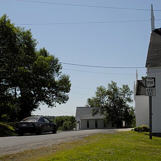
Route 715 is a 53.2-kilometre (33.1 mi) long local highway in Queens County, New Brunswick. Its western terminus is in Jemseg at Route 695 near its interchange with Route 2 and its eastern terminus is in Coles Island at Route 10 and Route 112. It is signed as an east–west highway although its westernmost portion along the Saint John River runs nearly due north and south.
Route 175 is a 27 km (17 mi)-long mostly east–west secondary highway in southwest New Brunswick, Canada.

Vermont Route 118 (VT 118) is a state highway in the U.S. state of Vermont. The highway runs 28.549 miles (45.945 km) from VT 100 in Eden north to VT 108 in Berkshire. VT 118 connects several towns in northern Lamoille County and eastern Franklin County, including the covered bridge–rich town of Montgomery. The town of Berkshire maintains the highway north of VT 105.
