Lac Baker Parish, New Brunswick

Last updated

Lac Baker
Lac-Baker NB.JPG
Madawaska County NB - Lac-Baker Parish.PNG
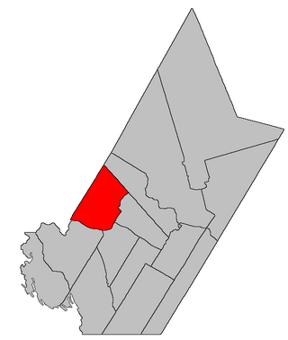
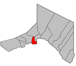
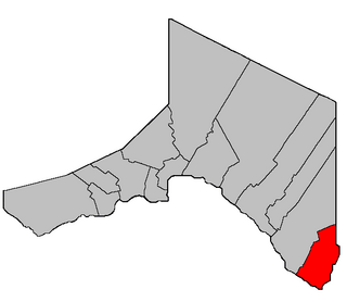
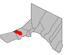
Location within Madawaska County.
Coordinates: 47°22′N68°41′W / 47.36°N 68.68°W / 47.36; -68.68
Country Flag of Canada (Pantone).svg  Canada
Province Flag of New Brunswick.svg  New Brunswick
County Madawaska
Erected1912
Area
[1]
  Land24.30 km2 (9.38 sq mi)
Population
 (2016) [1]
  Total5
  Density0.2/km2 (0.5/sq mi)
  Change 2011-2016
No change
  Dwellings
4
Time zone UTC-4 (AST)
  Summer (DST) UTC-3 (ADT)
Figures do not include portion within village of Lac Baker
No census data available after 2016

Lac Baker is a geographic parish in Madawaska County, New Brunswick, Canada. [2]

Contents

Before 2023, it was divided for governance purposed between the village of Lac Baker [3] and the incorporated rural community of Haut-Madawaska, [4] both of which are members of the Northwest Regional Service Commission (NWRSC). [5]

Origin of name

The parish takes its name from Baker Lake, which takes its name from John Baker, an American leader in the Aroostook War. [6] Baker remained in the area after the boundary settlement awarded the area to New Brunswick.

History

Lac Baker was erected as Baker Lake in 1912 from Clair Parish; [7] the boundary was slightly altered later that year. [8]

The parish was renamed Lac Baker and its boundaries affected by the major reorganisation of Madawaska County parish lines in 1946. [9]

Boundaries

Lac Baker Parish is bounded: [2] [10] [11] [12]

Communities

Communities at least partly within the parish. [10] [11] [12] bold indicates an incorporated municipality; italics indicate a name no longer in official use

Bodies of water

Bodies of water [lower-alpha 2] at least partly in the parish. [10] [11] [12]

Islands

Islands at least partly in the parish. [10] [11] [12]

Census data

Census data refers only to the Census subdivision of the parish, much of which was annexed by the village of Lac Baker in 2008. [13]

Population

Canada census – Lac Baker community profile
2021 2016 2011
Population685 (-0.7% from 2016)5 (-83.3% from 2011)5 (-83.3% from 2006)
Land area37.24 km2 (14.38 sq mi)24.30 km2 (9.38 sq mi)24.29 km2 (9.38 sq mi)
Population density18.4/km2 (48/sq mi)0.2/km2 (0.52/sq mi)
Median age58.8 (M: 59.6, F: 58.4)N/A (M: , F: )N/A (M: , F: )
Private dwellings459 (total)  336 (occupied)4 (total) 4 (total) 
Median household income$69,000$.N/A$.N/A
Notes: 2011 and 2016 income data for this area has been suppressed for data quality or confidentiality reasons.
References: 2021 [14] 2016 [15] 2011 [16] earlier [17] [18]
Historical Census Data - Lac Baker Parish, New Brunswick
YearPop.±%
1991 508    
1996 472−7.1%
2001 488+3.4%
YearPop.±%
2006 566+16.0%
2006A 30−94.7%
2011 5−83.3%
YearPop.±%
2011 5+0.0%
[19] [1]
(A) adjustment due to boundary change.

Language

Canada Census Mother Tongue - Lac Baker Parish, New Brunswick
2011 and 2016 language data for this area has been suppressed for data quality or confidentiality reasons. [19]
CensusTotal
French
English
French & English
Other
YearResponsesCountTrendPop %CountTrendPop %CountTrendPop %CountTrendPop %
2011
n/a
n/aSteady2.svg 0.0%0.00%n/aSteady2.svg 0.0%0.00%n/aSteady2.svg 0.0%0.00%n/aSteady2.svg 0.0%0.00%
2006
570
520Increase2.svg 9.6%0.00%50Increase2.svg 70.0%0.00%0Steady2.svg 0.0%0.00%0Steady2.svg 0.0%0.00%
2001
485
470Increase2.svg 1.1%96.91%15Increase2.svg 33.3%3.09%0Steady2.svg 0.0%0.00%0Steady2.svg 0.0%0.00%
1996
475
465n/a97.89%10n/a2.11%0n/a0.00%0n/a0.00%

See also

Notes

  1. WP:ENG is ignored when it would result in a clumsy construction.
  2. Not including brooks, ponds or coves.

Related Research Articles

<span class="mw-page-title-main">Inkerman Parish, New Brunswick</span> Parish in New Brunswick, Canada

Inkerman is a geographic parish in Gloucester County, New Brunswick, Canada.

<span class="mw-page-title-main">Southampton Parish, New Brunswick</span> Parish in New Brunswick, Canada

Southampton is a geographic parish in York County, New Brunswick, Canada.

<span class="mw-page-title-main">Paquetville Parish, New Brunswick</span> Parish in New Brunswick, Canada

Paquetville is a geographic parish in Gloucester County, New Brunswick, Canada.

<span class="mw-page-title-main">Saint-Isidore Parish, New Brunswick</span> Parish in New Brunswick, Canada

Saint-Isidore is a geographic parish in Gloucester County, New Brunswick, Canada.

<span class="mw-page-title-main">Allardville Parish, New Brunswick</span> Parish in New Brunswick, Canada

Allardville is a geographic parish in Gloucester County, New Brunswick, Canada,

<span class="mw-page-title-main">Saint-François Parish, New Brunswick</span> Parish in New Brunswick, Canada

Saint-François is a geographic parish in Madawaska County, New Brunswick, Canada.

<span class="mw-page-title-main">Clair Parish, New Brunswick</span> Parish in New Brunswick, Canada

Clair is a geographic parish in Madawaska County, New Brunswick, Canada.

<span class="mw-page-title-main">Baker Brook Parish, New Brunswick</span> Parish in New Brunswick, Canada

Baker Brook is a geographic parish in Madawaska County, New Brunswick, Canada.

<span class="mw-page-title-main">Saint-Hilaire Parish, New Brunswick</span> Parish in New Brunswick, Canada

Saint-Hilaire is a geographic parish in Madawaska County, New Brunswick, Canada.

<span class="mw-page-title-main">Madawaska Parish, New Brunswick</span> Parish in New Brunswick, Canada

Madawaska is a geographic parish in Madawaska County, New Brunswick, Canada.

<span class="mw-page-title-main">Saint-Jacques Parish, New Brunswick</span> Parish in New Brunswick, Canada

Saint-Jacques is a geographic parish in Madawaska County, New Brunswick, Canada. The parish consists of two discontiguous portions separated by Saint-Joseph Parish.

<span class="mw-page-title-main">Saint-Joseph Parish, New Brunswick</span> Parish in New Brunswick, Canada

Saint-Joseph is a geographic parish in Madawaska County, New Brunswick, Canada.

<span class="mw-page-title-main">Saint-Basile Parish, New Brunswick</span> Parish in New Brunswick, Canada

Saint-Basile is a geographic parish in Madawaska County, New Brunswick, Canada.

<span class="mw-page-title-main">Rivière-Verte Parish, New Brunswick</span> Parish in New Brunswick, Canada

Rivière-Verte is a geographic parish in Madawaska County, New Brunswick, Canada.

<span class="mw-page-title-main">Sainte-Anne Parish, New Brunswick</span> Parish in New Brunswick, Canada

Sainte-Anne is a geographic parish in Madawaska County, New Brunswick, Canada.

<span class="mw-page-title-main">Notre-Dame-de-Lourdes Parish, New Brunswick</span> Parish in New Brunswick, Canada

Notre-Dame-de-Lourdes is a geographic parish in Madawaska County, New Brunswick, Canada.

<span class="mw-page-title-main">Saint-Léonard Parish, New Brunswick</span> Parish in New Brunswick, Canada

Saint-Léonard is a geographic parish in Madawaska County, New Brunswick, Canada.

<span class="mw-page-title-main">Saint-André Parish, New Brunswick</span> Parish in New Brunswick, Canada

Saint-André is a geographic parish in Madawaska County, New Brunswick, Canada.

<span class="mw-page-title-main">Southesk Parish, New Brunswick</span> Parish in New Brunswick, Canada

Southesk is a geographic parish in Northumberland County, New Brunswick, Canada.

<span class="mw-page-title-main">Drummond Parish, New Brunswick</span> Parish in New Brunswick, Canada

Drummond is a geographic parish in Victoria County, New Brunswick, Canada.

References

  1. 1 2 3 "Census Profile, 2016 Census: Lac Baker, Parish [Census subdivision], New Brunswick". Statistics Canada. Retrieved 23 September 2019.
  2. 1 2 "Chapter T-3 Territorial Division Act". Government of New Brunswick. Retrieved 13 November 2020.
  3. "New Brunswick Regulation 85-6 under the Municipalities Act (O.C. 85-45)". Government of New Brunswick. Retrieved 19 July 2020.
  4. "New Brunswick Regulation 2017-3 under the Municipalities Act (O.C. 2017-52)". Government of New Brunswick. Retrieved 19 July 2020.
  5. "Communities in each of the 12 Regional Service Commissions (RSC) / Les communautés dans chacune des 12 Commissions de services régionaux (CSR)" (PDF), Government of New Brunswick, July 2017, retrieved 2 February 2021
  6. Ganong, William F. (1896). A Monograph of the Place-Nomenclature of the Province of New Brunswick. Royal Society of Canada. p. 218. Retrieved 17 March 2021.
  7. "1 Geo. V c. 46 An Act to amend Chapter 2 of The Consolidated Statutes, 1903, respecting the Division of the Province into Counties, Towns and Parishes, so far as relates to the County of Madawaska.". Acts of the Legislative Assembly of New Brunswick Passed in the Month of April, 1911. Fredericton: Government of New Brunswick. 1911. pp. 167–170.
  8. "2 Geo. V c. 16 An Act to amend Chapter 2 of the Consolidated Statutes, 1903, respecting the Division of the Province into Counties, Towns and Parishes, so far as relates to the County of Madawaska.". New Brunswick Acts of the Legislative Assembly Passed in the Months of March and April, 1912. Fredericton: Government of New Brunswick. 1912. pp. 131–132.
  9. "10 Geo. VI. c. 95 An Act to amend Chapter 2 of the Revised Statutes, 1927, respecting the division of the Province into Counties, Towns and Parishes, in so far as it relates to the County of Madawaska.". Acts of the Legislative Assembly of New Brunswick Passed During the Session of 1946. Fredericton: Government of New Brunswick. 1946. pp. 321–339.
  10. 1 2 3 4 "No. 31". Provincial Archives of New Brunswick. Department of Natural Resources and Energy Development. Retrieved 16 June 2021. Remainder of parish on map 32 at same site.
  11. 1 2 3 4 "118" (PDF). Transportation and Infrastructure. Government of New Brunswick. Retrieved 16 June 2021. Remainder of parish on mapbook 119 at same site.
  12. 1 2 3 4 "Search the Canadian Geographical Names Database (CGNDB)". Government of Canada. Retrieved 16 June 2021.
  13. "New Brunswick Regulation 2008-35 under the Municipalities Act (O.C. 2008-108)" (PDF). The Royal Gazette. 166. Fredericton, New Brunswick: Office of the Queen's Printer: 573–574. 26 March 2008. ISSN   1714-9428 . Retrieved 28 July 2020.
  14. "2021 Community Profiles". 2021 Canadian Census . Statistics Canada. 4 February 2022. Retrieved 19 October 2023.
  15. "2016 Community Profiles". 2016 Canadian Census . Statistics Canada. 12 August 2021. Retrieved 23 September 2019.
  16. "2011 Community Profiles". 2011 Canadian Census . Statistics Canada. 21 March 2019. Retrieved 22 March 2014.
  17. "2006 Community Profiles". 2006 Canadian Census . Statistics Canada. 20 August 2019.
  18. "2001 Community Profiles". 2001 Canadian Census . Statistics Canada. 18 July 2021.
  19. 1 2 Statistics Canada: 1996, 2001, 2006, 2011 census


47°21′36″N68°40′48″W / 47.36000°N 68.68000°W / 47.36000; -68.68000 (Lac Baker Parish, New Brunswick)