The Penobscot River is a 109-mile-long (175 km) river in the U.S. state of Maine. Including the river's West Branch and South Branch increases the Penobscot's length to 264 miles (425 km), making it the second-longest river system in Maine and the longest entirely in the state. Its drainage basin contains 8,610 square miles (22,300 km2).

The Damariscotta River is a 19.0-mile-long (30.6 km) tidal river in Lincoln County, Maine, that empties into the Atlantic Ocean. Damariscotta is an old Abenaki word for "river of many fishes". There are 2,500-year-old oyster shell middens (heaps) along the banks of the Damariscotta River, which occupies a drowned river valley leading to the Gulf of Maine, a large embayment of the Atlantic Ocean.
The Cross River is a 5.0-mile-long (8.0 km) tidal river in Maine. It is a tributary of the Sheepscot River.
The East Branch Eastern River is a 6.5-mile-long (10.5 km) river in Maine. It is part of the Kennebec River watershed. It rises in the town of Whitefield and flows southwest to its confluence with the West Branch Eastern River at East Pittston to form the Eastern River.
The East Branch Oyster River is a tributary of the Oyster River in Knox County, Maine. From its source in Rockland, the stream runs 4.8 miles (7.7 km) southwest to its confluence with the main stem of the Oyster River, on the border between Warren and Thomaston.
The East Branch Pleasant River is a 6.2-mile-long (10.0 km) tributary of the Pleasant River in the U.S. state of Maine. The Pleasant River is a tributary of the Androscoggin River, which flows southeast to the tidal Kennebec River and the Atlantic Ocean.
The Eastern River is a 14.0-mile-long (22.5 km) tributary of the Kennebec River in Maine. It rises in East Pittston at the confluence of its west and east branches and flows southwest past Dresden Mills to its mouth at the Kennebec, at the town boundary between Dresden and Perkins.
The Marsh River is a 3.9-mile-long (6.3 km) tidal river in Newcastle, Maine, in the United States. It is a tributary of the Sheepscot River.
The New Meadows River is a 12-mile-long (19 km) tidal river in Maine, flowing into the northern end of Casco Bay. It serves as the boundary between Cumberland and Sagadahoc counties for its entire length.

The Sheepscot River is a 66-mile-long (106 km) river in the U.S. state of Maine. Its lower portion is a complex island estuary with connections to the Kennebec River downstream of Merrymeeting Bay.
The South Branch Marsh River is a 3.0-mile-long (4.8 km) tidal river in the towns of Prospect and Frankfort in Waldo County, Maine. It joins the North Branch Marsh River to form Marsh Bay, a short arm of the tidal Penobscot River.
The South Branch Sunday River is a 2.5-mile-long (4.0 km) mountain stream in western Maine. It is a tributary of the Sunday River, which flows to the Androscoggin River and ultimately to the Kennebec River and the Atlantic Ocean.
The Sprague River is a 2.5-mile-long (4.0 km) river in the town of Phippsburg, Maine. It flows primarily through tidal marsh and empties into the Atlantic Ocean, 1.5 miles (2.4 km) west of the mouth of the Morse River and 3.5 miles (5.6 km) west of the mouth of the Kennebec River.

The Spurwink River is a 4.6-mile-long (7.4 km) primarily tidal river in Cumberland County, Maine, in the United States. It rises in the town of Cape Elizabeth and flows west, then southwest, through salt marshes to its mouth at the Atlantic Ocean. It is bridged by Maine State Route 77 at the river's approximate halfway point. From a point shortly above the bridge to the river's mouth, it forms the boundary between Cape Elizabeth to the east and the town of Scarborough to the west. The river's mouth is at the Scarborough village of Higgins Beach.
The Weskeag River is a short tidal river in Knox County, Maine. The Abenaki Indians called it Wessaweskeag, meaning "tidal creek" or "salt creek". From its source in South Thomaston, the river runs 1.2 miles (1.9 km) northeast and southeast to its confluence with Marsh Creek, then 4.2 miles (6.8 km) southeast through its estuary to the Muscle Ridge Channel of West Penobscot Bay. Its mouth is on the border between the towns of South Thomaston and Owls Head.
The West Branch Eastern River is a 10.4-mile-long (16.7 km) tributary of the Eastern River in Maine. It is part of the Kennebec River watershed. The West Branch begins near South Windsor and flows southwest through the town of Whitefield, joining the East Branch at East Pittston to form the Eastern River.
The West Branch Pleasant River is a 7.5-mile-long (12.1 km) tributary of the Pleasant River in the U.S. state of Maine. It is part of the Androscoggin River watershed, which flows to the tidal Kennebec River near its mouth at the Atlantic Ocean.
The West Branch Sheepscot River is a 24.9-mile-long (40.1 km) river in Maine. The branch originates in the northwest corner of Palermo and flows southwesterly through Branch Pond and the village of Weeks Mills in the town of China. The branch then flows southerly through the town of Windsor to a confluence with the Sheepscot River between Coopers Mills and North Whitefield. The branch is bridged by Maine State Route 3 between Branch Pond and Weeks Mills, by Maine State Route 105 at Windsor and by concurrent Maine State Routes 17 and 32 near Coopers Mills.
The Dyer River is a 20.2-mile-long (32.5 km) river in Maine. It originates along the northern boundary of the town of Jefferson with the town of Somerville and flows southwesterly through Jefferson, passing through Dyer Long Pond and near South Jefferson. It continues southwest into the town of Newcastle, passing the villages of North Newcastle and Sheepscot, where it joins the tidal Sheepscot River.
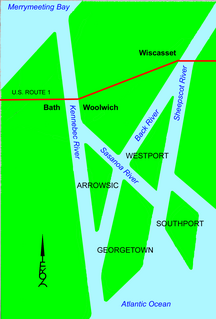
The Sasanoa River is an 8.6-mile-long (13.8 km) tidal channel in the Midcoast region of Maine, connecting the Kennebec River with the Sheepscot River.