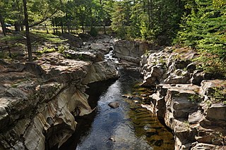
The Charles River is a 1.2-mile-long (1.9 km) channel connecting Charles Pond with the Old Course Saco River in the town of Fryeburg in western Maine, United States. It forms the natural extension of the Cold River, which flows from the White Mountains, New Hampshire, around Evans Notch south to Charles Pond.
The East Branch Eastern River is a 6.5-mile-long (10.5 km) river in Maine. It is part of the Kennebec River watershed. It rises in the town of Whitefield and flows southwest to its confluence with the West Branch Eastern River at East Pittston to form the Eastern River.
The East Branch Nezinscot River is a 19.4-mile-long (31.2 km) river in Maine. It flows from its source on Black Mountain in Peru to its confluence with the West Branch in Buckfield. The resulting river, the Nezinscot, continues east to the Androscoggin River, which flows to the Kennebec River near its mouth at the Atlantic Ocean.
The East Branch Pleasant River is a 6.2-mile-long (10.0 km) tributary of the Pleasant River in the U.S. state of Maine. The Pleasant River is a tributary of the Androscoggin River, which flows southeast to the tidal Kennebec River and the Atlantic Ocean.
The East Branch Swift River is a 10.2-mile-long (16.4 km) tributary of the Swift River in western Maine. Via the Swift River, it is part of the Androscoggin River watershed, which flows to the Kennebec River and ultimately the Atlantic Ocean.
The Little East Branch Cupsuptic River is a short tributary of the Cupsuptic River in Maine. It flows 2.6 miles (4.2 km) from its source, on the slope of West Kennebago Mountain, to its mouth on the Cupsuptic.
The Nezinscot River is a 15-mile-long (24 km) river in Maine. It runs east from the confluence of its East Branch and West Branch in Buckfield to its mouth on the Androscoggin River in Turner.
The North Branch Marsh River is a 1.0-mile-long (1.6 km) tidal river in the town of Frankfort, Waldo County, Maine. It is a tributary of Marsh Bay, an arm of the tidal Penobscot River.
The Sanborn River is a 5.8-mile-long (9.3 km) river in Maine. It flows from its source on Round Mountain in the unorganized territory of South Oxford to Hicks Pond in the town of Greenwood. Hicks Pond drains via Niles Brook into the Little Androscoggin River, the Androscoggin River, and thence into Merrymeeting Bay in the Kennebec River estuary.
The South Branch Sandy River is a short tributary of the Sandy River in Franklin County, Maine. From its source on Blueberry Mountain in Berlin, the river runs 7.4 miles (11.9 km) northeast to its confluence with the Sandy River in Phillips.
The South Branch Sunday River is a 2.5-mile-long (4.0 km) mountain stream in western Maine. It is a tributary of the Sunday River, which flows to the Androscoggin River and ultimately to the Kennebec River and the Atlantic Ocean.
The Swift Cambridge River is a 15.3-mile-long (24.6 km) river in northwestern Maine. It rises near the New Hampshire border, north of Grafton Notch, and flows north to the Dead Cambridge River, a tributary of Umbagog Lake. The Androscoggin River flows from Umbagog to the tidal Kennebec River in Maine.
The West Branch Carrabassett River is a short tributary of the Carrabassett River in Franklin County, Maine. From the confluence of Quick Stream with a small stream in Salem, the river runs 11.1 miles (17.9 km) northeast to its mouth in Kingfield.
The West Branch Eastern River is a 10.4-mile-long (16.7 km) tributary of the Eastern River in Maine. It is part of the Kennebec River watershed. The West Branch begins near South Windsor and flows southwest through the town of Whitefield, joining the East Branch at East Pittston to form the Eastern River.
The West Branch Ellis River is a 13.5-mile-long (21.7 km) river in western Maine. It is a tributary of the Ellis River, which flows to the Androscoggin River and ultimately to the Kennebec River near its mouth at the Atlantic Ocean.
The West Branch Moose River is a short tributary of the South Branch Moose River in Franklin County, Maine. Its source is on Caribou Mountain in Merrill Strip, about 2,000 feet (600 m) from the Canada–United States border, which runs along the height of land between the watersheds of the Kennebec River in Maine and the Chaudière River in Quebec. From there, the river runs 5.9 miles (9.5 km) northeast to its confluence with the Moose River's South Branch in Skinner.
The West Branch Nezinscot River is an 18.7-mile-long (30.1 km) river in Maine. It flows from Shagg Pond in Woodstock to its confluence with the East Branch in Buckfield. The resulting river, the Nezinscot, flows east to the Androscoggin River, which in turn flows southeast to the Kennebec River near its mouth at the Atlantic Ocean.
The West Branch Pleasant River is a 7.5-mile-long (12.1 km) tributary of the Pleasant River in the U.S. state of Maine. It is part of the Androscoggin River watershed, which flows to the tidal Kennebec River near its mouth at the Atlantic Ocean.
The West Branch Tenmile River is a 5.0-mile-long (8.0 km) tributary of the Tenmile River in western Maine. It is part of the Saco River watershed, flowing to the Atlantic Ocean.


