Hebron, Maine

Last updated

Hebron, Maine
Sturtevant Hall, Hebron Academy, ME.jpg
Sturtevant Hall, Hebron Academy
USA Maine location map.svg
Red pog.svg
Hebron, Maine
Location within the state of Maine
Coordinates: 44°13′4″N70°22′44″W / 44.21778°N 70.37889°W / 44.21778; -70.37889
Country United States
State Maine
County Oxford
Incorporated1792
Area
[1]
  Total22.54 sq mi (58.38 km2)
  Land22.41 sq mi (58.04 km2)
  Water0.13 sq mi (0.34 km2)
Elevation
531 ft (162 m)
Population
 (2020)
  Total1,223
  Density55/sq mi (21.1/km2)
Time zone UTC-5 (Eastern (EST))
  Summer (DST) UTC-4 (EDT)
ZIP code
04238
Area code 207
FIPS code 23-32370
GNIS feature ID0582516

Hebron is a town in Oxford County, Maine, United States. Hebron is included in the Lewiston-Auburn, Maine metropolitan New England city and town area. The town's history has always been interconnected with Hebron Academy, a co-ed college preparatory boarding school which is located in the town's heart. The population was 1,223 at the 2020 census. [2] There is an elementary school, Hebron Station School, located on Station Road.

Contents

History

It was granted on March 8, 1777 by the Massachusetts General Court to Alexander Shepard, Jr. of Newton, Massachusetts as payment for a survey chart of the Maine coast that he had assisted making. It was named Shepardsfield Plantation, although early inhabitants called it Bog Brook Plantation. There was a farm settled in 1764 on what is now Sodom Road in Hebron before the Revolution and the grant to Alexander Shepard Jr. [3] The first settlers of Shepardsfield Plantation were Captain Daniel Buckman and his family in 1778. Others followed, many fresh from the battlefields of the Revolutionary War. On February 27, 1829, Hebron's southwestern half was set off and incorporated as the town of Oxford. [4]

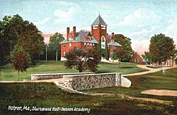
Agriculture was the principal occupation, with hay the chief crop. In addition, the town had fine orchards. The outlet of Marshall Pond, the largest body of water, provided power for mills. There was a sawmill, shingle mill, pail factory, blacksmith shop and shoe shop. In 1804, Deacon William Barrows, Jr. was instrumental in founding Hebron Academy. The town would be crossed by the Rumford Falls and Buckfield Railroad. [5] The Western Maine Sanatorium opened at Hebron in 1904, the first of its kind in the state. It treated tuberculosis patients with rest, fresh air and a healthy diet. Taken over by the state in 1915, it closed in 1959.

Geography

According to the United States Census Bureau, the town has a total area of 22.54 square miles (58.38 km2), of which 22.41 square miles (58.04 km2) is land and 0.13 square miles (0.34 km2) is water. [1] Hebron is drained by Cobb Brook, Cushman Brook, Bicknell Brook and Allen Brook.

The town is crossed by Maine State Route 119. It borders the towns of Buckfield to the north, Oxford to the south, Paris to the west, and Turner and Minot to the east.

Hebron is known for the Rubellite Tourmaline, found on Mt. Rubellite in Hebron Center.

Demographics

Historical population
CensusPop.Note
1800 981
1810 1,21123.4%
1820 1,72742.6%
1830 915−47.0%
1840 9453.3%
1850 839−11.2%
1860 8956.7%
1870 744−16.9%
1880 601−19.2%
1890 600−0.2%
1900 494−17.7%
1910 60322.1%
1920 6528.1%
1930 79121.3%
1940 678−14.3%
1950 82922.3%
1960 465−43.9%
1970 53214.4%
1980 66525.0%
1990 87832.0%
2000 1,05319.9%
2010 1,41634.5%
2020 1,223−13.6%
U.S. Decennial Census [6]
Sturtevant Home in 1907 Sturtevant Home, Hebron Academy, ME.jpg
Sturtevant Home in 1907

2010 census

As of the census [7] of 2010, there were 1,416 people, 449 households, and 343 families living in the town. The population density was 63.2 inhabitants per square mile (24.4/km2). There were 483 housing units at an average density of 21.6 per square mile (8.3/km2). The racial makeup of the town was 93.9% White, 1.1% African American, 0.3% Native American, 3.5% Asian, and 1.3% from two or more races. Hispanic or Latino of any race were 1.6% of the population.

There were 449 households, of which 38.1% had children under the age of 18 living with them, 59.5% were married couples living together, 9.6% had a female householder with no husband present, 7.3% had a male householder with no wife present, and 23.6% were non-families. 15.6% of all households were made up of individuals, and 3.5% had someone living alone who was 65 years of age or older. The average household size was 2.76 and the average family size was 3.05.

The median age in the town was 33.4 years. 29.8% of residents were under the age of 18; 10.8% were between the ages of 18 and 24; 24.2% were from 25 to 44; 28.4% were from 45 to 64; and 7.1% were 65 years of age or older. The gender makeup of the town was 52.6% male and 47.4% female.

2000 census

As of the census [8] of 2000, there were 1,053 people, 389 households, and 296 families living in the town. The population density was 47.0 inhabitants per square mile (18.1/km2). There were 410 housing units at an average density of 18.3 per square mile (7.1/km2). The racial makeup of the town was 97.82% White, 0.09% African American, 0.19% Native American, 0.57% Asian, 0.19% from other races, and 1.14% from two or more races. Hispanic or Latino of any race were 0.76% of the population.

There were 389 households, out of which 41.4% had children under the age of 18 living with them, 63.0% were married couples living together, 6.7% had a female householder with no husband present, and 23.7% were non-families. 18.8% of all households were made up of individuals, and 5.7% had someone living alone who was 65 years of age or older. The average household size was 2.71 and the average family size was 3.07.

Mountain View Cottage, c. 1905 Mountain View Cottage, Hebron, ME.jpg
Mountain View Cottage, c. 1905

In the town, the population was spread out, with 27.4% under the age of 18, 7.5% from 18 to 24, 31.7% from 25 to 44, 26.5% from 45 to 64, and 6.9% who were 65 years of age or older. The median age was 37 years. For every 100 females, there were 103.3 males. For every 100 females age 18 and over, there were 101.3 males.

The median income for a household in the town was $45,417, and the median income for a family was $47,292. Males had a median income of $30,529 versus $22,900 for females. The per capita income for the town was $19,086. About 3.0% of families and 4.6% of the population were below the poverty line, including 7.1% of those under age 18 and 2.9% of those age 65 or over.

Notable people

Related Research Articles

<span class="mw-page-title-main">Minot, Maine</span> Town in the state of Maine, United States

Minot is a town in Androscoggin County, Maine, United States. The population was 2,766 at the 2020 census. The town includes the villages of West Minot and Minot Center. It is part of both the Lewiston-Auburn, Maine metropolitan statistical area and the Lewiston-Auburn, Maine metropolitan New England city and town area.

<span class="mw-page-title-main">Turner, Maine</span> Town in the state of Maine, United States

Turner is a town in Androscoggin County, Maine, United States. The population was 5,817 at the 2020 census. The town includes the villages of Turner, Turner Center and North Turner. The town is part of the Lewiston-Auburn, Maine Metropolitan New England City and Town Area.

<span class="mw-page-title-main">Baldwin, Maine</span> Town in the state of Maine, United States

Baldwin is a town in Cumberland County, Maine, United States. The population was 1,520 at the 2020 census. It is part of the Portland–South Portland–Biddeford, Maine, metropolitan statistical area.

<span class="mw-page-title-main">Sebago, Maine</span> Town in Maine, United States

Sebago is a town in Cumberland County, Maine, United States. The population was 1,911 at the 2020 census. It is part of the Portland–South Portland–Biddeford, Maine metropolitan statistical area.

<span class="mw-page-title-main">Carthage, Maine</span> Town in the state of Maine, United States

Carthage is a town in Franklin County, Maine, United States. The population was 509 at the 2020 census.

<span class="mw-page-title-main">Brooklin, Maine</span> Town in the state of Maine, United States

Brooklin is a town in Hancock County, Maine, United States. The population was 827 at the 2020 census.

<span class="mw-page-title-main">Rome, Maine</span> Town in the state of Maine, United States

Rome is a town in Kennebec County, Maine, United States. The population was 1,148 at the 2020 census. It is part of the Belgrade Lakes resort area, and is included in the Augusta, Maine, micropolitan New England City and Town Area.

<span class="mw-page-title-main">Buckfield, Maine</span> Town in Maine, United States

Buckfield is a town in Oxford County, Maine, United States. Buckfield is included in the Lewiston-Auburn, Maine metropolitan New England City and Town Area. It is a member of Regional School Unit 10 along with nearby Hartford and Sumner. The town had a population of 1,983 as of the 2020 census.

<span class="mw-page-title-main">Canton, Maine</span> Town in the state of Maine, United States

Canton is a town in Oxford County, Maine, United States. The population was 1,125 at the 2020 census. Located beside Lake Anasagunticook, Canton is a summer recreational area.

<span class="mw-page-title-main">Sumner, Maine</span> Town in the state of Maine, United States

Sumner is a town in Oxford County, Maine, United States. Sumner is included in the Lewiston-Auburn, Maine metropolitan New England city and town area. The population was 994 at the 2020 census. The town includes the villages of West Sumner and East Sumner.

Sweden is a town in Oxford County, Maine, United States. The population was 406 at the 2020 census. Set among hills, forests and ponds, Sweden includes the village of East Sweden.

<span class="mw-page-title-main">Bowdoin, Maine</span> Town in the state of Maine, United States

Bowdoin is a town in Sagadahoc County, Maine, United States. The population was 3,136 at the 2020 census. Bowdoin is 31 land miles north of Portland, and 21 land miles south of Augusta.

<span class="mw-page-title-main">Solon, Maine</span> Town in the state of Maine, United States

Solon is a town in Somerset County, Maine, United States. The population was 978 at the 2020 census.

<span class="mw-page-title-main">Waldo, Maine</span> Town in the state of Maine, United States

Waldo is a town in Waldo County, Maine, United States. The population was 795 at the 2020 census. It is the home town of Heather Hemmens, who is known for her role on Hellcats.

<span class="mw-page-title-main">Limerick, Maine</span> Town in Maine, United States

Limerick is a town in York County, Maine, United States. It is part of the Portland–South Portland–Biddeford, Maine metropolitan statistical area. The population was 3,188 at the 2020 census.

<span class="mw-page-title-main">Dexter, Maine</span> Town in the state of Maine, United States

Dexter is a town in Penobscot County, Maine, United States. The population was 3,803 at the 2020 census. It is part of the Bangor metropolitan statistical area. Dexter Regional High School, which serves Dexter as well as other nearby small towns, is located in the town.

<span class="mw-page-title-main">Dixfield, Maine</span> Town in the state of Maine, United States

Dixfield is a town in Oxford County, Maine, United States. The population was 2,253 at the 2020 census. The town motto of Dixfield is "The Only One", because it is the only town in the world to claim that name. Dr. Elijeh Dix, a substantial landowner in the area, bought the town which bears his name.

<span class="mw-page-title-main">Oxford, Maine</span> Town in the state of Maine, United States

Oxford is a town in Oxford County, Maine, United States. The population was 4,229 at the 2020 census. Oxford is home to the Oxford Plains Speedway, Kamp Kohut, the annual Oxford County Fair, and Oxford Casino. The town includes the village of Welchville.

<span class="mw-page-title-main">Anson, Maine</span> Town in the state of Maine, United States

Anson is a town in Somerset County, Maine, United States. The population was 2,291 at the time of the 2020 census. It includes the villages of Anson and North Anson.

<span class="mw-page-title-main">Bingham, Maine</span> Town in the state of Maine, United States

Bingham is a town in Somerset County, Maine, United States. The population was 866 at the 2020 census. Bingham is a historic town located beside the Kennebec River.

References

  1. 1 2 "US Gazetteer files 2010". United States Census Bureau . Retrieved December 16, 2012.
  2. "Census - Geography Profile: Hebron town, Oxford County, Maine" . Retrieved January 20, 2022.
  3. Whitman, Mildred I. (1991). Along the roads to Sodom (2nd printing ed.). Buckfield, Maine: Mildred I. Whitman. p. 
    Moses Snell Homestead Moses Snell Homestead.jpg
    Moses Snell Homestead
    . Retrieved December 2, 2018.
  4. Coolidge, Austin J.; John B. Mansfield (1859). A History and Description of New England. Boston, Massachusetts: A.J. Coolidge. pp.  155–156. coolidge mansfield history description new england 1859.
  5. Varney, George J. (1886), Gazetteer of the state of Maine. Hebron, Boston: Russell
  6. "Census of Population and Housing". Census.gov. Retrieved June 4, 2015.
  7. "U.S. Census website". United States Census Bureau . Retrieved December 16, 2012.
  8. "U.S. Census website". United States Census Bureau . Retrieved January 31, 2008.

44°11′53″N70°24′23″W / 44.19806°N 70.40639°W / 44.19806; -70.40639