Gorham is a census-designated place (CDP) and the main village in the town of Gorham in Coos County, New Hampshire, United States. The population of the CDP was 1,851 at the 2020 census, out of 2,698 people in the entire town of Gorham.
Brownville Junction is a census-designated place (CDP) in the town of Brownville, Piscataquis County, Maine, United States. It is west-central part of the town, on the west side of the Pleasant River, a south-flowing tributary of the Piscataquis River and part of the Penobscot River watershed. Maine State Route 11 passes through the community, leading south 3 miles (5 km) to Brownville village and 7 miles (11 km) to Milo, and northeast 31 miles (50 km) to Millinocket.

Little Falls is a census-designated place (CDP) in the town of Gorham in Cumberland County, Maine, United States. The population of the CDP was 708 at the 2010 census. Prior to 2010, Little Falls was part of the Little Falls-South Windham census-designated place.

Blaine is a census-designated place (CDP) comprising the main village within the town of Blaine in Aroostook County, Maine, United States. The population of the CDP was 301 at the 2010 census, out of a population of 726 for the entire town. Prior to 2010, the village was part of the Mars Hill-Blaine CDP.
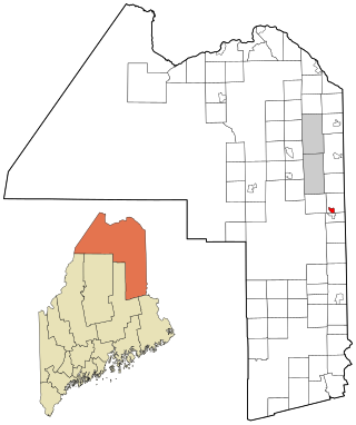
Mars Hill is a census-designated place (CDP) comprising the main village within the town of Mars Hill in Aroostook County, Maine, United States. The population of the CDP was 980 at the 2010 census, out of a population of 1,493 for the entire town. Prior to 2010, the village was part of the Mars Hill-Blaine CDP.
Winter Harbor is a census-designated place (CDP) in the town of Winter Harbor in Hancock County, Maine, United States. The CDP population was 426 at the 2010 census, out of 516 people in the town as a whole.

Damariscotta is a census-designated place (CDP) comprising the main village of the town of Damariscotta in Lincoln County, Maine, United States. The population was 1,142 at the 2010 census, out of 2,218 in the entire town. In the 2000 census, the village was part of the Damariscotta-Newcastle CDP.
Newcastle is a census-designated place (CDP) comprising the main village of the town of Newcastle in Lincoln County, Maine, United States. The population was 667 at the 2010 census, out of 1,752 in the entire town. In the 2000 census, the village was part of the Damariscotta-Newcastle CDP.
Randolph is the primary village and a census-designated place (CDP) in the town of Randolph, Orange County, Vermont, United States. As of the 2020 census, it had a population of 2,083, out of 4,774 in the entire town of Randolph.

Waldoboro is a census-designated place (CDP) comprising the central village in the town of Waldoboro in Lincoln County, Maine, United States. The population was 1,300 at the 2020 census, out of 5,075 people in the entire town of Waldoboro.

Wiscasset is a census-designated place (CDP) comprising the primary settlement in the town of Wiscasset in Lincoln County, Maine, United States. The population was 1,232 at the 2020 census, out of 3,732 people in the entire town. Wiscasset is the county seat of Lincoln County.
Alfred is a census-designated place (CDP) and the primary village in the town of Alfred, York County, Maine, United States. It is in central York County and the center of the town of Alfred, 4 miles (6 km) northeast of Sanford and 13 miles (21 km) west of Biddeford. U.S. Route 202 passes through the village, leading northeast 23 miles (37 km) to Gorham and southwest through Sanford 20 miles (32 km) to Rochester, New Hampshire. Maine State Route 4 leads south 13 miles (21 km) to North Berwick and leads north out of town with US 202. State Route 111 leads east from Alfred to Biddeford.
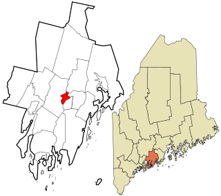
Lisbon is a census-designated place (CDP) in the town of Lisbon, Androscoggin County, Maine, United States. It is one of the two main villages in the town, the other being Lisbon Falls. Lisbon village is in the western half of the town of Lisbon and is located on the Sabattus River, a south-flowing tributary of the Androscoggin River. Maine State Route 196 passes through the village, leading southeast 3 miles (5 km) to Lisbon Falls and northwest 7 miles (11 km) to Lewiston. The small village of Lisbon Center is in the southeast part of the CDP.
Island Falls is a census-designated place (CDP) and the primary village in the town of Island Falls, Aroostook County, Maine, United States. It is in the northwest part of the town, situated on the West Branch Mattawamkeag River, part of the Penobscot River watershed. U.S. Route 2 passes through the village, leading northeast 27 miles (43 km) to Houlton and south 38 miles (61 km) to Mattawamkeag. Maine State Route 159 has its eastern terminus at U.S. 2 in the center of Island Falls and leads west 10 miles (16 km) to Patten. Interstate 95 passes just west of the village of Island Falls, with access from Exit 276 ; I-95 leads northeast to Houlton and southwest 92 miles (148 km) to Bangor.
Rangeley is a census-designated place (CDP) and the primary village in the town of Rangeley, Franklin County, Maine, United States. It is in the southeast corner of the town, at the northeast end of Rangeley Lake. Maine State Route 4 runs through the village, leading southeast 40 miles (64 km) to Farmington and west 7 miles (11 km) to Oquossoc village in the western part of the town of Rangeley. State Route 16 joins Route 4 in Rangeley village, running west with it to Oquossoc but leading northeast 19 miles (31 km) to Stratton.
Corinna is a census-designated place (CDP) and the primary village in the town of Corinna, Penobscot County, Maine, United States. It is in the southern part of the town, on both sides of the East Branch Sebasticook River, part of the Kennebec River watershed.
Mattawamkeag is a census-designated place (CDP) and the primary village in the town of Mattawamkeag, Penobscot County, Maine, United States. It is in the southwestern corner of the town, where the Mattawamkeag River joins the Penobscot. The community is bordered to the south by the town of Winn and to the west, across the Penobscot, by the town of Woodville.
Patten is a census-designated place (CDP) and the primary village in the town of Patten, Penobscot County, Maine, United States. It is in the northeastern part of the town, mostly on the north side of Fish Stream, an eastward-flowing tributary of the West Branch Mattawamkeag River and part of the Penobscot River watershed.
Cornish is a census-designated place (CDP) and the primary village in the town of Cornish, York County, Maine, United States. It is on the northern border of York County, on the south side of the Ossipee River where it joins the Saco. To the north, across the Ossipee, is the town of Hiram in Oxford County, and to the east, across the Saco, is the town of Baldwin in Cumberland County.
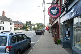
South Berwick is a census-designated place (CDP) and the primary village in the town of South Berwick, York County, Maine, United States. It is in southwestern York County, in the northwestern corner of the town of South Berwick. It is bordered to the north by the town of Berwick, and to the southwest, across the Salmon Falls River, by the town of Rollinsford, New Hampshire.


