South Paris, Maine

Last updated

South Paris
CDP
View of Market Square, South Paris, ME.jpg
Market Square in 1907
USA Maine location map.svg
Red pog.svg
South Paris
Location in Maine
Coordinates: 44°13′18″N70°30′53″W / 44.22167°N 70.51472°W / 44.22167; -70.51472
Country United States
State Maine
County Oxford
Area
[1]
  Total3.95 sq mi (10.23 km2)
  Land3.88 sq mi (10.04 km2)
  Water0.07 sq mi (0.19 km2)
Elevation
387 ft (118 m)
Population
 (2020)
  Total2,183
  Density563.21/sq mi (217.46/km2)
Demonym South Parisian
Time zone UTC-5 (Eastern (EST))
  Summer (DST) UTC-4 (EDT)
ZIP code
04281
Area code 207
FIPS code 23-71780
GNIS feature ID0575877

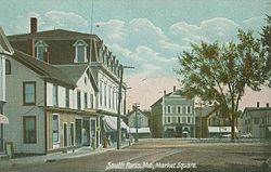
South Paris is a census-designated place (CDP) located within the town of Paris in Oxford County, Maine, United States. South Paris is included in the Lewiston-Auburn, Maine metropolitan New England city and town area.The population was 2,237 at the 2000 census. While the CDP refers only to the densely settled area in the southern part of the town of Paris, the entire town, outside of Paris Hill, is located within the South Paris ZIP code, resulting in many residents referring to the entire town as South Paris.

Contents

History

During the 19th-century, the Little Androscoggin River provided water power to operate mills in South Paris, and the village grew up around them. [2] The opening of the Atlantic and St. Lawrence Railroad on June 8, 1850 further spurred development of the small mill town. [3] In the 1890s, the Oxford County Courthouse moved from Paris Hill to be near the Grand Trunk Railway station. [4] Much of the manufacturing and industry faded with the Great Depression, but South Paris remains the commercial section of Paris, and retains much of its Victorian era architecture. Oxford Hills Comprehensive High School, the regional high school, was founded in South Paris in 1961. [5] Actress Reta Shaw was born in South Paris in 1912.

Geography

South Paris is located at 44°13′18″N70°30′53″W / 44.22167°N 70.51472°W / 44.22167; -70.51472 (44.221609, -70.514603). [6]

According to the United States Census Bureau, the CDP has a total area of 4.0 square miles (10.2 km2), of which 3.9 square miles (10.0 km2) is land and 0.1 square mile (0.2 km2) (2.03%) is water. South Paris is drained by the Little Androscoggin River.

The town is crossed by Maine State Route 26, 117, 118 and 119. The town has a small park, Moore Park, with a new, fenced in playground for children to play in. Moore Park no longer has a water fountain, but there is a monument in the center with a gazebo to one side for public events.

Demographics

Historical population
CensusPop.Note
2020 2,183
U.S. Decennial Census [7]
Paris Public Library, designed by John Calvin Stevens Public Library, South Paris, ME.jpg
Paris Public Library, designed by John Calvin Stevens

As of the census [8] of 2008, there were 2,237 people, 972 households, and 536 families residing in the CDP. The population density was 577.1 inhabitants per square mile (222.8/km2). There were 1,052 housing units at an average density of 271.4 per square mile (104.8/km2). The racial makeup of the CDP was 97.32% White, 0.36% African American, 0.18% Native American, 1.34% Asian, 0.04% Pacific Islander, 0.04% from other races, and 0.72% from two or more races. Hispanic or Latino of any race were 0.49% of the population.

There were 972 households, out of which 25.0% had children under the age of 18 living with them, 40.5% were married couples living together, 11.1% had a female householder with no husband present, and 44.8% were non-families. 36.9% of all households were made up of individuals, and 17.3% had someone living alone who was 65 years of age or older. The average household size was 2.16 and the average family size was 2.84.

Deering Memorial Church, designed by Sidney Badgley Deering Memorial Church, South Paris, ME.jpg
Deering Memorial Church, designed by Sidney Badgley

In the CDP, the population was spread out, with 20.4% under the age of 18, 9.9% from 18 to 24, 27.1% from 25 to 44, 21.4% from 45 to 64, and 21.2% who were 65 years of age or older. The median age was 39 years. For every 100 females, there were 90.4 males. For every 100 females age 18 and over, there were 86.3 males.

The median income for a household in the CDP was $27,569, and the median income for a family was $42,105. Males had a median income of $28,906 versus $19,960 for females. The per capita income for the CDP was $15,486. About 4.4% of families and 11.4% of the population were below the poverty line, including 8.7% of those under age 18 and 15.2% of those age 65 or over.

Notable people

Sites of interest

Related Research Articles

<span class="mw-page-title-main">Lisbon, Maine</span> Town in the state of Maine, United States

Lisbon is a town in Androscoggin County, Maine, United States. The population was 9,711 at the 2020 census. It is included in both the Lewiston-Auburn, Maine metropolitan statistical area and the Lewiston–Auburn, Maine Metropolitan New England city and town area. The town of Lisbon includes the villages of Lisbon and Lisbon Falls.

<span class="mw-page-title-main">Lisbon Falls, Maine</span> Census-designated place in Maine, United States

Lisbon Falls is a census-designated place (CDP) in the town of Lisbon, located in Androscoggin County, Maine, United States. The population of Lisbon Falls was 4,100 at the 2010 census. It is included in both the Lewiston-Auburn, Maine metropolitan statistical area and the Lewiston-Auburn, Maine, Metropolitan New England city and town area.

<span class="mw-page-title-main">Minot, Maine</span> Town in the state of Maine, United States

Minot is a town in Androscoggin County, Maine, United States. The population was 2,766 at the 2020 census. The town includes the villages of West Minot and Minot Center. It is part of both the Lewiston-Auburn, Maine metropolitan statistical area and the Lewiston-Auburn, Maine metropolitan New England city and town area.

<span class="mw-page-title-main">Carthage, Maine</span> Town in the state of Maine, United States

Carthage is a town in Franklin County, Maine, United States. The population was 509 at the 2020 census.

Chisholm is a census-designated place (CDP) in the town of Jay in Franklin County, Maine, United States. The population was 1,380 at the 2010 census. It is an industrial village named for Hugh J. Chisholm, who built the Otis Falls Pulp & Paper Company here in 1888 to use Androscoggin River water power.

<span class="mw-page-title-main">Wayne, Maine</span> Town in the state of Maine, United States

Wayne is a town in Kennebec County, Maine, United States. Wayne is included in the Lewiston-Auburn, Maine metropolitan New England city and town area. The population was 1,129 at the 2020 census. The town was named after Revolutionary War General Anthony Wayne. During the summer, Wayne is home to Camp Androscoggin. A popular recreation spot in central Maine, Wayne is part of the Winthrop Lakes Region. The town is included in the Augusta, Maine micropolitan New England City and Town Area. and included in the Lewiston-Auburn, Maine metropolitan New England city and town area.

<span class="mw-page-title-main">Buckfield, Maine</span> Town in Maine, United States

Buckfield is a town in Oxford County, Maine, United States. Buckfield is included in the Lewiston-Auburn, Maine metropolitan New England City and Town Area. It is a member of Regional School Unit 10 along with nearby Hartford and Sumner. The town had a population of 1,983 as of the 2020 census.

<span class="mw-page-title-main">Canton, Maine</span> Town in the state of Maine, United States

Canton is a town in Oxford County, Maine, United States. Canton is included in the Lewiston-Auburn, Maine metropolitan New England city and town area. The population was 1,125 at the 2020 census. Located beside Lake Anasagunticook, Canton is a summer recreational area.

<span class="mw-page-title-main">Paris, Maine</span> Town in Maine, United States

Paris is a town in and the county seat of Oxford County, Maine, United States. Paris is included in the Lewiston-Auburn, Maine metropolitan New England City and town area. The population was 5,179 at the 2020 census. The census-designated place of South Paris is located within the town. Because the U.S. Post Office refers to the entire town as South Paris, the town as a whole is commonly referred to as South Paris. The main exception is the area known as Paris Hill, which is a scenic historic district popular with tourists. On May 30, 2019, the town declared itself to be a second amendment sanctuary.

<span class="mw-page-title-main">Roxbury, Maine</span> Town in the state of Maine, United States

Roxbury is a town in Oxford County, Maine, United States. The population was 361 at the 2020 census. Ellis Pond is popular with recreational fishermen.

<span class="mw-page-title-main">Bowdoin, Maine</span> Town in the state of Maine, United States

Bowdoin is a town in Sagadahoc County, Maine, United States. Bowdoin is included in the Lewiston-Auburn, Maine metropolitan New England city and town area. The population was 3,136 at the 2020 census. Bowdoin is 31 land miles north of Portland, and 21 land miles south of Augusta.

<span class="mw-page-title-main">Errol, New Hampshire</span> Town in New Hampshire, United States

Errol is a town in Coös County, New Hampshire, United States. The population was 298 at the 2020 census. It is located north of the White Mountains along Route 16 at its intersection of Route 26. It has a municipal airport with a single, unpaved runway.

Gorham is a census-designated place (CDP) and the main village in the town of Gorham in Coos County, New Hampshire, United States. The population of the CDP was 1,851 at the 2020 census, out of 2,698 people in the entire town of Gorham.

<span class="mw-page-title-main">Livermore Falls (CDP), Maine</span> Census-designated place in Maine, United States

Livermore Falls is a census-designated place (CDP) in the town of Livermore Falls in Androscoggin County, Maine, United States. The population of the CDP was 1,594 at the 2010 census, out of a population of 3,187 within the full town.

<span class="mw-page-title-main">Livermore Falls, Maine</span> Town in the state of Maine, United States

Livermore Falls is a town in Androscoggin County, Maine, United States. The population was 3,060 at the 2020 census. It is included in both the Lewiston-Auburn, Maine Metropolitan Statistical Area and the Lewiston-Auburn, Maine Metropolitan New England City and Town Area. High school students in Livermore Falls attend Spruce Mountain High School.

<span class="mw-page-title-main">Mechanic Falls (CDP), Maine</span> Census-designated place in Maine, United States

Mechanic Falls is a census-designated place (CDP) in the town of Mechanic Falls in Androscoggin County, Maine, United States. The population of the CDP was 2,237 at the 2010 census, out of a total town population of 3,031.

<span class="mw-page-title-main">Mechanic Falls, Maine</span> Town in the state of Maine, United States

Mechanic Falls is a town in Androscoggin County, Maine, United States. The population was 3,107 at the 2020 census. It is included in both the Lewiston-Auburn, Maine metropolitan statistical area and the Lewiston-Auburn, Maine metropolitan New England city and town area.

<span class="mw-page-title-main">Mexico, Maine</span> Town in the state of Maine, United States

Mexico is near Rumford in a town in Oxford County, Maine, United States. Mexico is included in the Lewiston-Auburn, Maine metropolitan New England city and town area. The population was 2,756 at the 2020 census. Mexico is a small mill town for the papermaking industry.

<span class="mw-page-title-main">Oxford, Maine</span> Town in the state of Maine, United States

Oxford is a town in Oxford County, Maine, United States. Oxford is included in the Lewiston-Auburn, Maine metropolitan New England city and town area. The population was 4,229 at the 2020 census. Oxford is home to the Oxford Plains Speedway, Kamp Kohut, the annual Oxford County Fair, and Oxford Casino. The town includes the village of Welchville.

<span class="mw-page-title-main">Topsham, Maine</span> Town in the state of Maine, United States

Topsham is a town in Sagadahoc County, Maine, United States. Topsham was included in the Lewiston-Auburn, Maine metropolitan New England city and town area. The population was 9,560 at the 2020 census. It is part of the Portland–South Portland–Biddeford, Maine metropolitan statistical area. The town is home to the annual Topsham Fair.

References

  1. "2020 U.S. Gazetteer Files". United States Census Bureau. Retrieved April 8, 2022.
  2. Coolidge, Austin J.; John B. Mansfield (1859). A History and Description of New England. Boston, Massachusetts: A.J. Coolidge. pp.  246–247. coolidge mansfield history description new england 1859.
  3. Varney, George J. (1886), Gazetteer of the state of Maine. Paris, Boston: Russell
  4. History of Paris Hill as Oxford County Seat Archived 2007-10-16 at the Wayback Machine
  5. Maine.gov -- Paris, Maine
  6. "US Gazetteer files: 2010, 2006, and 1990". United States Census Bureau. February 12, 2011. Retrieved April 23, 2011.
  7. "Census of Population and Housing". Census.gov. Retrieved June 4, 2016.
  8. "U.S. Census website". United States Census Bureau . Retrieved January 31, 2008.