Porter, Maine

Last updated
Porter, Maine
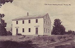
Old Porter Meeting House, Porter, ME.jpg
Old Porter Meeting House (built 1828), c.1922
USA Maine location map.svg
Red pog.svg
Porter, Maine
Location within the state of Maine
Coordinates: 43°50′2″N70°55′51″W / 43.83389°N 70.93083°W / 43.83389; -70.93083
Country United States
State Maine
County Oxford
Incorporated1807
Area
[1]
  Total32.87 sq mi (85.13 km2)
  Land31.50 sq mi (81.58 km2)
  Water1.37 sq mi (3.55 km2)
Elevation
466 ft (142 m)
Population
 (2020)
  Total1,600
  Density51/sq mi (19.6/km2)
Time zone UTC-5 (Eastern (EST))
  Summer (DST) UTC-4 (EDT)
ZIP code
04068
Area code 207
FIPS code 23-60405
GNIS feature ID0582682

Porter is a town in Oxford County, Maine, United States. It is included in the Portland-South Portland-Biddeford, Maine metropolitan New England City and Town Area. Porter includes Porter village and part of Kezar Falls. The population was 1,600 at the 2020 census. [2]

Contents

History

The land was once territory of Pequawket, the Abenaki village at what is now Fryeburg. It was purchased from the Massachusetts General Court in September 1795 by Dr. Aaron Porter of Biddeford and others. Terms of the grant offered 100 acres (40 ha) to each man who settled before January 1, 1784. First called Portersfield Plantation, it was incorporated as a town on February 20, 1807, named for its principal proprietor. Land was set off to Brownfield in 1831, 1832 and 1855. [3]

Although farmers found the town's surface uneven, the hillsides offered excellent pasturage for cattle. Porter became noted for its orchards. Outlets of ponds provided sites for mills, with the best water power on the Ossipee River at Kezar Falls, where part of the village lies in Parsonsfield. The town had numerous sawmills, a gristmill, furniture factory, bobbin factory and a boot and shoe factory. In 1870, the population was 1,104. [4]

Geography

According to the United States Census Bureau, the town has a total area of 32.87 square miles (85.13 km2), of which 31.50 square miles (81.58 km2) is land and 1.37 square miles (3.55 km2) is water. [1] Porter is drained by the Ossipee River.

The town is crossed by state routes 25 and 160. Porter borders the towns of Eaton and Freedom, New Hampshire to the west, Brownfield to the north, Hiram to the east, and Parsonsfield to the south.

Demographics

Historical population
CensusPop.Note
1810 292
1820 48766.8%
1830 84172.7%
1840 1,13334.7%
1850 1,2086.6%
1860 1,2402.6%
1870 1,104−11.0%
1880 1,095−0.8%
1890 1,015−7.3%
1900 886−12.7%
1910 864−2.5%
1920 820−5.1%
1930 8837.7%
1940 8921.0%
1950 1,05217.9%
1960 975−7.3%
1970 1,11514.4%
1980 1,2229.6%
1990 1,3016.5%
2000 1,43810.5%
2010 1,4984.2%
2020 1,6006.8%
U.S. Decennial Census [5]

2010 census

As of the census [6] of 2010, there were 1,498 people, 621 households, and 416 families living in the town. The population density was 47.6 inhabitants per square mile (18.4/km2). There were 816 housing units at an average density of 25.9 per square mile (10.0/km2). The racial makeup of the town was 97.2% White, 0.8% African American, 0.2% Native American, 0.5% Asian, 0.2% Pacific Islander, 0.1% from other races, and 1.0% from two or more races. Hispanic or Latino of any race were 0.6% of the population.

There were 621 households, of which 28.0% had children under the age of 18 living with them, 49.3% were married couples living together, 11.3% had a female householder with no husband present, 6.4% had a male householder with no wife present, and 33.0% were non-families. 25.8% of all households were made up of individuals, and 9.7% had someone living alone who was 65 years of age or older. The average household size was 2.41 and the average family size was 2.83.

The median age in the town was 44.4 years. 20.2% of residents were under the age of 18; 8.1% were between the ages of 18 and 24; 22.6% were from 25 to 44; 33.6% were from 45 to 64; and 15.5% were 65 years of age or older. The gender makeup of the town was 50.5% male and 49.5% female.

2000 census

As of the census [7] of 2000, there were 1,438 people, 562 households, and 1,410 families living in the town. The population density was 45.7 inhabitants per square mile (17.6/km2). There were 742 housing units at an average density of 23.6 per square mile (9.1/km2). The racial makeup of the town was 97.01% White, 0.35% African American, 0.49% Native American, 0.35% Asian, 0.21% from other races, and 1.60% from two or more races. Hispanic or Latino of any race were 0.70% of the population.

There were 562 households, out of which 31.9% had children under the age of 18 living with them, 54.6% were married couples living together, 12.6% had a female householder with no husband present, and 27.0% were non-families. 21.5% of all households were made up of individuals, and 8.0% had someone living alone who was 65 years of age or older. The average household size was 2.56 and the average family size was 2.92.

In the town, the population was spread out, with 25.9% under the age of 18, 8.6% from 18 to 24, 28.2% from 25 to 44, 24.0% from 45 to 64, and 13.4% who were 65 years of age or older. The median age was 38 years. For every 100 females, there were 96.2 males. For every 100 females age 18 and over, there were 93.8 males.

The median income for a household in the town was $33,802, and the median income for a family was $37,552. Males had a median income of $25,739 versus $23,000 for females. The per capita income for the town was $15,271. About 12.9% of families and 14.8% of the population were below the poverty line, including 20.3% of those under age 18 and 11.0% of those age 65 or over.
Local schools

Notable people

Sites of interest

Related Research Articles

<span class="mw-page-title-main">York County, Maine</span> County in Maine, United States

York County is the southwesternmost county in the U.S. state of Maine, along the state of New Hampshire's eastern border. It is divided from Strafford County, New Hampshire, by the Salmon Falls River, and the connected tidal estuary—the Piscataqua River. York County was permanently established in 1639. It is the state's oldest county and one of the oldest in the United States. Several of Maine's earliest colonial settlements are found in the county. As of the 2020 census, its population was 211,972, making it Maine's second-most populous county. Its county seat is Alfred. York County is part of the Portland–South Portland, Maine Metropolitan Statistical Area.

<span class="mw-page-title-main">Baldwin, Maine</span> Town in the state of Maine, United States

Baldwin is a town in Cumberland County, Maine, United States. The population was 1,520 at the 2020 census. It is part of the Portland–South Portland–Biddeford, Maine, metropolitan statistical area.

<span class="mw-page-title-main">West Gardiner, Maine</span> Town in the state of Maine, United States

West Gardiner is a town in Kennebec County, Maine, United States. The population was 3,671 at the 2020 census. West Gardiner is included in the Augusta, Maine micropolitan New England City and Town Area.

<span class="mw-page-title-main">Hanover, Maine</span> Town in the state of Maine, United States

Hanover is a town in Oxford County, Maine, United States. The population was 286 at the 2020 census. The town is a popular vacation and recreation area.

<span class="mw-page-title-main">Hiram, Maine</span> Town in the state of Maine, United States

Hiram is a town in Oxford County, Maine, United States. The population was 1,609 at the 2020 census. It includes the villages of Hiram, East Hiram, South Hiram and Durgintown. Located among the rugged and unspoiled Western Maine Mountains, Hiram is part of the Portland-South Portland-Biddeford, Maine metropolitan New England city and town area.

<span class="mw-page-title-main">Lovell, Maine</span> Town in the state of Maine, United States

Lovell is a town in Oxford County, Maine, United States. The population was 1,104 at the 2020 census. Lovell is the site of Kezar Lake, a resort area.

Ripley is a town in Somerset County, Maine, United States. The community was named after Brigadier General Eleazer Wheelock Ripley of the War of 1812. The population was 484 at the 2020 census.

<span class="mw-page-title-main">Acton, Maine</span> Town in the state of Maine, United States

Acton is a town in York County, Maine, United States. The population was 2,671 at the 2020 census. It includes the villages of Acton, Miller Corner and South Acton. The town is home to the Acton Fairground, which holds the Acton Fair every late summer. It is part of the Portland–South Portland–Biddeford, Maine metropolitan statistical area.

<span class="mw-page-title-main">Cornish, Maine</span> Town in the state of Maine, United States

Cornish is a town in York County, Maine, United States. The population was 1,508 at the 2020 census. It is part of the Portland–South Portland–Biddeford, Maine metropolitan statistical area. The main village in town is the Cornish census-designated place. The village has a number of antique shops and restaurants near historic Thompson Park. Cornish is home to the first concrete bridge in North America.

Lake Arrowhead is a census-designated place (CDP) in the towns of Waterboro and Limerick in York County, Maine, United States. The population was 3,071 at the 2010 census. The CDP corresponds to the area covered by the Lake Arrowhead Community, a large subdivision begun in the 1960s which surrounds Lake Arrowhead, an artificial lake on the Little Ossipee River. The community is part of the Portland–South Portland–Biddeford, Maine Metropolitan Statistical Area.

<span class="mw-page-title-main">Limington, Maine</span> Town in the state of Maine, United States

Limington is a town in York County, Maine, United States. The population was 3,892 at the 2020 census. Limington is a tourist destination with historic architecture. It is part of the Portland–South Portland–Biddeford, Maine metropolitan statistical area.

<span class="mw-page-title-main">Newfield, Maine</span> Town in the state of Maine, United States

Newfield is a town in York County, Maine, United States. The population was 1,648 at the 2020 census. The town is part of the Portland–South Portland–Biddeford metropolitan statistical area.

<span class="mw-page-title-main">Parsonsfield, Maine</span> Town in the state of Maine, United States

Parsonsfield is a town in York County, Maine, United States. The population was just 1,791 at the 2020 census. Parsonsfield includes the villages of Kezar Falls, Parsonsfield, and North, East and South Parsonsfield. It is part of the Portland–South Portland–Biddeford, Maine metropolitan statistical area.

<span class="mw-page-title-main">Shapleigh, Maine</span> Town in the state of Maine, United States

Shapleigh, pronounced "SHAP-lee", is a town in York County, Maine, United States which was incorporated as the state's 43rd town in 1785. The population was 2,921 at the 2020 census. Shapleigh is divided into the villages of North Shapleigh, Shapleigh Corner, Ross Corner and Emery Mills. It is part of the Portland–South Portland–Biddeford, Maine metropolitan statistical area.

<span class="mw-page-title-main">South Eliot, Maine</span> Census-designated place in Maine, United States

South Eliot is a census-designated place (CDP) in the town of Eliot in York County, Maine, United States. The population was 3,550 at the 2010 census. It is part of the Portland–South Portland–Biddeford, Maine Metropolitan Statistical Area.

<span class="mw-page-title-main">Waterboro, Maine</span> Town in Maine, United States

Waterboro is a town in York County, Maine, United States. The population was 7,936 at the 2020 census. It is part of the Portland–South Portland–Biddeford, Maine metropolitan statistical area.

<span class="mw-page-title-main">Effingham, New Hampshire</span> Town in New Hampshire, United States

Effingham is a town in Carroll County, New Hampshire, United States. At the 2020 census, the town population was 1,691, up from 1,465 at the 2010 census. Effingham includes the villages of Effingham Falls, Effingham, Center Effingham, and South Effingham. Pine River State Forest is in the south.

<span class="mw-page-title-main">Freedom, New Hampshire</span> Town in New Hampshire, United States

Freedom is a town located in Carroll County, New Hampshire, United States. The population was 1,689 at the 2020 census, up from 1,489 at the 2010 census. The town's eastern boundary runs along the Maine state border. Ossipee Lake, with a resort and camps, is in the southwest of the town.

<span class="mw-page-title-main">Wakefield, New Hampshire</span> Town in New Hampshire, United States

Wakefield is a town in Carroll County, New Hampshire, United States. The population was 5,201 at the 2020 census. The town includes the villages of Wakefield Corner, East Wakefield, North Wakefield, Sanbornville, Union, Woodman and Province Lake. Wakefield Corner, popular with tourists, is a picturesque hilltop village of antique buildings. The state of Maine is on the eastern border of Wakefield.

<span class="mw-page-title-main">Woodland, Aroostook County, Maine</span> Town in the state of Maine, United States

Woodland is a town in Aroostook County, Maine, United States. The population was 1,217 at the 2020 census. Because the state of Maine has a law stating that no two towns may share the same name, Woodland of Aroostook County and Woodland of Washington County found themselves before the Maine Supreme Judicial Court in the late 1990s. Because it was founded as a township first, Woodland of Aroostook County was allowed to keep its name and Woodland of Washington County was ordered by the court to choose a new name: Baileyville.

References

  1. 1 2 "US Gazetteer files 2010". United States Census Bureau . Retrieved 2012-12-16.
  2. "Census - Geography Profile: Porter town, Oxford County, Maine" . Retrieved January 20, 2022.
  3. Coolidge, Austin J.; John B. Mansfield (1859). A History and Description of New England. Boston, Massachusetts. pp. 265–267.
  4. George J. Varney, "History of Porter, Maine" (1886)
  5. "Census of Population and Housing". Census.gov. Retrieved June 4, 2015.
  6. "U.S. Census website". United States Census Bureau . Retrieved 2012-12-16.
  7. "U.S. Census website". United States Census Bureau . Retrieved 2008-01-31.

43°47′45″N70°55′57″W / 43.79583°N 70.93250°W / 43.79583; -70.93250