
Trout Lake Township is located in north central Minnesota in Itasca County, United States. It is bordered by the City of Coleraine to the west and north, City of Bovey on the north, an unorganized township on the east, and Blackberry Township to the south. Town government was adopted on March 6, 1894. The population was 1,056 at the 2020 census.

Lake Winnebago is a shallow freshwater lake in the north central United States, located in east central Wisconsin. At 137,700 acres, it is the largest lake entirely within the state, covering an area of about 30 miles by 10 miles with 88 miles of shoreline, an average depth of 15.5 feet, and a maximum depth of 21 feet. It has many shallow reefs along the west shore and a drop-off type shoreline on the east. There are several islands along the west shore.
Lake Attitash is a lake located on the border of Merrimac, Massachusetts and Amesbury, Massachusetts, and constitutes at least a portion of Amesbury's water supply.
Trickey Pond is a water body in the U.S. state of Maine. Its maximum depth is 55 feet (17 m). The lack of serious pollution in the area contributes to the pond's remarkably good water clarity. At most points in the pond, the entire depth can be seen.
Spy Pond, also known as Spie Pond in the 17th and 18th centuries, is a 103-acre (0.42 km2) kettle hole pond located near the heart of Arlington, Massachusetts, United States, adjacent to the Minuteman Bikeway.

Goose Pond is a 625-acre (2.5 km2) water body located in Grafton County in western New Hampshire, United States, in the towns of Canaan and Hanover. It is considered a great pond by the state of New Hampshire. The lake has 6.3 miles (10.1 km) of shoreline, and is approximately 3 miles (5 km) long by 0.5 miles (0.8 km) wide. All but the northernmost end of the pond is in the town of Canaan. The average depth of the pond is approximately 10 feet (3.0 m), with the deepest part approximately 35 feet (11 m). The lake is part of the Mascoma River watershed, flowing to the Connecticut River.

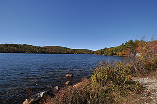
Great East Lake is an 1,825-acre (7.4 km2) water body located in Carroll County, New Hampshire, and York County, Maine, in the United States. The lake is shared by the towns of Wakefield, New Hampshire, and Acton, Maine, with 45% of its surface area in Acton and 55% in Wakefield. The lake is the farthest upstream of the five headwater lakes of the Salmon Falls River, a tributary of the Piscataqua River. Water from Great East Lake flows out its dam and through the 800-foot (240 m) Newichawannock Canal into Horn Pond, then into the Salmon Falls River below Horn Pond.
The Suncook Lakes are a pair of lakes located in Belknap County in central New Hampshire, United States, in the town of Barnstead. Upper Suncook Lake encompasses 402 acres (1.63 km2), while Lower Suncook Lake covers 295 acres (1.19 km2). The lakes are connected by a 1,000-foot-long (300 m) channel, spanned by a road bridge. A dam at the outlet of Lower Suncook Lake controls the water level of both lakes. The lakes are located along the Suncook River, a tributary of the Merrimack River. There are three islands on Lower Lake.

Otis Reservoir is a 1,085-acre (4 km2) reservoir located primarily in Otis, Massachusetts, United States. Small portions are also in Tolland, MA, and Blandford, MA. The lake is popular for boating, swimming, fishing, water skiing, snowmobiling, camping, and water-related recreation. Fish include bass, white perch, yellow perch, tiger muskies, catfish, and bluegills. The reservoir is stocked with trout by the Massachusetts Division of Fisheries & Wildlife.

Lake Lashaway is a 293-acre (1.19 km2) pond located near the East Brookfield and North Brookfield, Massachusetts town line. The Lake Lashaway Community Association’s website is www.LakeLashaway.org. The town line cuts the lake approximately in half. The lake lies just to the north of state Route 9 as it passes through East Brookfield.

Quaboag Pond is a 537-acre (2.17 km2) pond located a couple of miles south of and between East Brookfield and Brookfield, Massachusetts. The pond lies about two miles (3 km) south of state Route 9 as it passes through East Brookfield. Quaboag Pond was once named Podunk Pond.

Billington Sea is a 269-acre (1.09 km2) warm water pond located in Plymouth, Massachusetts. Morton Park lies on the pond's northern shore. The pond is fed by groundwater and cranberry bog outlets. The average depth is seven feet and the maximum depth is 11 feet (3.4 m). The pond provides the headwaters to Town Brook. Seymour Island is located in the center of the pond. Billington Sea was named after its discoverer, Francis Billington, one of the passengers on the Mayflower.
Big Pond is a 330-acre (1 km2) lake located in Otis, Massachusetts. The lake is popular for boating, swimming, fishing, water skiing, snowmobiling, camping, and water-related recreation. Fish include lake trout, bass, white perch, yellow perch, catfish, and bluegills. Big Pond is stocked with trout by the Massachusetts Division of Fisheries & Wildlife.
Lovewell Pond is a sizable body of water located in southeastern Fryeburg, Maine. It has a moderately developed shoreline with approximately 75-80 buildings, not including approximately 35 others with access rights to the pond's shoreline.
Androscoggin Lake is a body of water located in the towns of Wayne and Leeds, Maine. The surface area of the lake is 3,826 acres (1,548 ha). Its greatest length is 4.5 mi (7.2 km) and its greatest width is 2.8 mi (4.5 km). The lake is very shallow with a mean depth of 15 ft (4.6 m) and maximum depth of 38 ft (12 m). The lake temperature is therefore quite warm during summer, and the temperature is the same on the bottom as it is on the top, making it a homothermous body of water. There are 4 islands on the lake: Androscoggin Island, Blodgett Island, Lothrop Island and Norris Island. Norris Island has a cabin that can be reserved for free on tklt.org. The islands support a diverse assemblage of rare species and natural communities. The most extensive areas are along and around the Dead River, which connects the lake to the Androscoggin River. The islands also provide important nesting habitat for bald eagles, ospreys and great blue herons. Lothrop Island's black sand beaches are of geological interest and are also home to several rare plants.
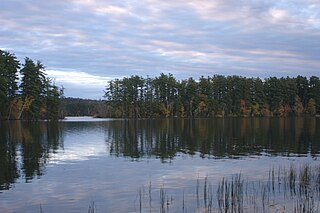
Horn Pond is a 227-acre (92 ha) water body located on the border of Acton, Maine, and Wakefield, New Hampshire, in the United States. The lake is both spring-fed and fed by the outflows of Great East Lake to the north and Wilson Lake to the east. Horn Pond's outlet is the Salmon Falls River which forms a natural border between Maine and New Hampshire and empties into the Piscataqua River east of Dover, New Hampshire, and ultimately the Gulf of Maine.

Bridgton is a town in Cumberland County, Maine, United States. The population was 5,418 at the 2020 census. A resort area in Maine's Lakes Region, Bridgton is home to Bridgton Academy, a private preparatory school, and the Four on the Fourth Road Race.

Beech Hill Pond is a lake in Otis, Hancock County, Maine, in the United States. It is 4.5 miles (7.2 km) long, half a mile wide, and up to 104 feet (32 m) deep. Trout, salmon, and other species of fish have been observed in the lake. Bald eagles and loons also live on the shoreline.
Winthrop is a town in Kennebec County, Maine, United States. Winthrop is included in the Lewiston-Auburn, Maine metropolitan New England city and town area. The population was 6,121 at the 2020 census. Winthrop's population, however, approximately doubles during the summer months as part-year residents return to seasonal camps located on the shores of Winthrop's Lakes and Ponds. A recreational area located among lakes, the town includes the villages of Winthrop and East Winthrop, and is the center of the Winthrop Lakes Region. Winthrop is included in the Augusta, Maine Micropolitan New England City and Town Area.

Crescent Lake is a lake in Raymond, Maine, United States. It is located around 3.5 miles (5.6 km) north of the center of Raymond. A few other lakes surround it, including Panther Pond to the south, Raymond Pond to the east, Thompson Lake to the north and Dumpling Pond and Coffee Pond to the west. It has a surface area of 716 acres (3 km2) and a maximum depth of 54 ft (16 m), which occurs in its northeastern section. Its shoreline runs for 8.9 miles (14.3 km).


