Chocorua, New Hampshire | |
|---|---|
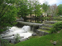 A dam on the Chocorua River in Chocorua | |
 Chocorua  Chocorua | |
| Coordinates: 43°52′39″N71°13′13″W / 43.87750°N 71.22028°W | |
| Country | United States |
| State | New Hampshire |
| County | Carroll |
| Town | Tamworth |
| Elevation | 525 ft (160 m) |
| Time zone | UTC-5 (Eastern (EST)) |
| • Summer (DST) | UTC-4 (EDT) |
| ZIP code | 03817 |
| Area code | 603 |
| GNIS feature ID | 871674 [1] |
Chocorua is an unincorporated community within the town of Tamworth in Carroll County, New Hampshire, United States. It is located in the general area where Routes 16 and 113 meet, south of Mount Chocorua and Chocorua Lake.
