| Wolfeboro Falls, New Hampshire | |
|---|---|
| Unincorporated community | |
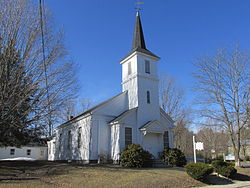
First Baptist Church | |
 Wolfeboro Falls  Wolfeboro Falls | |
| Coordinates: 43°35′26″N71°12′18″W / 43.59056°N 71.20500°W Coordinates: 43°35′26″N71°12′18″W / 43.59056°N 71.20500°W | |
| Country | United States |
| State | New Hampshire |
| County | Carroll |
| Town | Wolfeboro |
| Elevation | 518 ft (158 m) |
| Time zone | Eastern (EST) (UTC-5) |
| • Summer (DST) | EDT (UTC-4) |
| ZIP code | 03896 |
| Area code(s) | 603 |
| GNIS feature ID | 870972 [1] |
Wolfeboro Falls is an unincorporated community in the town of Wolfeboro in Carroll County, New Hampshire, United States. It is located 0.5 miles (0.8 km) north of the center of Wolfeboro, on the strip of land separating Front Bay (connecting to Lake Winnipesaukee) from Crescent Lake (connecting to Lake Wentworth). The stream connecting the two lakes, known as the "Smith River", drops 28 feet (8.5 m) over its 0.3-mile (0.5 km) course.

In law, an unincorporated area is a region of land that is not governed by a local municipal corporation; similarly an unincorporated community is a settlement that is not governed by its own local municipal corporation, but rather is administered as part of larger administrative divisions, such as a township, parish, borough, county, city, canton, state, province or country. Occasionally, municipalities dissolve or disincorporate, which may happen if they become fiscally insolvent, and services become the responsibility of a higher administration. Widespread unincorporated communities and areas are a distinguishing feature of the United States and Canada. In most other countries of the world, there are either no unincorporated areas at all, or these are very rare; typically remote, outlying, sparsely populated or uninhabited areas.

Wolfeboro is a town in Carroll County, New Hampshire, United States. The population was 6,269 at the 2010 census. A resort area situated beside Lake Winnipesaukee, Wolfeboro includes the village of Wolfeboro Falls.

Carroll County is a county in the U.S. state of New Hampshire. As of the 2010 census, the population was 47,818, making it the third-least populous county in New Hampshire. Its county seat is Ossipee. The county was created in 1840 and organized at Ossipee from towns removed from Strafford County. It was named in honor of Charles Carroll of Carrollton, who had died in 1832, the last surviving signer of the United States Declaration of Independence.
New Hampshire Route 28 passes through the village, leading to Ossipee to the north and Alton to the south. New Hampshire Route 109A leaves Route 28 at the center of the village, heading northwest towards Center Tuftonboro and Melvin Village.

New Hampshire Route 28 is an 85.413-mile-long (137.459 km) north–south state highway in eastern New Hampshire. It connects the town of Ossipee in east-central New Hampshire with Salem on the Massachusetts border, while passing through Manchester, the largest city in the state.

Ossipee is a town in Carroll County, New Hampshire, United States. The population was 4,345 at the 2010 census. It is the county seat of Carroll County. Ossipee, which includes several villages, is a resort area and home to part of Pine River State Forest.

Alton is a town in Belknap County, New Hampshire, United States. The population was 5,250 at the 2010 census. It is home to Alton Bay State Forest and Mount Major State Forest.
Wolfeboro Falls has a ZIP code of 03896, different from the rest of the town of Wolfeboro.