Jackson, New Hampshire

Last updated

Jackson, New Hampshire
Town
Covered Bridge Jackson NH.JPG
Jackson Town Seal.png
Motto: 
"Bridging the Centuries"
Carroll-Jackson-NH.png
Coordinates: 44°08′45″N71°10′51″W / 44.14583°N 71.18083°W / 44.14583; -71.18083
Country United States
State New Hampshire
County Carroll
Incorporated December 4, 1800
Government
   Board of Selectmen
  • Frank DeFruscio, Chair
  • Barbara Campbell
  • Bob Thompson
  Town AdministratorJulie Atwell
Area
[1]
  Total66.8 sq mi (173.0 km2)
  Land66.8 sq mi (172.9 km2)
  Water0.04 sq mi (0.1 km2)  0.06%
Elevation
758 ft (231 m)
Population
 (2020) [2]
  Total1,028
  Density15/sq mi (5.9/km2)
Time zone UTC-5 (Eastern)
  Summer (DST) UTC-4 (Eastern)
ZIP code
03846
Area code 603
FIPS code 33-38260
GNIS feature ID0873632
Website www.jackson-nh.org

Jackson is a town in Carroll County, New Hampshire, United States. The population was 1,028 at the 2020 census, [2] up from 816 at the 2010 census. [3] Jackson is a resort area in the White Mountains. Parts of the White Mountain National Forest are in the west, north and east.

Contents

History

Bird's-eye view in 1907 Jackson, NH from Iron Mountain.jpg
Bird's-eye view in 1907

Once consisting of several large land grants by colonial Governor John Wentworth, the town was first named "New Madbury", after the seacoast town of Madbury. In 1772, a road was built through Pinkham Notch, and the area was first settled in 1778 by Benjamin Copp and his family. In 1800, the community was renamed in honor of President John Adams, who was then in office. The name "Adams" stuck until the town was incorporated in 1829, when Andrew Jackson, the hero of the Battle of New Orleans, was inaugurated president. Governor Benjamin Pierce, a staunch backer of President Jackson, was influential in changing the name to Jackson. Only one vote was cast against the switch. In 2021, town residents voted to rededicate the town name to honor geologist Charles Thomas Jackson (1805–1880) rather than Andrew Jackson. [4]

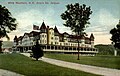
In 1847, artists of the White Mountain School began arriving in Jackson to paint the scenic beauty of the White Mountains. Others would follow, and in 1858, Joshua B. Trickey opened the Jackson Falls House. The Portland & Ogdensburg Railroad began service to Glen station at nearby Bartlett in the early 1870s, and several hotels were built to accommodate a growing infusion of tourists. Thorn Mountain House, built by Trickey in 1869, would evolve during the 1880s into Wentworth Hall, still in business today. Designed as a grouping of cottages around a main service building, the hotel included such amenities as a casino, built in 1886, and a hydroelectric plant, built in the 1890s. By the 1920s, 40 trains a day delivered passengers to Jackson.

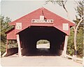
The increasing use of automobiles, however, reduced travel by train, as vacationers could venture beyond the limits of rail service. Consequently, some grand 19th century hotels lost patrons and closed, although the town itself would never lose popularity. Jackson is one of the region's most picturesque villages, famous in part for Jackson Falls and Jackson X-C, a 100 kilometer cross-country skiing trail system, rated one of the best in the world. [5] Wildcat Mountain, with an impressive view of Mount Washington, is a popular alpine skiing destination that was purchased by Vail Resorts in 2019. [6] Jackson is perhaps best known for its red covered bridge (the Honeymoon Bridge), built in 1876, one of the most photographed in the state.

Geography

According to the United States Census Bureau, the town has a total area of 66.8 square miles (173.0 km2), of which 0.04 square miles (0.1 km2), or 0.06%, are water. [1] Jackson is drained by the Ellis River and its tributary Wildcat Brook. The highest point in Jackson is 3,870 feet (1,180 m) above sea level on Wildcat Ridge, at the northern boundary of town. The ridge continues to rise north of the town border to the summit of Wildcat Mountain4,422 ft (1,348 m)—in the neighboring township of Bean's Purchase. Jackson lies fully within the Saco River watershed. [7]

Adjacent municipalities

Demographics

Historical population
CensusPop.Note
1850 589
1860 6317.1%
1870 474−24.9%
1880 464−2.1%
1890 57924.8%
1900 6247.8%
1910 452−27.6%
1920 53317.9%
1930 321−39.8%
1940 40927.4%
1950 344−15.9%
1960 315−8.4%
1970 40428.3%
1980 64258.9%
1990 6785.6%
2000 83523.2%
2010 816−2.3%
2020 1,02826.0%
U.S. Decennial Census [2] [8]
Old Town Hall in 2001 Jackson NH Town Hall 1897.JPG
Old Town Hall in 2001

As of the census [9] of 2000, there were 835 people, 377 households, and 240 families residing in the town. The population density was 12.5 people per square mile (4.8/km2). There were 910 housing units at an average density of 13.6 per square mile (5.2/km2). The racial makeup of the town was 99.28% White, 0.24% Native American, 0.12% Asian, 0.12% Pacific Islander, and 0.24% from two or more races. Hispanic or Latino of any race were 0.12% of the population.

There were 377 households, out of which 21.0% had children under the age of 18 living with them, 57.8% were married couples living together, 5.0% had a female householder with no husband present, and 36.1% were non-families. 27.1% of all households were made up of individuals, and 10.3% had someone living alone who was 65 years of age or older. The average household size was 2.18 and the average family size was 2.67.

Fairview Bridge in 1912 Fairview Bridge, Jackson, NH.jpg
Fairview Bridge in 1912

In the town, the population was spread out, with 18.0% under the age of 18, 2.2% from 18 to 24, 28.7% from 25 to 44, 29.3% from 45 to 64, and 21.8% who were 65 years of age or older. The median age was 46 years. For every 100 females, there were 99.3 males. For every 100 females age 18 and over, there were 99.1 males.

The median income for a household in the town was $49,583, and the median income for a family was $59,327. Males had a median income of $32,813 versus $26,667 for females. The per capita income for the town was $25,718. About 6.1% of families and 8.1% of the population were below the poverty line, including 4.7% of those under age 18 and 14.5% of those age 65 or over.

Related Research Articles

<span class="mw-page-title-main">Lincoln, New Hampshire</span> Town in New Hampshire, United States

Lincoln is a town in Grafton County, New Hampshire, United States. It is the second-largest town by area in New Hampshire. The population was 1,631 at the 2020 census. The town is home to the New Hampshire Highland Games and to a portion of Franconia Notch State Park. Set in the White Mountains, large portions of the town are within the White Mountain National Forest. The Appalachian Trail crosses the western and northeastern parts of the town. Lincoln is the location of Loon Mountain Ski Resort and associated recreation-centered development.

<span class="mw-page-title-main">Bartlett, New Hampshire</span> Town in New Hampshire, United States

Bartlett is a town in Carroll County, New Hampshire, United States. The population was 3,200 at the 2020 census, up from 2,788 at the 2010 census. Bartlett includes the unincorporated community of Glen as well as portions of the communities of Kearsarge and Intervale, which the town shares with the neighboring town of Conway. It is set in the White Mountains and is surrounded by the White Mountain National Forest. It is home to the Attitash Mountain Resort and the Story Land theme park.

<span class="mw-page-title-main">Chatham, New Hampshire</span> Town in New Hampshire, United States

Chatham is a town in Carroll County, New Hampshire, United States. The population was 341 at the 2020 census. It is located in the White Mountains, and except for the southeast corner, all of Chatham is in the White Mountain National Forest. The town is home to the Cold River national forest campgrounds.

<span class="mw-page-title-main">North Conway, New Hampshire</span> Census-designated place in New Hampshire, United States

North Conway is a census-designated place (CDP) and village in eastern Carroll County, New Hampshire, United States. The population was 2,116 at the 2020 census. A year-round resort area, North Conway is the second-largest village within the town of Conway, after the village of Conway proper. North Conway maintains its own fire station, post office and public library, sharing its other services with Conway. The White Mountain National Forest is to the west and north. The area is home to Cathedral Ledge, Echo Lake State Park, and Cranmore Mountain Resort. North Conway is known for its large number of outlet shops.

<span class="mw-page-title-main">Carroll, New Hampshire</span> Town in New Hampshire, United States

Carroll is a town in Coös County, New Hampshire, United States. The population was 820 at the 2020 census. The two largest villages are Twin Mountain and Bretton Woods. Carroll is an important access point for recreational areas in the White Mountains, including many 4,000-footers, the Zealand River area, the Presidential Range, and the Presidential Dry River Wilderness. The town is home to the Mount Washington Hotel at Bretton Woods and to the Highland Center at Crawford Notch, the Appalachian Mountain Club's four-season lodge.

<span class="mw-page-title-main">Northumberland, New Hampshire</span> Town in New Hampshire, United States

Northumberland is a town located in western Coös County, New Hampshire, U.S., north of Lancaster. It is part of the Berlin, NH–VT micropolitan statistical area. As of the 2020 census, the town population was 2,126, of whom 1,068 lived in the village of Groveton.

<span class="mw-page-title-main">Pinkham's Grant, New Hampshire</span> Township in Coos County, New Hampshire, United States

Pinkham's Grant is a township in Coös County, New Hampshire, United States. The grant lies entirely within the White Mountain National Forest. As of the 2020 United States census, the population of the grant was zero.

<span class="mw-page-title-main">Wentworth Location, New Hampshire</span> Township in Coos County, New Hampshire, United States

Wentworth Location is a township in Coös County, New Hampshire, United States. Its population was 28 at the 2020 census. It is part of the Berlin, NH–VT Micropolitan Statistical Area.

<span class="mw-page-title-main">Benton, New Hampshire</span> Town in New Hampshire, United States

Benton is a town in Grafton County, New Hampshire, United States. The population was 374 at the 2020 census. Located in the White Mountains, Benton is largely surrounded by the White Mountain National Forest. The town is crossed by the Appalachian Trail.

<span class="mw-page-title-main">Campton, New Hampshire</span> Town in New Hampshire, United States

Campton is a town in Grafton County, New Hampshire, United States. The population was 3,343 at the 2020 census. Campton, which includes the villages of Blair, Campton Hollow, Lower Campton and West Campton, is home to Blair State Forest and Livermore Falls State Forest. It is located in the foothills of the White Mountains, and parts of the White Mountain National Forest are in the northeast and northwest.

<span class="mw-page-title-main">Franconia, New Hampshire</span> Town in New Hampshire, United States

Franconia is a town in Grafton County, New Hampshire, United States. The population was 1,083 at the 2020 census. Set in the White Mountains, Franconia is home to the northern half of Franconia Notch State Park. Parts of the White Mountain National Forest are in the eastern and southern portions of the town. The Appalachian Trail crosses the town.

<span class="mw-page-title-main">Monroe, New Hampshire</span> Town in New Hampshire, United States

Monroe is a town in Grafton County, New Hampshire, United States. The population was 864 at the 2020 census, up from 788 at the 2010 census. The town is located along the Connecticut River, across from Barnet, Vermont. It was originally chartered as part of Lyman.

<span class="mw-page-title-main">Sugar Hill, New Hampshire</span> Town in New Hampshire, United States

Sugar Hill is a town in Grafton County, New Hampshire, United States. The population was 647 at the 2020 census, an increase over the figure of 563 tabulated in 2010. The town overlooks the White Mountain National Forest, with views of the Presidential, Franconia, Kinsman and Dalton ranges. Sugar Hill was incorporated as a town in 1962, the most recent in New Hampshire.

<span class="mw-page-title-main">Warren, New Hampshire</span> Town in New Hampshire, United States

Warren is a town in Grafton County, New Hampshire, United States. The population was 825 at the 2020 census, down from 904 at the 2010 census. Warren includes the village of Glencliff. The Appalachian Trail crosses the town in the west.

<span class="mw-page-title-main">Bennington, New Hampshire</span> Town in New Hampshire, United States

Bennington is a town in Hillsborough County, New Hampshire, United States. The population was 1,501 at the 2020 census.

<span class="mw-page-title-main">Temple, New Hampshire</span> Town in New Hampshire, United States

Temple is a town in Hillsborough County, New Hampshire, United States. The population was 1,382 at the 2020 census. It is home to Temple Mountain State Reservation, formerly the Temple Mountain Ski Area.

<span class="mw-page-title-main">Madbury, New Hampshire</span> Town in New Hampshire, United States

Madbury is a town in Strafford County, New Hampshire, United States. The population was 1,918 at the 2020 census.

<span class="mw-page-title-main">Wentworth, New Hampshire</span> Town in New Hampshire, United States

Wentworth is a town in Grafton County, New Hampshire, United States. The population was 845 at the 2020 census, down from 911 at the 2010 census. The town is home to Plummer's Ledge Natural Area, and part of the White Mountain National Forest is in the northeast. The town has a picturesque common, presided over by a Federal-style church and bordered by antique homes.

The Berlin Micropolitan Statistical Area is the core-based statistical area centered on the urban cluster associated with the city Berlin, New Hampshire, in the United States. As defined by the Office of Management and Budget using counties as building blocks, the area consists of two counties – Coos County in New Hampshire, which contains the city of Berlin, and the adjacent Essex County in Vermont.

<span class="mw-page-title-main">Gorham, New Hampshire</span> Town in New Hampshire, United States

Gorham is a town in Coös County, New Hampshire, United States. The population was 2,698 at the 2020 census. Gorham is located in the White Mountains, and parts of the White Mountain National Forest are in the south and northwest. Moose Brook State Park is in the west. Tourism is a principal business. It is part of the Berlin, NH–VT Micropolitan Statistical Area.

References

  1. 1 2 "2021 U.S. Gazetteer Files – New Hampshire". United States Census Bureau. Retrieved November 1, 2021.
  2. 1 2 3 "Jackson town, Carroll County, New Hampshire: 2020 DEC Redistricting Data (PL 94-171)". U.S. Census Bureau. Retrieved November 1, 2021.
  3. United States Census Bureau, American FactFinder, 2010 Census figures. Retrieved March 23, 2011.
  4. McKenzie, Margaret (May 17, 2021). "Jackson voters rededicate town, ban fireworks". The Conway Daily Sun. Retrieved November 1, 2021.
  5. "About – Jackson XC" . Retrieved August 25, 2022.
  6. Brooks, David (September 24, 2019). "Vail completes purchase of Crotched, Wildcat and Attitash ski areas in N.H." Concord Monitor. Retrieved August 8, 2022.
  7. Foster, Debra H.; Batorfalvy, Tatianna N.; Medalie, Laura (1995). Water Use in New Hampshire: An Activities Guide for Teachers. U.S. Department of the Interior and U.S. Geological Survey.
  8. "Census of Population and Housing". Census.gov. Retrieved June 4, 2016.
  9. "U.S. Census website". United States Census Bureau . Retrieved January 31, 2008.