
Jackson is a town in Carroll County, New Hampshire, United States. The population was 1,028 at the 2020 census, up from 816 at the 2010 census. Jackson is a resort area in the White Mountains. Parts of the White Mountain National Forest are in the west, north and east.

The Cornish–Windsor Covered Bridge is a 158-year-old, two-span, timber Town lattice-truss, interstate, covered bridge that crosses the Connecticut River between Cornish, New Hampshire, and Windsor, Vermont. Until 2008, when the Smolen–Gulf Bridge opened in Ohio, it had been the longest covered bridge in the United States.

The Mount Orne Bridge is a covered bridge over the Connecticut River between Lancaster, New Hampshire, and Lunenburg, Vermont. It joins Elm Street in South Lancaster with River Road in Lunenburg. Built in 1911, it is one of two Howe truss bridges across the Connecticut River. It was listed on the National Register of Historic Places in 1976.

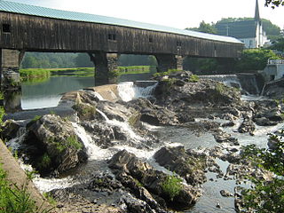
The Bellows Falls Arch Bridge was a three-hinged steel through arch bridge over the Connecticut River between Bellows Falls, Vermont and North Walpole, New Hampshire. It was structurally significant as the longest arch bridge in the United States when it was completed in 1905.
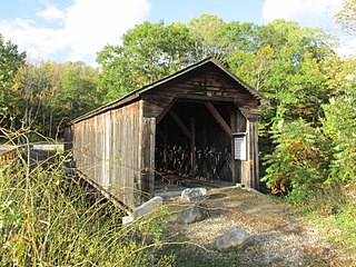
The Cold River Bridge, also known as McDermott Bridge, is a historic wooden covered bridge spanning the Cold River near Crane Brook Road in Langdon, New Hampshire, USA. Built in 1869, it is one of the state's few surviving 19th-century covered bridges. It was listed on the National Register of Historic Places in 1973. It is closed to vehicular traffic.

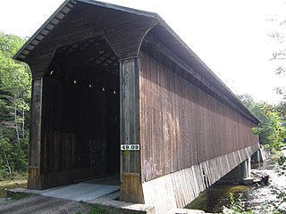
The Whittier Bridge is a historic wooden covered bridge in Ossipee, New Hampshire. The bridge carried an old alignment of New Hampshire Route 25 over the Bearcamp River. Built in 1870, it is one of New Hampshire's few surviving 19th-century covered bridges, and a rare example of a Paddleford truss. The bridge was listed on the National Register of Historic Places in 1984. It was closed to vehicular traffic in 1989, and was removed from its footings for restoration in 2008. As of September 2019, the bridge is resting on Nudd Road adjacent to the crossing point. It was placed back on its abutments in the late fall of 2022.
The Bath Covered Bridge is a historic covered bridge over the Ammonoosuc River off US 302 and NH 10 in Bath, New Hampshire. Built in 1832, it is one of the state's oldest surviving covered bridges. It was listed on the National Register of Historic Places in 1976, and underwent a major rehabilitation in the 2010s.
The Haverhill–Bath Covered Bridge is a historic covered bridge over the Ammonoosuc River joining Bath and Woodsville, New Hampshire. Formerly used to carry New Hampshire Route 135, the bridge was idled in 1999. Restored in 2004, it is now open to foot traffic only. It is believed to be the oldest covered bridge in the state.

The Contoocook Railroad Bridge is a covered bridge on the former Contoocook Valley Railroad line spanning the Contoocook River in the center of the village of Contoocook, New Hampshire, United States. It is referred to in the National Register of Historic Places as the Hopkinton Railroad Covered Bridge, for the town of Hopkinton, New Hampshire, in which the village of Contoocook is located.
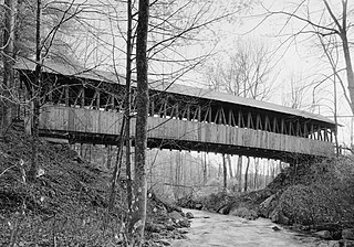
The Hancock–Greenfield Bridge is a historic covered bridge carrying Forest Road over the Contoocook River at the town line between Hancock and Greenfield, New Hampshire. The New Hampshire Department of Transportation covered bridge database refers to it as County Bridge. Built in 1937, it is the first wooden covered bridge in the northeastern United States to use modern engineering techniques. The bridge was listed on the National Register of Historic Places in 1981.

The White Mountain Central Railroad is a short heritage railway at Clark's Bears in Lincoln, New Hampshire. It is notable as being one of the few places in New England with regular steam locomotive operation, as well as being a very rare example of a purpose-built tourist railroad that uses standard-gauge track instead of narrow-gauge track.
Clark's Bears, named Clark's Trading Post until 2019, is a visitor attraction in Lincoln, New Hampshire, United States, in the White Mountains. It is known for its trained bears and for the White Mountain Central Railroad, a 30-minute, 2.5-mile (4.0 km) steam-powered train ride. The attraction is located along U.S. Route 3, one mile (1.6 km) north of the village of North Woodstock and 9 miles (14 km) south of Franconia Notch.

The Sulphite Railroad Bridge, also known locally as the Upside-Down Covered Bridge is a historic railroad bridge in Franklin, New Hampshire. The bridge was built circa 1896-7 to carry the tracks of the Boston and Maine Railroad across the Winnipesaukee River between Franklin and Tilton. The bridge is believed to be the only surviving "upside down" covered railroad bridge in the United States, in which the rail bed is laid on top of the bridge roof, whose purpose is to shelter the trusses below. The bridge was listed on the National Register of Historic Places in 1975. The bridge, unused since 1973, is not in good condition, having been subjected to graffiti, vandalism, and arson, as well as the elements.

The Hillsborough Railroad Bridge was a historic covered railroad bridge spanning the Contoocook River in Hillsborough, New Hampshire. Built in 1903 by the Boston and Maine Railroad, it was destroyed by arson in 1985. The bridge was listed on the National Register of Historic Places in 1975. At the time of its nomination it was one of six covered railroad bridges in the state; it and at least one other were destroyed by the actions of arsonists.
Wright's Bridge is a historic covered bridge in Newport, New Hampshire. Originally built in 1906 to carry the Boston and Maine Railroad across the Sugar River, it now carries the multi-use Sugar River Trail. The bridge was listed on the National Register of Historic Places in 1975.
The Kenyon Bridge, also known as the Blacksmith Shop Bridge, is a historic covered bridge spanning Mill Brook near Town House Road in Cornish, New Hampshire, United States. Built in 1882, it is one of New Hampshire's few surviving 19th-century covered bridges. It was listed on the National Register of Historic Places in 1978.
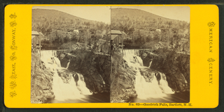
Goodrich Falls is a populated place in the town of Bartlett along the Ellis River in Carroll County, New Hampshire, United States. The falls were featured in stereoscopic images in the 19th century including by Kilburn Brothers and Nathan W. Pease. New Hampshire Route 16 bridges the river just upstream from the falls.

Best's Covered Bridge(akaSwallow's Bridge) is a historic covered bridge in West Windsor, Vermont, that carries Churchill Road over Mill Brook, just south of Vermont Route 44. Built in 1889, it is an architecturally distinctive laminated arch structure with a post-and-beam superstructure. It was listed on the National Register of Historic Places in 1973.

Wildcat Brook, also known as the Wildcat River, is a 9.05-mile-long (14.56 km) stream in the White Mountains of New Hampshire, in the United States. It rises at Carter Notch in the township of Bean's Purchase in Coos County, and flows south through the town of Jackson in Carroll County to its confluence with the Ellis River near the town's southern boundary. At Jackson Falls, near the town center, the stream descends 120 feet (37 m) in 1⁄4 mile (0.4 km) over granite ledges, paralleled by New Hampshire Route 16B. The surrounding area is part of the Jackson Falls Historic District.

