Jackson Covered Bridge

Last updated
Jackson Covered Bridge
Jackson Bridge 2009.jpg
Jackson Covered Bridge c. 2009
Coordinates 39°52′48.09″N87°16′56.63″W / 39.8800250°N 87.2823972°W / 39.8800250; -87.2823972 Coordinates: 39°52′48.09″N87°16′56.63″W / 39.8800250°N 87.2823972°W / 39.8800250; -87.2823972
CarriesBloomingdale Road (C.R.25)
CrossesSugar Creek, Parke County, Indiana
Locale Rockport, Parke, Indiana, United States
Official nameJackson Covered Bridge
Other name(s)Rockport Bridge or Wright's Mill Bridge
Named for Andrew Jackson
Maintained by Parke County
WGCB # 14-61-28 [1]
Characteristics
DesignDouble Burr arch truss bridge, double king post [2]
MaterialHewn stone (foundations)
Trough constructionWood
Total length225 ft (68.6 m) (includes 9 ft (2.7 m) overhangs on each end)
Width16 ft (4.9 m)
Longest span207 ft (63.1 m)
No. of spans1
Clearance above 18 ft (5.5 m)
History
Construction cost$8,000 plus subscriptions
Jackson Covered Bridge (#19)
Locator map of Parke County, Indiana.svg
Red pog.svg
Location of Jackson Covered Bridge
USA Indiana location map.svg
Red pog.svg
Location of Jackson Covered Bridge
Usa edcp location map.svg
Red pog.svg
Location of Jackson Covered Bridge
Built1861 (1861)
Built by J. J. Daniels
Website Jackson Bridge
Part ofParke County Covered Bridges TR (ID64000193)
NRHP reference No. 78000393 [3]
Added to NRHPDecember 22, 1978
Location
Jackson Covered Bridge

The Jackson Covered Bridge also known as the Rockport Covered Bridge is located in the 'forgotten town' of Rockport, northwest of Bloomingdale, Parke County, Indiana, USA.

Contents

History

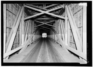
It was built by J. J. Daniels in 1861, and is the oldest remaining bridge built by him. Crossing Sugar Creek, on county road 83 at the intersection with county roads 25 and 232, it is a single span Double Burr Arch truss covered bridge structure built on a base of hewn stone. [4] [5]

Prior Wright had built his second mill in the area of 'Devil's Den' in 1848, after his mill located at The Narrows was washed away by a freshet on New Year's Day 1847. During this time, flat boats would be built and floated over the shallows of Sugar Creek during high waters for the trip to the markets in New Orleans. When the Wabash and Erie Canal came through more business originated from here.

Eventually the mill, a general store, cooper shop, blacksmith shop, two sawmills, and four dwelling houses would come to make up the town of Rockport. In addition, an iron smelter operated for a while using a poor grade of iron ore and the plentiful and high grade coke made from local coal.

By December 1860, the citizens of the area had decided to call on Dr. Hobbs to be their spokesman for a new bridge near Wright's Mill. Dr. Hobbs called upon the Parke County Commissioners to hold a special meeting, and on December 28, they discuss the issue of "several citizens who had presented a petition for a bridge over Sugar Creek at Wright's Upper Mills." John Scott, "presented on behalf of various citizens a petition and subscriptions for a bridge at Star Mills," at the same meeting.

Just four days later on New Year's Day 1861, the commissioners held another special meeting and approved both bridges to be built with $8,000 from the county, "...provided the citizens would make up enough subscriptions to make up the balance on the cost of these two bridges."

Within a week and a half, January 17, $3,307 and 300 signatures had been collected by the petition leaders Byers, Milligan, Graham, and Elwood Hadley. James Johnson and Henry Wolf were appointed to select sites for the bridges, establish specifications and provide estimates for the county commissioners.

Back in 1859, the Parke County Commissioners had received a letter from J. J. Daniels, on the behalf of William D. Daniels, on the proposal of building bridges at Wright's Mill and Star Mills. Bids were opened at the March 1861 meeting. William D. Daniels was awarded the bid and on April 22, the contracts were signed, filed, and $1,000 advance was allowed. Brown and Company had finished the masonry work, that had been subcontracted out to them, for the abutments by September 16, and Mr. Daniels was given $6,000 to pay for the work. This was to be the only bridge in Parke County built by J. J. Daniels that would contain a cornerstone in the abutment. The cornerstone is located in the south upstream side of the bridge and reads, "Builder J. J. Daniels 1861". On November 9, 1861, the bridge was ready for its final inspection by the county commissioners and on November 11, Daniels was paid $1,500 for the Jackson bridge contract and an additional $2,500. The additional amount may have been for the Star Mills Bridge which was completed in December.

It is the longest single span covered bridge in Indiana and the oldest bridge still standing built by J. J. Daniels.

Built during the unstable political era of the American Civil War, J. J. Daniels wanted to make a clear political statement and named the bridge after Andrew Jackson to honor his statement to John Calhoun: "To the Union, it must be preserved." When the bridge was first built the portal was lettered: "The Federal Union: It must be preserved." [4]

It was added to the National Register of Historic Places in 1978. [3]

See also

Related Research Articles

<span class="mw-page-title-main">Mansfield Covered Bridge</span> Bridge in Indiana, United States

The Mansfield Covered Bridge is a Double Burr Arch double span truss bridge located on Mansfield Road (historic) and Big Raccoon Creek in Mansfield southeast of Rockville in Parke County, Indiana. Built by Joseph J. Daniels in 1867 at a cost of $12,200. At 279 ft (85 m) it is the second longest covered bridge left in Parke County. This Historic Site rest on land provided by Luke Moody, of Parke County, Indiana and is open to the public all year.

<span class="mw-page-title-main">Conley's Ford Covered Bridge</span> Bridge in Parke County, Indiana

Conley's Ford Covered Bridge was built in 1906 and crosses Big Raccoon Creek on County Road 550 East close to County Road 720 South, in Parke County, IN. The bridge is a single span Burr Arch Truss structure. The Conley's Ford Covered Bridge was built by J. Lawrence Van Fossen.

<span class="mw-page-title-main">Bridgeton Covered Bridge</span> Bridge in Bridgeton, Indiana

The first Bridgeton covered bridge was a double-span Burr Arch bridge built in 1868 by a crew led by J. J. Daniels. It was closed to traffic in 1967. It was built to replace two prior open wooden bridges that had fallen in. After its destruction by fire, it was replaced in 2006 by a reproduction.

<span class="mw-page-title-main">Nevins Covered Bridge</span> Place in Indiana listed on National Register of Historic Places

The Nevins Covered Bridge is a single span Burr Arch Truss covered bridge that crosses Little Raccoon Creek on County Road 130 East, just southeast of Catlin, Indiana. It was built in 1920 by Joseph A. Britton and Son. Prior to the reconstruction of the Bridgeton Bridge in 2006, the Nevins Bridge was the newest covered bridge in Parke County.

<span class="mw-page-title-main">Crooks Covered Bridge</span> Bridge in Parke County, Indiana

The Crooks Covered Bridge is a single span Burr Arch Truss structure that crosses Little Raccoon Creek built in 1855-1856 by Henry Wolf just southeast of Rockville, Indiana.

<span class="mw-page-title-main">Beeson Covered Bridge</span> Bridge in Parke County, Indiana

The Beeson Covered Bridge originally crossed Roaring Creek, one mile (1.6 km) northwest of Marshall, Indiana, on County Road 216, in Washington Township, Parke County. The bridge was moved to its current location in Billie Creek Village in December 1979.

<span class="mw-page-title-main">Billie Creek Covered Bridge</span> Bridge in Parke County, Indiana

The Billie Creek Covered Bridge is a Burr Arch structure that was built by Joseph J. Daniels in 1895. J.L. Van Fossen supplied the sandstone that makes up the abutments cut from A.E. Fuel's nearby quarry.

<span class="mw-page-title-main">Parke County Covered Bridges</span>

The covered bridges of Parke County are well-known tourist attractions in Parke County, Indiana, United States, which touts itself as the "Covered Bridge Capital of the World". The county claims to have more covered bridges than any other county in the United States. This is due to several reasons, mainly due to the numerous streams and creeks in the county, and having the natural resources and designers to build the bridges.

<span class="mw-page-title-main">Leatherwood Station Covered Bridge</span> Place in Indiana listed on National Register of Historic Places

The Leatherwood Station Covered Bridge is a single span double Burr Arch Truss covered bridge structure that was built by Joseph A. Britton & Son in 1899. Originally it had sandstone abutments but when it was moved to Billie Creek Village they were replaced with concrete abutments with sandstone showing.

<span class="mw-page-title-main">Melcher Covered Bridge</span> Place in Indiana listed on National Register of Historic Places

The Melcher Covered Bridge, also known as the "Klondyke Covered Bridge", "Marion Covered Bridge", or the "Leatherwood Covered Bridge" crosses Leatherwood Creek east of Montezuma, Indiana, and is a single-span Burr Arch Truss covered bridge structure that was built by Joseph J. Daniels in 1896.

<span class="mw-page-title-main">Mill Creek Covered Bridge</span> Place in Indiana listed on National Register of Historic Places

The Mill Creek Covered Bridge also known as "Thompson's Ford Covered Bridge," "Tow Path Covered Bridge," or "Earl Ray Covered Bridge" crosses Wabash Mill Creek (historic) southwest of Tangier, Indiana. It is a single span Burr Arch Truss covered bridge structure that was built by D. M. Brown in 1907.

<span class="mw-page-title-main">Narrows Covered Bridge</span> Place in Indiana listed on National Register of Historic Places

The Narrows Covered Bridge crosses Sugar Creek at the eastern edge of Turkey Run State Park and is a single span Burr Arch Truss covered bridge structure that was built by Joseph A. Britton in 1882.

<span class="mw-page-title-main">Roseville-Coxville Covered Bridge</span> Bridge southeast of Mecca, Indiana

The Roseville Covered Bridge, also known as the Coxville covered bridge, is southeast of Mecca, Indiana. The double span Burr Arch covered bridge structure was built by Joseph J. Daniels in 1910. This is the third bridge at this location.

<span class="mw-page-title-main">West Union Covered Bridge (Indiana)</span> Place in Indiana listed on National Register of Historic Places

The West Union Covered Bridge formerly carried Tow Path Road over Sugar Creek north-northeast of Montezuma, Indiana. The two-span Burr Arch Truss covered bridge structure was built by Joseph J. Daniels in 1876. It is notable for being the longest standing covered bridge in Parke County, and one of the nation's best-preserved examples of the Burr truss.

<span class="mw-page-title-main">Wilkins Mill Covered Bridge</span> Place in Indiana listed on National Register of Historic Places

The Wilkins Mill Covered Bridge is north of Rockville, Indiana. The single span Burr Arch Truss covered bridge structure was built by William Hendricks in 1906. The bridge is 120 feet (37 m) long, 16 feet (4.9 m) wide, and 13 feet (4.0 m) high.

The Grange Corner Covered Bridge was west of Grange Corner, Indiana. The single-span Burr Arch covered bridge structure was built by the J. J. Daniels in 1899 and destroyed by flood in 1968.

The Harrison Covered Bridge was north of West Union, Indiana. The double-span Burr Arch covered bridge structure was built by J. J. Daniels in 1866 and damaged by flood waters in December 1875.

The Star Mill Covered Bridge was north of West Union, Indiana. The double-span Burr Arch covered bridge structure was built by J. J. Daniels in 1861 and destroyed by flood waters in 1866.

The Turkey Run Covered Bridge was north of Marshall, Indiana. The single-span Modified Queen Truss covered bridge structure was built by Joseph J. Daniels in 1865, 1866 or 1884, according to several conflicting sources, and dismantled in 1914 by order of the Parke County Commissioners, the abutments remain. It was one of two Queen Truss type covered bridges, the other being the JH Russell Covered Bridge

The Lusk Covered Bridge was once located north of Marshall, Indiana, United States. Two single-span dual lane Lattice Truss covered bridges were located at the site, one of which replaced the other. Salmon Lusk constructed the first bridge in 1840, and after its destruction by flood in 1847, Lusk constructed the second. Both bridges were located on private land; the only other such covered bridges in Parke County were the State Sanitorium Covered Bridge, the JH Russell Covered Bridge, and the Clinton Toll Bridge.

References

  1. "The Jackson Bridge". Indiana Covered Bridge Society. Retrieved 1 July 2021.
  2. "Jackson Covered Bridge (#28)". Parke County Convention & Visitors Commission. Retrieved 25 November 2019.
  3. 1 2 "National Register Information System  Jackson Bridge (#28) (#78000393)". National Register of Historic Places . National Park Service. January 23, 2007. Retrieved November 25, 2019.
  4. 1 2 "Jackson Covered Bridge (#28)". Parke County Convention & Visitors Commission. Retrieved 20 September 2016.
  5. "Indiana State Historic Architectural and Archaeological Research Database (SHAARD)" (Searchable database). Department of Natural Resources, Division of Historic Preservation and Archaeology. Retrieved 2016-06-01.Note: This includes Charles Felkner (December 1977). "National Register of Historic Places Inventory Nomination Form: Parke County Covered Bridge Historic District" (PDF). Retrieved 2016-06-01., Site map, and Accompanying photographs.